
Strengthening space-based terrestrial vegetation monitoring capability with the European Space Agency
Research by geographers at the University of Southampton has enhanced the European Space Agency (ESA) and European Commission’s (EC) capability to monitor global vegetation from space.
Issue
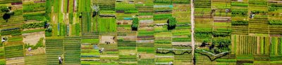
Reliable estimation of vegetation chlorophyll content is vital to forest and agricultural service providers who monitor crop yields, plant health, seasonality, carbon fluxes, and carbon sequestration. Accurate and near real-time estimation of vegetation chlorophyll content enables timely responses to poor harvests or plant disease outbreaks. It also enables improvements in carbon flux modelling and evaluation of vegetation response to climate change.
The ESA’s Medium Resolution Imaging Spectrometer (MERIS) satellite sensor ended suddenly in 2012 following unexpected loss of satellite contact, ending generations of the MERIS Terrestrial Chlorophyll Index product.
Approach
The research team developed and validated a second vegetation chlorophyll content product, the OLCI Terrestrial Chlorophyll Index, from the ESA’s Ocean and Land Imaging on the Sentinel-3A satellite.
Southampton’s algorithm underpinned the ESA’s development of the only global satellite data product that estimates terrestrial chlorophyll content in vegetation in near real-time.
The team also established a new procedure for validating satellite-derived vegetation chlorophyll content products at various sites.
Impact
The distribution of this data through the ESA and the Copernicus programme has generated major benefits for agricultural and environmental service providers. Copernicus programme users have deployed the OTCI to monitor and manage terrestrial ecosystems, including estimating forest and crop health.
The validation data are now routinely used by the EC to ensure that operational products meet user requirements. Since 2017 the EC has developed three satellite-based vegetation products which are used by more than 6,000 organisations for a range of applications, from monitoring biodiversity to drought surveillance.
More information
Institution: University of Southampton
Researchers: Professor Jadu Dash, Professor Sir Paul Curran, Dr Booker Oguto, Dr Francesco Vuolo
Share this resource
This is an open access article under the terms of the Creative Commons Attribution License (CC BY NC 4.0), which permits use, adaptation, distribution and reproduction in any medium or format, provided the original work is cited and it is for non-commercial purposes. Please contact us for other uses.
How to cite
Royal Geographical Society (with IBG) (2023) Strengthening space-based terrestrial vegetation monitoring capability with the European Space Agency. Available at https://rgs.org/terrestrialvegetation Last accessed on: <date>