
About the session
This online event will focus on introducing Digimap for Schools and how it can be used across the KS2 and KS3 curriculum. Darren Bailey from the Ordnance Survey will work through its functionality, map layers and more during an online demonstration, and will also provide ideas on how to use Digimap for Schools with KS2 and KS3 students. The session is ideal for new users to get an idea of what the product can do, or current users who are looking to further embed the use of maps into their curriculum.
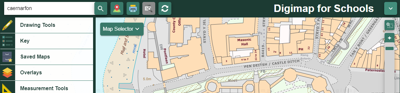
Digimap for Schools is an award winning online mapping service for use by teachers and pupils. With an intuitive interface, easy to understand tools and instructions, and no download or new software installation required, a teacher or a pupil can easily understand and start to use the service as soon as they log on. Digimap for Schools supports cross-curricula teaching of geography, maths, literacy, and history and also enables teachers and pupils to gain critical digital and data skills.
You can sign up to Digimap for Schools here.
Joining instructions
This free event is being run through Microsoft Teams. Details will be sent out to delegates a week in advance. If you do not receive this information please contact us preferably before the day of the event.
- Workshop

Choosing the right university and geography course
This session aims to support students in making the right choices for them when choosing both a university and a geography course.
Open to allWednesday 8 May 2024 - Workshop
Going further with GIS - Manchester Metropolitan University
This event is for teachers who have completed the Teach with GIS one-day CPD course and wish to further develop their knowledge and skills. Anyone who has previously attended Teach with GIS may sign up.
Manchester Metropolitan UniversityOpen to allWednesday 22 May 2024 - Workshop

Workshop for teachers: a discussion about our resources for schools
Secondary-level teachers with curriculum responsibility in geography are invited to discuss how you would like to see our free and member-only resources offer develop in future.
Royal Geographical Society (with IBG)Open to allTuesday 4 June 2024