Session summary
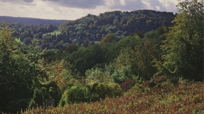
- The UK is committed to protect 30% of land for nature by 2030, agreed at the UN Biodiversity Summit during COP15 in 2022. This webinar explored England's approach to identifying land which could contribute to this target.
- Three criteria were identified for assessing where land would meet the aspirations of 30x30, these being purpose, protection, and management.
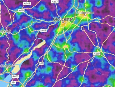
- Defra analysed a range of data sets, such as the England Peat Map, Wildlife Trusts and National Nature Reserves converting this into a 100km size grid, made up of 10m x 10m squares .This allows for an analysis of whether key features were present, or absent, in each gridded square, which can be used to assess whether the land meets the three criteria.
- Using this approach, it was calculated that around 10.5% of England currently meets or is on track to meet these criteria. This indicates a significant gap and the need for habitat creation and restoration to achieve the target.
- The role of protected landscapes is crucial in meeting the 30by30 goal, as they already contain a large proportion of land contributing or likely to contribute to 30by30.
- The assessment approach is already informing policy tools such as the Land Use Framework for England and supporting wider cross government planning for nature recovery.
About the speakers
Charlotte Weaver is a Spatial Data Scientist in DEFRA’s Spatial Data Science team. In her time at DEFRA, she has worked in areas such as 30by30, spatial targeting, climate adaptation, peatland mapping, and habitat regulation assessments. She has a strong interest in climate science and land use impacts, and has worked in these fields in both academia and the private sector.
Piumi Algamagedona is a Data Analyst within the Spatial Data Science team in DEFRA. She mainly works across projects such as 30by30, Government estate mapping, Environmental Indicator Framework and Farming in Protected Landscapes to develop pipelines and packages to aid analysis and generate dashboards.
Please note: The views of our speakers do not necessarily reflect the opinion of the Royal Geographical Society.
Note on captions
The Society aims to provide automatically-generated captions for all event recordings. The captions appear as text at the bottom of the video which you can toggle on and off.
The accuracy of automatically-generated captions varies depending on the audio quality, any specialist language used and the speaker. They are therefore are unlikely to be 100% accurate and the Society does not edit or correct automatically-generated captions.
- Webinar
Chartered Geographer introductory webinar - May
Join this webinar in May to learn more about the benefits of becoming a Chartered Geographer.
OnlineProfessionalsWednesday 13 May 2026 - Webinar
The connectivity tool: a data-led approach designed to achieve better spatial outcomes
Join an insightful webinar with the Department for Transport (DfT), exploring how the DfT Connectivity Tool unlocks sustainable development opportunities and analyses the spatial connectivity of an area.
OnlineProfessionalsWednesday 20 May 2026 - Webinar

Building networks and making the most of professional connections
Join this webinar for an interactive lunchtime discussion on building networks and making the most of professional connections.
OnlineProfessionalsThursday 21 May 2026