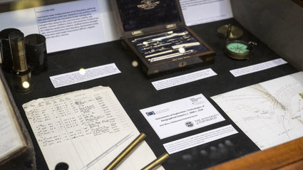
Instruments of exploration
Technologies of geographical enquiry, c. 1860-1939.
Research by Jane Wess.
September 2013 start, 2017 completion. University of Edinburgh: PI Professor Charles Withers.
Overview
The project studies the instruments of geographical exploration and their associated print and manuscript histories.
The Society holds a uniquely important set of instruments of geographical exploration. The project aims in general:
- To examine the Society's instrument collection in relation to contemporary debates about method, technology, credibility, and trust in geography, exploration, and the field-based empirical sciences;
- To extend existing collaborative work within the Society over the nature and importance of its historical holdings;
- To address questions about the authority of science, the role of instruments and instrumentation in developing truth claims, and establishing authority through standards and practices of authoritative measurement.
Find out more
A printed copy of this thesis is available for consultation in the Foyle Reading Room (reference only).
Please note that the British Library is currently working to restore its database following a cyber-security incident. An electronic copy of Jane's project will be available via EThOS (Electronic Theses Online Service) once the system is back online.
Selected publications from Jane's project
- Wess, J. and Withers, C. W. J. (2018) 'Instrument provision and geographical science: the work of the Royal Geographical Society, 1830–ca 1930', Notes and Records: the Royal Society Journal of the History of Science, 73 (2): 223–241. DOI: https://doi.org/10.1098/rsnr.2018.0034
- Wess, J. (2020) 'Colin Maclaurin (1698-1746) and his contemporaries on wind and water: the local and the universal', British Journal for the History of Mathematics, 35 (1): pp. 63-83. DOI: https://doi.org/10.1080/26375451.2019.1701861
- Wess, J. (2021) 'New light on the role of instruments in exploration during the 1830s' Notes Rec. https://doi.org/10.1098/rsnr.2021.0038
Primary resources for instruments in the Society's Collections
There are two manuscript books which are particularly pertinent. The first is ‘Instruments Lent to Travellers’ which was begun in 1860 and ends shortly after 1930 when Edward Reeves, the then Map Curator, retired. This volume actually lists the expeditions to which instruments were lent, not the instruments themselves.
The second volume began in 1879 and lists the instruments acquired and the date; if the instruments were purchased it records from whom and the cost. In a separate section it lists where each instrument went, with whom and the dates of the expedition. In this way the itineraries of all the 1,232 instruments procured from 1879 can be followed.
The procurement of instruments before 1879 can only be gleaned from the Council and Committee minutes and from the Journals. In 1851 the first listing appeared in the Journal, but this was not maintained on an annual basis.
Apart from supplying instruments the Society trained travellers to use them. This was done in two principal ways: publications and hands-on training. The society’s own advisory texts were produced from 1854 and were entitled Hints to Travellers.
All the eleven editions in the period from 1830 until 1930 contained advice on which instruments to use, and from the fifth edition, published in 1883, there was a considerable mathematical and technical element.
In addition to these texts the Society began a scheme for in-house training, delivered by the map curators Charles George, John Coles and Edward Reeves. Many of the potential borrowers received a high level of training in the most difficult observations and calculations, particularly longitude. The editions of Hints are indicative of what was taught, and some personal files also contain worked sheets of examples.
The personal files are the best source of information for conditions in the field. Many of the expeditions which borrowed instruments produced data which in turn produced journal manuscripts and published papers. Other results of the instruments included the bestowing of medals for the borrowers, so a range of the collection is involved.
Hints for using the Society's Collections
- Read all the various categories of material (council and committee minutes, personal archives, journal manuscripts etc) together for a particular event or time period. In this way you should get a more rounded picture.
- If you are studying an expedition, look at the images and sketch maps and compare them with the written accounts and the published maps respectively. Again this gives a feel for the discrepancies.
- The Finance committee minutes are revealing of what the Society considered worth spending on. This is not always entirely compatible with the stated aims.
- If you are interested in the instruments it is worth noting the craftsmanship and accuracy with which they can measure- Vernier scales etc, and consider this in combination with the circumstances in which they were used.
- If you are having difficulties reading the manuscripts don’t hurry. Return to the same piece several times and more will fit into place.
Further Reading
- 'The SAGE Handbook of Geographical Knowledge'. Eds: Agnew, John A. and Livingstone, David N. (Sage Publications; London; 2011).
- Alexander, Amir R. ‘Geometrical landscapes: the voyages of discovery and the transformation of mathematical practice.’ (Stanford University Press; Stanford; 2002).
- Bennett, Brett M. ‘Science and empire: knowledge and networks of science across the British Empire, 1800-1970.’ (Palgrave MacMillan; Basingstoke; 2011).
- 'Instruments, Travel and Science: Itineraries of Precision from the Seventeenth to the Twentieth Century'. (Eds) Bourguet, Marie-Noëlle, Licoppe, Christian and Sibum Heinz Otto (London; Routledge, 2002).
- Bridges Roy ‘Exploration and Travel Outside Europe 1720-1914’ in The Cambridge Companion to Travel Writing (Ed) Youngs, Tim (Cambridge; CUP; 2002).
- Driver, Felix ‘Geography Militant: Cultures of Exploration and Empire (Blackwell; Oxford; 2001).
- Golinski, Jan ‘Making Natural Knowledge: Constructivism and the History of Science’ (Cambridge: Cambridge University Press, 1998).
- Jones, Max ‘Measuring the world: exploration, empire and the reform of the Royal Geographical Society c. 1874-93’ in The Organisation of Knowledge in Victorian Britain, British Academy Centenary Monographs. (Ed) Daunton, M. J. (Oxford University Press, 2005).
- Dane Kennedy ‘The Last Blank Spaces: Exploring Africa and Australia’ (Harvard University Press; New Jersey; 2014).
- Livingstone, David N. ‘Landscapes of Knowledge’ in Geographies of Science (eds) Meusburger, Peter, Livingstone, David, and Jons Heike (New York and Heidelberg: Springer; 2010).
- Porter, Theodore M. ‘Trust in Numbers: The Pursuit of Objectivity in Science and Public Life’ (Princeton University Press; New Jersey; 1995).
- Rae, Eugene, Souch, Catherine and Withers Charles W. J. ‘Instruments in the Hands of Others”: The Life and Liveliness of Instruments of British Geographical Exploration, c.1860–c.1930’ in Geography, Technology and Instruments of Exploration (Eds) MacDonald Fraser and Withers Charles W. J. (University of Edinburgh, UK; Ashgate, 2015).
- Schaffer, Simon ‘From Physics to Anthropology and Back Again.’ (Cambridge: Prickly Pear, 1994).
- Shapin, Steven ‘Historical Studies of Science as if It Was Produced by People with Bodies, Situated in Time, Space, Culture, and Society, and Struggling for Credibility and Authority’ (Baltimore MD: Johns Hopkins University Press; 2010).