The Indigenous map
Native information, ethnographic object, artefact of encounter.
Research by Joy Slappnig.
Start: September 2016. Completion: 2021. Royal Holloway, University of London: PI Professor Felix Driver.
Overview
This project considers the extent, variety and significance of 'Indigenous maps' within the Society's Collections. During the long 19th century, so-called 'native maps' were typically acquired, commissioned or co-produced in the process of European geographical exploration and territorial expansion, preceding or accompanying the imposition of colonial rule.
Far from being simply embodiments of Indigenous knowledge, the form and content of such maps often reflected aspects of the process of colonial encounter and exchange. When these maps were accessioned into Western collections, their use and meaning changed as they became sources of 'native information', ethnographic artefacts or exotic curiosities.
This project considers a variety of maps from the Society's collection in order to examine the ways in which Europeans depended on Indigenous geographical knowledge. By re-conceptualising these maps as artefacts of encounter, this research examines the potential of Indigenous maps to highlight the exchanges of knowledge that were taking place between Europeans and Indigenous peoples.
Some of the maps this project examines are:
- Paper maps of trans-Saharan caravan routes drawn by slaves and Arab traders in the 1820s;
- Engraved copies of Inuit maps included in a narrative of an Arctic exploration from 1835;
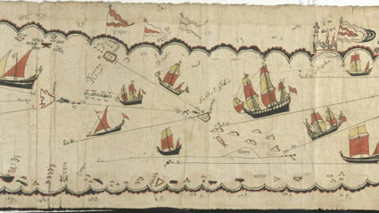
- A Gujarati chart of the Red Sea, produced in the 17th century and collected by an East India Company officer in 1835;
- A collection of copied and traced ‘native’ maps from colonial Burma produced in the 1870s;
- And a Tibetan map of Sikkim used by the Tibetan military and seized by the British authorities in 1888.
Find out more
An article about Joy’s research and her archival trip to Delhi was published in the March 2019 edition of the Geographical Magazine.
A printed copy of this thesis is available for consultation in the Foyle Reading Room (reference only). You can also access an electronic copy on Royal Holloway.
Starting references
- Bassett, T. J. (1998) “Indigenous mapmaking in intertropical Africa,” in Woodward, D. and Malcolm Lewis, G. (eds) The History of Cartography, Volume 2 Book 3, Cartography in the Traditional African, American, Arctic, Australian, and Pacific Societies. Chicago: The University of Chicago Press, pp. 24-48.
- Belyea, B. (1992) Amerindian Maps: The Explorer as Translator. Journal of Historical Geography, 18: 267-277.
- Craciun, A. (2013) Oceanic Voyages, Maritime Books and Eccentric Inscriptions. Atlantic Studies, 10: 170-196.
- Di Piazza, A. and Pearthree, E. (2007) “A new reading of Tupaia’s chart,” Journal of the Polynesian Society, 116(3), pp. 321-340.
- Driver F. and Jones, L. (2009) Hidden Histories of Exploration: Researching the RGS-IBG Collections. London: Royal Holloway/RGS-IBG.
- Edney, M. (1997) Mapping an Empire: The Geographical Construction of British India, 1765-1843. Chicago: University of Chicago Press.
- Harley, J. B. (2001) The New Nature of Maps: Essays in the History of Cartography. Baltimore and London: The Johns Hopkins University Press.
- Lyons, H. (1928) “The Sailing Charts of the Marshall Islanders”, The Geographical Journal, 72(4), pp. 325-327.
- Konishi, S., Nugent, M. and Shellam, T. (2015) Indigenous Intermediaries. Canberra: ANU Press.
- Raj, K. (2006) Relocating Modern Science: Circulation and the Construction of Scientific Knowledge in South Asia and Europe. Basingstoke: Palgrave Macmillan.
Key sources
- Map collection: the Society's map collection contains over a million maps (manuscript and printed), atlases and globes representing most parts of the globe. It is fully catalogued at item level and can be searched in the Society’s online catalogue. While most of the maps date from 1830 onwards (1830 was the founding year of the Society), the oldest printed cartographic item dates back to 1485.
- Map accessions register: in many cases, the online catalogue does not provide much information about why and how a map came into the Society’s collection. Sometimes, the accessions register provides information, for example about the donor of a specific map. The accessions register is comprised of a series of books, listing the maps chronologically as they came into the RGS.
- The Geographical Journal: This is the Society’s Journal, published since 1830. It is a great source for understanding the development of Geography as an academic discipline and the Society's involvement in it. It frequently contains fold-out maps. The Journal is available online through JSTOR or on the shelves of the Foyle Reading Room at the Society.
- Photography collection: this large collection (over half a million images) dates from 1830 onwards and depicts a great variety of places and people, providing context to many of the maps in the Society’s collection.