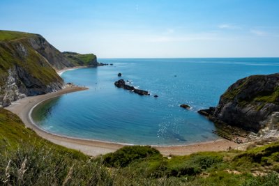
20 years, 95-miles, 185 million years: a celebration of the Jurassic Coast
The purpose
The Jurassic coastline stretches from Exmouth in East Devon to Studland in Dorset. Although it is called the Jurassic Coast this coastline contains fossil and geological evidence from the Triassic, Jurassic, and Cretaceous periods.
In this resource we will examine some of the key features which make this coastline so special.
The coastline covers the Dorset and East Devon Coast and in December 2001 received special UNESCO World Heritage Site status — the first ever natural World Heritage Site in England. The site consists of 155-kilometres of cliffs, beaches, bays, spits, tombolos, caves, arches, stacks, and stumps. The area begins in Orcombe Point, in the west, and ends at Old Harry Rocks, to the east. If you were to walk from west to east it would essentially be ‘a walk through time’ as you would be moving from the Triassic period (250-200 million years ago) through to the Cretaceous period (140 to 65 million year ago). Because this coastline offers such a unique insight into the Earth Sciences it is a popular protected natural wonder. Figure 1 below illustrates how the story of the Jurassic Coast began 250 million years ago.
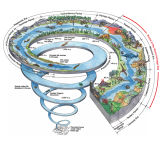
Figure 1 Our Earth History © The Jurassic Coast
In order to understand more about the Jurassic Coast, watch our School member lecture from Dr Anjana Khatwa: 20 years, 95-miles, 185 million years: a celebration of the Jurassic Coast World Heritage Site.
You can also download our free teaching resources on the Jurassic Coast of Dorset and East Devon.
Specification links
AQA
3.1.3.3. Coastal landform development. The relationship between process, time, landforms, and landscapes in coastal settings.
Edexcel
2B.1 The coast, and wider littoral zone, has distinctive features and landscapes. Coasts can be classified by using longer term criteria such as geology and changes of sea level or shorter-term processes such as inputs from rivers, waves, and tides.
OCR
2. b. Coastal landforms are inter-related and together make up characteristic landscapes. Case studies of a high energy coastline (such as rocky) to illustrate the physical factors which influence the formation of landforms within the landscape system, the inter-relationship of a range of landforms within the characteristic landscape system and how and why the landscape system changes over time from millennia to seconds, such as cliff collapse in seconds, seasonal changes in beach profile and spit growth over millennia.
Eduqas
1.1.8 Variations in coastal processes, coastal landforms, and landscapes over different time scales. Process and landform and landscape changes over millennia either eustatic or isostatic changes in sea level and their impact on one landform.
The geology of the World Heritage Site
The Triassic, Jurassic and Cretaceous periods all fall in the Mesozoic Era. The three periods are summarised below, with explanations about how the landscape has been influenced.
-
Triassic Period: occurred 250 to 200 million years ago. From rocks in desert-like conditions. At this time, the coastline was a part of the super-continent Pangaea. The conditions were arid. The first dinosaurs evolved with most of the living groups of four-legged animals arriving.
-
Jurassic Period: ran from 200 to 140 million years ago. This marked a period of sea level rise. Ammonites and marine reptiles were the dominant species. Clays, sandstones and limestones are deposited as Pangaea starts to break apart. It is more Caribbean-island-like.
-
Cretaceous Period: dates from 65 million years to 1.8 million years ago. Sea levels drop and rocks form in swamps, forests and lagoons. Importantly Earth movements tilt the rocks to the east (i.e. rock formations drop in the east with erosion above removing Triassic rocks there).
Figure 2 (in the downloads box) shows the awe-inspiring history of this coastline. The whole Mesozoic Era (spanning around 185 million years) is in evidence with ancient fossils and geologically important rocks from the Triassic, Jurassic, and Early Cretaceous periods on show. The Mesozoic Era was characterised by the rapid evolution of life on the Earth and has created ‘the great unconformity’ of a time gap between rocks of a different age, running right across the Jurassic Coast.
-
Study Figure 2 (download from the downloads box) showing the Triassic, Jurassic, and Cretaceous rocks. Using this ArcGIS map label Lyme Regis, West Bay, Chesil Beach, the Isle of Portland, Lulworth Cove and Swanage.
Sidmouth
2021 marks the 20-year anniversary of this beautiful coastline being a UNESCO world heritage site. The coastline is a unique geological landform:
-
It is one of 1121 world heritage sites across the world (of which there are only 213 natural)
-
Within these numbers only 83 are geological sites
Sidmouth is a place of red rocks capped by yellow Upper Greensand and white Chalk. In this part of the coastline the Jurassic rocks have been completely eroded away creating the ‘unconformity’ between ancient Triassic rocks and the much younger Cretaceous rocks. Locally the Cretaceous Upper Greensand, which forms the cliff tops in the photograph below, is called ‘Salcombe Stone’. It has been used in the construction of Exeter Cathedral.
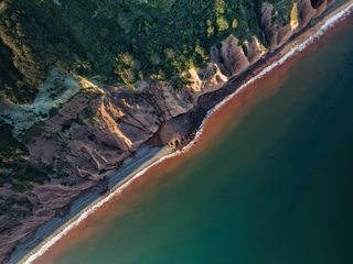
Figure 3 an aerial view of cliff collapse at Sidmouth © Red Zeppelin
Black Ven
Figure 4 shows Black Ven at Lyme Regis. It is a landslide site — the largest coastal landslide in Europe. It is an important site along the Jurassic Coast. It is made up from clays, shale and limestone. It is an excellent example of 2 critical processes acting on the landscape. Firstly, physical weathering which begins with rains filtering down through the clays to reach the limestone and ultimately destabilizing the entire mass. The second process is erosion by the sea which is eroding the foot of the slope again weakening the structure of this particular part of the coastline. The landslide is significant because an enormous amount of debris is being released from the slope, in turn exposing a huge variety of ancient fossils.
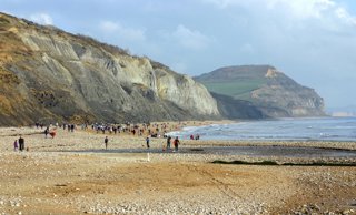
Figure 4 Black Ven landslide © Kevin Walsh
Mary Anning (1799-1847) who is described as ‘the greatest fossilist who ever lived’ collected fossils around Black Ven and Lyme Regis nearly 200 year ago. Professional fossil collecting remains an important part of the World Heritage Site to this day with new finds still being reported by local collectors. Recently a 3-metre skeleton of a Scelidosaurus was discovered, making it one of the best examples of the Thyreophoran dinosaurs which means ‘armored dinosaurs. The Scelidosaurus is described as one of the ‘big five’ of the Jurassic Coast and is found nowhere else in the world. The 1-mile stretch of coast between Lyme Regis and Charmouth is the only place a handful of specimens have ever been found.
Charmouth
The rocks that make up the cliffs of Charmouth are special because they are rich in fossils of the animals that swam in the Jurassic seas. Due to the rapid erosion of this part of the coastline there are thousands of fossils are revealed, especially after severe winter storms. The cliffs are bulging with fossils making Charmouth Beach one of the most popular fossil-collecting sites in the UK.
Common finds are ammonites, belemnites, or possibly even a fragments of ichthyosaur bone. If you visit the beach, make sure you go to the Charmouth Heritage Coast Centre to get a close look at some amazing fossils. Here you will be walking in the footsteps of Mary Anning as Charmouth was her hometown. It is important for any fossil hunter visiting Charmouth to follow the fossil collecting code.
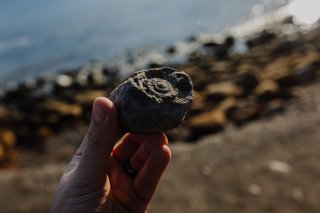
Figure 5 Fossil hunting © Phil Hearing
Worbarrow Bay
Worbarrow Bay is roughly 1.5-miles to the east of the famous Lulworth Cove. It is surrounded by high cliffs with a cleft (a narrow dent in the landscape) at the centre of the bay. This distinctive V-shaped centre is called Arish Mell Gap. Worbarrow Bay is another interesting location because it highlights the complexities of managing a World Heritage Site with multiple landowners. Worbarrow Bay is in the middle of the Lulworth Gunnery Ranges with the surrounding land being owned by the Ministry of Defense. Because Worbarrow Bay can only be visited when the Lulworth Gunnery Range is not in use by the armored fighting vehicles thereby limiting access to the public. The use of this land as an army firing range emphasizes the pitfalls and challenges of making the Jurassic Coast accessible to all. The largest stakeholder is the National trust, who manage one-third of the Jurassic Coast.
Worbarrow Bay is an impressive place with wealden clays ‘straddlingly’ the Jurassic-Cretaceous boundary with chalk and portland stone from the Jurassic Period.
-
Go back to Figure 2 (from the downloads box). Using this Earth magazine map annotate where Sidmouth, Charmouth and Worbarrow Bay.
-
The geologically age of the rocks across the Jurassic Coast is spectacular. Using the geological descriptions (within the download document), correctly annotate Sidmouth, Charmouth Beach, and Worbarrow Bay onto Figure 2.
Questions for the School member lecture from Dr Anjana Khatwa
-
What does UNESCO stand for and what do we mean by the assigned status?
-
Why is the Italian city of Florence an example of a UNESCO world heritage site?
-
What is the reason for the Cornwall and West Devon Mining Landscape?
-
Why do places like Hiroshima and Auschwitz also have UNESCO protection?
-
If you were hiking along the coast, in which direction would you ‘be walking through geological time’?
-
Durdle Door, Lulworth Cove, Swanage and Old Harry Rocks are all well-known coastal features, what does Anjana say about Black Ven?
Further reading
This resource was based on the Dorset and East Devon World Heritage Coast Trust’s book The Official Guide to the Jurassic Coast: a walk through time, which received a Highly Commended award from the Geographical Association.
-
20 years, 95-miles, 185 million years: a celebration of the Jurassic Coast World Heritage Site
-
What Does UNESCO Recognition Mean, Exactly? - The New York Times (nytimes.com)
-
Charmouth - East to Stonebarrow Hill, Dorset, UK - Geology Field Guide (soton.ac.uk)
Answers for the School member lecture from Dr Anjana Khatwa
-
UNESCO stands for the United Nations Educational, Scientific and Cultural Organisation. If a site is given UNESCO assigned status that means it is of value and benefit to humanity, and should be protected. These sites are described as a part of our ‘world heritage’.
-
The birthplace of the renaissance — every site must demonstrate an outstanding universal value.
-
It is to do with the genius of the technology that allowed for the extraction of tin and lead. The technology transformed mining all over the world.
-
They mark a failure in human behavior and history. These places are preserved to ensure we never forget these moments in time.
-
If you were walking from west to east you would be walking over Triassic rocks, followed by Cretaceous and then Jurassic rocks.
-
Black Ven is a remarkable landform. It is the biggest coastal landslide in Europe with the mudslide tongues stretching out into the sea. It is an example of a complex rotational failure.
- Podcast
Dr Anjana Khatwa and the UNESCO World Heritage Jurassic Coast
Talking fossil hunting, geology and landslides on this UNESCO World Heritage coastline
- Fieldwork
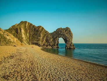
Jurassic Coast of Dorset and East Devon
The Jurassic Coast of Dorset and East Devon is a 95 mile stretch of coastline that demonstrates 185 million years of geological history
- Lecture
A celebration of the Jurassic Coast - Dr Anjana Khatwa
School Member lecture, 1 February 2021
This resource was first published in 2021.