Specification
AQA 3.4.1 Qualitative skills and quantitative skills. Understanding of what makes data geographical and the geospatial technologies (e.g., GIS).
OCR 4. Geographical Skills. Understand the opportunities and benefits of presenting and analysing geographical data through the use of Geographical Information Systems (GIS).
Edexcel Geographical skills understand what makes data geographical and the geospatial technologies (e.g., GIS).
WJEC Using geographical skills. Some secondary information must also be included in the independent investigations; for example, from background reading, satellite images, aerial and oblique photographs, large databases and GIS.
Flyways
The world is split up into 8 or 9 flyways. Migratory birds use them to find resources such as food, and to access favourable climates for survival and breeding.
Flyways are superhighways. They are important flight paths which migratory birds use either for short migration or very long intercontinental journeys. The osprey flies north-south in the East Atlantic flyway, coloured pink in Figure 1. This flyway goes from the Russian Arctic, Greenland, and Iceland, all the way down to Africa. The UK has a really important role along this route as it is situated in the middle of the flyway.
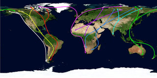
Figure 1 the world’s migratory flyways © The Science Photo Library
The East Atlantic flyway is particularly important for the osprey because it relies on coastal and fresh water along the edge of Europe and Africa for feeding. It also needs healthy forests as it migrates because it perches on treetops. The osprey is often seen nesting in wetlands. These landscapes are increasingly under threat and must be conserved to protect migratory birds.
It still isn’t fully understood how ospreys navigate, particularly as osprey chicks undertake their first migration all the way to Africa without any guidance from their parents.
Possible explanations for this remarkable journey include:
- They are born with a migratory route and are pre-programmed giving osprey chicks an innate understanding of the migratory superhighway
- They learn from other experienced ospreys, absorbing cultural cues, learning by rote.
- They use environmental clues to guide them, such as the wind, the sun, temperature, even the Earth’s magnetic field.
Due to this lack of understanding, and the growing twin threats of climate change and habitat destruction, a unique conservation project has begun, called Flight of the Osprey.
Flight of the Osprey
In this groundbreaking new approach to conservation, which Sir David Attenborough described as ‘marvellously imaginative and adventurous’, Sacha Dench and her team tracked and accompanied the osprey on its autumn migration from the UK to Guinea in West Africa.
The project collected vital data on the threats to this iconic fish-eating bird of prey. The research has gone hand in hand with other UK conservation efforts and has dramatically raised the profile of the osprey and other UK migratory birds. In 2021, for the first time in over 150 years an osprey chick was born in England. You can find out more at Conservation Without Borders.
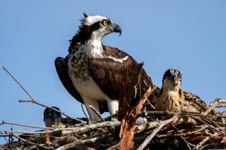
Figure 2 an osprey and her chicks © Joshua J. Cotton Unsplash
The RSPB identify the osprey as ‘resident’ in the UK during summer, between March and October. Key nesting sites are found in the Midlands, North Wales, and across Scotland.
Activity
Access the ArcGIS map which tracked ‘Glen the osprey’ from his nesting site in Cardrona Forest, just south of Edinburgh, to the low flat Maghreb of Western Sahara.
- Access our ArcGIS map of the journey Glen flew in 2022. You can explore the map, and add layers, without signing in. To save your work, sign in before creating your map
- Go to the add button in the top left of the display ribbon ⊕ go to Add media layer and search for a global biome layer under the Living Atlas catalogue, titled RESOLVE Ecoregions and Biomes. Add it to your map. In October, what biome is Glen flying from and to?
- Now search for and add Land Cover 2050 – Global. Click the three dots beside the data layer and select Add to base layer. How will the environment along Glen’s flight path change?
The index to land cover values for the Land Cover 2050 – Global dataset are:
01 Mostly Cropland
02 Grassland, Scrub, or Shrub
03 Mostly Deciduous Forest
04 Mostly Needleleaf/Evergreen Forest
05 Sparse Vegetation
06 Bare Area
07 Swampy or Often Flooded Vegetation
08 Artificial Surface or Urban Area
09 Surface Water
10 Permanent Snow and Ice
Remember you can bring layers either forwards or backwards by clicking the eye icon to hide a data layer.
If you do this for the RESOLVE Ecoregions and Biomes layer you will be able to compare the biome map for today against 2050.
Further reading
- Flight of the Osprey Conservation Without Borders
- The Flight of Osprey YouTube trailer
- Scottish Wildlife Trust Osprey fact file
- Purpose-built platforms on the Bolton Castle Estate Sacha Dench discusses Flight of the Osprey on BBC Breakfast 7 Aug 2022
- Birdfact Are the Ospreys endangered?
- The Guardian Ospreys make triumphant return as breeding pairs spread across UK
- ITV News Hundreds of osprey chicks return to the sky at Rutland Water after extinction risk
Answers
2. His journey takes him from the temperate broadleaf and mixed forests of the Scottish Borders, and Galicia on the Iberian Peninsula, to the dry arid desert of north Africa.
3. In 2050 the Scottish Borders will see a reduction in mixed conifer woodland and an increase in grass, scrub or shrub. As Spain is in the Mediterranean, a climate change hotspot, these effects will be more pronounced. In Western Sahara the dry desert will develop severe xeric conditions. In the data layer the north Africa region where Glen lands is described as a ‘bare area’ by 2050.
File nameFiles
File type
Size
Download