Map skills Year One
In this lesson pupils learn that maps and plans are representations of space in two dimensions and flat images
The main activity involves pupils creating a plan of their classroom, thinking about the relative position of different objects in the room, and representing 3-D space in a 2-D diagram.
Key questions
What is a map?
What is a plan?
Where would we find them?
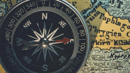
What are compass points?
How can we use them to give directions?
Key Ideas
Maps and plans are views from above or a ‘bird’s eye view’ of a place and use symbols.
Maps and plans show the distance between places or objects accurately, through using a map scale.
They can be drawn at different levels of detail: from the positions of objects in a room (a plan) to the location of countries, continents and oceans in the world (a world map).
There are four main compass points which help people to navigate direction: North, South, East and West.
Additional resources
-
A range of maps on pupils’ desks (tube, OS, road atlas, bus map, cycle route map etc.)
-
Camera/prepared photos of the classroom
-
Rope to create a large outline of the classroom
-
Compass
-
Class toy
-
Paper and pens for drawing plans
Learning Objective
To create plan of the classroom.
Starter
Show pupils a variety of different maps, plans and globes. These could include floor plans, hug-a-globes, bus and train maps, street maps, atlases, plans of the school, Google Earth, Satnavs and any others available. Let them look and touch them all. Ask them what do they think people use maps for? Are maps they flat or round?
Main Activity
Ask pupils to say what they could see on the maps, plans and globes. Pose the questions:
-
Have you seen anything like this before?
-
Where have they seen them?
-
What can you see on the maps?
-
Record what the pupils say as a formative assessment and these can be added to a working wall.
As a whole class, pupils create a plan of the classroom. Either show pupils prepared photos taken at a range of locations within the classroom or take photos with pupils prior to the lesson in small groups.
Place a large outline of the classroom on the carpet using rope and define key places in the classroom such as the windows and entrance. With the pupils sitting around the edge, ask them to arrange the photos so they are in the right place. Tell the class that they have created a plan of the classroom.
Explain the compass points using the PowerPoint presentation. Give directions using compass points e.g. the carpet is south of the desk. The pupils then use this information to draw the compass point North on the plan and point to the compass directions in the classroom. Show pupils how direction can be discovered using a basic compass.
Pupils then begin an independent activity, and create their own plan of the classroom, marking on key objects and features of the room, using the examples on the PowerPoint presentation as a guide.
Extension: pupils can move on to creating a plan of the school hall, using photos or pictures as a starting point.
Plenary
Pupils share and compare their plans of the classroom, and discuss how they represented distance and direction on their plan.
Play ‘Toy Detectives’: a member of the class leaves the room, whilst a volunteer hides a class toy and another pupil marks its location on the classroom plan. The child then returns and uses the map and ‘x marks the spot’ to find the hidden toy.
Further study
This lesson could be followed up by more map making. Pupils could mapping a route around school or around the playground. They could also use ‘beebots’ as part of a linked computing lesson to further explore distance and direction in the classroom before marking a beebot route on their classroom plan.
File nameFiles
File type
Size
Download