GCSE specification links
AQA
Weather hazards including extreme weather in the UK, evidence that UK weather is becoming more extreme, and a case study of a recent extreme weather event
Pearson Edexcel A
Weather and climate hazards, climate change, and extreme weather events within the physical environment component
Pearson Edexcel B
Hazardous weather, climate change, and extreme weather impacts and responses
OCR Geography A
A study of weather hazards and extreme weather
OCR Geography B
Extreme weather and impacts
WJEC Eduqas A
Weather, climate change and hazardous or extreme weather events
WJEC Eduqas B
Weather hazards, climate change and extreme weather impacts
CCEA
Extreme weather and the processes shaping our weather
Introduction
The ENSO
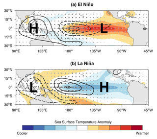
El Niño and La Niña are two climate phases of a natural cycle called the El Niño–Southern Oscillation (ENSO). They bring contrasting weather patterns over the Pacific Ocean.
Warmer-than-average or colder-than-average ocean temperatures can influence weather around the globe.
This is especially true for the Pacific Ocean, which is the largest ocean on Earth, covering about 165 million km2 and accounting for more than 30% of the surface of the planet.
La Niña is generally thought of as closer to a ‘normal’ state of the Pacific Ocean. During normal conditions, trade winds blow from east to west, pushing warm surface waters towards Asia. This warm surface water builds up in the western Pacific, it typically ‘piles up’ near Indonesia. Associated rainfall is usually concentrated in this area around Indonesia, the Philippines and Malaysia.
Strong trade winds are a signature of La Niña. During a La Niña event unusually cold conditions build in the central and eastern tropical Pacific, which displaces the jet stream northward.
The Pacific has recently undergone a periodic phase transition from La Niña to El Niño.
As a result of this climate system shift to El Niño, there is an increased likelihood of global temperature records being broken, raising the risk of droughts, floods, heatwaves, and disruptive weather patterns in many regions around the world.
El Niño
A super El Niño is a naturally occurring climatic phenomenon that forms when sea surface temperatures in the central and eastern Pacific Ocean (near South America) become warmer than average.
The current 2026–2027 El Niño began developing last spring and was formally declared by the National Oceanic and Atmospheric Administration (NOAA) in June 2026. It is expected to end in spring 2027. It is being described as a ‘super’ El Niño because of weakened trade winds, extreme sea surface temperatures and record-breaking strength. The extra energy is attributed to human-driven climate change.
During a super El Niño event, trade winds weaken, allowing warm water to spread eastwards across the Pacific.
This shift alters atmospheric circulation patterns and changes weather conditions around the whole world. Super El Niño events are often associated with increased rainfall in western South America and drier conditions in Australia and Southeast Asia.
| Indo-Australia (in the western Pacific) | The Americas (in the eastern Pacific) |
| Reduced trade winds allow warm water to shift | Warmer air shifts eastwards |
| Hotter and drier | Warmer and wetter conditions in Peru and Ecuador |
| Increased risk of drought | Increased risk of flooding and landslides |
| More bush fires | A study of weather hazards and extreme weather |
| Fewer tropical cyclones near Australia | Heavier rainfall and violent storms |
| Lower river flows and reduced agricultural productivity | Increased agricultural productivity in some normally arid coastal regions |
Table 2: Summary table of weather from Super El Niño
Read more about Super El Niño with the following online articles:
BBC What is El Niño? – record temperatures predicted
BBC Super El Niño sets another record as it strengthens to 'unprecedented levels' – historic data
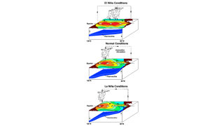
- The left side of each diagram is the western Pacific Ocean, near Asia, and the right side is the eastern Pacific Ocean, near South America.
- Red/orange colors indicate warm ocean surface temperatures, yellow/greenish colors indicate cooler temperatures.
- The blue band is the "thermocline", approximately the location of water that is about 20ºC (50ºF).
- Rain clouds form over the pool of warm water.
During El Niño, the warm pool of water moves eastward and the slope of the thermocline flattens.
During La Niña, the warm pool moves westward, and the slope of the thermocline steepens.
Impacts
Impacts on global weather patterns
One of the biggest impacts of the super El Niño is the change to rainfall patterns across the world. In regions such as Australia, Indonesia, India, and southern Africa there will be below-average rainfall and drought conditions. These unusually dry conditions can reduce water supplies, increase the risk of wildfires, and damage agricultural production.
During 2026 Indonesia has been battling its worst wildfire season since 2015. Over the first 10 months of 2026 Indonesia has lost 895,657 hectares of land due to wildfires – twice as much as normal. The smoke has caused severe health problems from haze and air pollution, with hundreds of thousands of respiratory illnesses among the young and elderly, particularly in Sumatra and Kalimantan.
The wildfires have caused environmental damage and increased greenhouse gas emissions from destroyed tropical forests, peatlands, and wildlife habitats. This incineration significantly contributes to global climate change and threatens endangered species, such as orangutans.
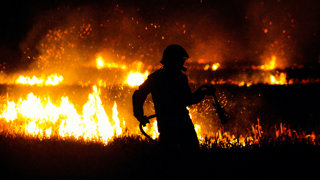
Indonesia has suffered economically from these extreme fires. Smoke has created poor visibility which has produced a dangerous haze delaying international flights and disrupting transport across the country. Huge swathes of agricultural land have been burnt and will not be viable for harvest, reducing agricultural productivity. As the world’s leading producer of palm oil (Indonesia produces around 60% of the world's palm oil) a reduced palm oil crop could have significant global impacts, causing higher food prices and increased pressure on other alternative oils such as soybean oil or sunflower oil.
In contrast, countries on the western coast of South America, particularly Peru and Ecuador, often receive much heavier rainfall than usual during El Niño, leading to flooding and landslides.
A super El Niño has major impacts on Peru because it lies on the eastern edge of the Pacific Ocean where sea temperatures are becoming unusually warm. Throughout 2026 and 2027 increased evaporation will lead to much heavier rainfall, particularly along Peru's northern coast. This will cause severe flooding and landslides (eroding fertile soils). As a result, extensive damage to homes, roads, and infrastructure is anticipated.
Peruvian agricultural land may be inundated, reducing crop yields and disrupting food supplies. Crops such as rice, sugar cane, and vegetables are particularly vulnerable. Crop disease is a major concern. Warm and wet conditions encourage fungal diseases and pests, which could affect crops such as coffee, grapes, and fruit.
Along the Peruvian coast warm ocean waters will reduce the upwelling of nutrient-rich water. This will have an impact on the marine industries as fish populations, such as anchovies, decline. As Peru has one of the world's largest fishing industries, a decrease in fish stocks can significantly affect employment, exports, and incomes for coastal communities.
A super El Niño also influences global temperatures. The release of heat from the Pacific Ocean into the atmosphere typically raises average global temperatures, making this year among the warmest on record. Higher temperatures can intensify heatwaves in many parts of the world, placing stress on ecosystems, infrastructure, and human health.
The phenomenon affects atmospheric circulation and the position of the jet streams, which influence the movement of storm systems. As a result, some regions may experience more frequent storms, while others encounter prolonged periods of settled weather. Tropical cyclone activity is also altered, with fewer Atlantic hurricanes generally occurring during super El Niño years, while cyclone activity in parts of the Pacific may increase.
Read more about Indonesia and Peru in the following articles:
Reuters Indonesia's fire hotspots ease but rain still not enough, official says – respiratory illnesses
Guardian ‘The physical toll is visceral’: How Indonesia’s fire haze affects millions – a visual guide
BBC Why is a peat fire so bad? – explanation on why peatland fires are so difficult to contain
Reuters Super El Niño puts 1.2 million people at risk in Peru – preparation of “critical points”
RGS-IBG Super El Niño and Development in Peru – management to minimise impact
Guardian How the super El Niño is devastating the fishing industry – economic disaster
Impacts on UK weather
Changes in the Pacific Ocean and the strengthening the super El Niño are linked to the North Atlantic Oscillation (NAO), a weather pattern that involves differences in air pressure over our nearby Atlantic Ocean. During the autumn in the UK there may be wetter weather. A stronger Atlantic storm track can bring more frequent low-pressure systems, leading to periods of heavy rainfall and an increased risk of river flooding.
This is because from October to December 2026, there is an increased chance of the UK experiencing stronger westerlies (prevailing winds from the west) and low-pressure patterns which are associated with increased storminess and an increased risk of heavy rainfall and flooding.
Ultimately, this will saturate UK soils and might further increase flood risk in vulnerable areas.
In late autumn and early winter, there will be more storms. In October, Storm Austen and Storm Boelo have already both triggered amber wind warnings. This stormy and wet weather is due to the super El Niño affecting the stratospheric polar vortex (over the North Pole).
Changes to the vortex disrupt the jet stream (the high moving body of air that drives much of UK weather) increases the likelihood of storms and wetter weather.
After this unsettled period, one likely impact is a colder and calmer season in late winter. This is because changes to the NOA might bring weaker winds from the Atlantic Ocean to the UK.
In early 2027, as a result of the earlier vortex weakening, there is a slightly increased risk of easterlies and northerlies and ‘cold snaps’ (sudden temperature drops).

Read more about UK weather in the following articles:
Conversation A record‑breaking Super El Niño is still developing – bringing a cold winter to the UK
GOV.UK Research and analysis Impacts of El Niño on the UK – weather and UK food supply chain
BBC Stormy autumn, cold winter – how the El Niño might affect UK weather
House of Commons What might a ‘Godzilla’ El Niño mean for the UK? – UK impacts
Impacts on food
Global food production will be significantly affected by the super El Niño.
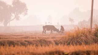
In Australia, the Super El Niño typically reduces winter and spring rainfall and there is a sharp drop in production of major winter crops like wheat, barley, and canola. Australian livestock also struggle as drier conditions lead to lower pasture availability (reduced availability of fields of grass) and as such farmers are forced to buy feed supplements. Alternatively farmers begin culling their herds to prematurely reduce stock numbers.
The Australian beef industry is vital to the country’s economy, accounting for 50% of Australia’s landmass, with 28 million cattle and accounting for thousands of rural jobs. It is the world’s second largest beef exporter and exports alone are valued at US$11 billion annually. The total red meat industry turnover in Australia is US$50 billion a year.
In India there has been a similar drop in production of rice due to monsoon rainfall already being 13% below average. Across central India rainfall levels are expected to remain consistent but in the east and north-east it has been around 26% drier than average with some areas already experiencing exceptional drought. The southern states of India were also 24% drier than average. This is significant because eastern states such as West Bengal, Bihar and Assam are the heartland of Indian rice production (West Bengal is India's largest rice-producing state). Consequently, more stress and vulnerability will afflict agriculture yields in the region. The monsoon deficit will negatively impact India’s rice production with lower yields and output, and reduced acreage.
There are several risks to UK food security from the super El Niño, as the country imports around 50% of all food (including larger vulnerability such as importing 80% of fruit and vegetables).
Global harvests are forecast to reduce over the coming year. India, Thailand, and Vietnam may experience lower rice yields and exports. Whilst coffee and cocoa producing countries will struggle as these commodities are unfortunately concentrated in only a small number of countries. This is expected to lead to higher UK food prices showing how climate impacts overseas can quickly affect UK consumers.
Read more about the impact on food production in the following articles:
BBC Five ways Super El Niño is affecting the weather around the world – reduced monsoon rain
GOV.UK Research and analysis Impacts of El Niño on the UK – weather and UK food supply chain
University of Oxford Are more food price increases on the way from El Niño? – what we should do
UN WFP How does El Niño affect hunger and how does WFP respond? – where it will hit hardest
Conversation How El Niño could push up your mortgage and grocery bills – food security
Impact on energy systems
The colder, calmer weather expected in the UK in late winter will be a challenge for energy production. Over the past two decades the UK has been scaling up renewable energy. In 2024 UK renewable energy accounted for 50.4% of total electricity generation, surpassing fossil fuels for the first time and setting a new national record.
Wind power can generate 40%+ of the UK’s electricity during winter. If the UK experiences a less windy winter, renewable energy production may fall, especially if conditions are also cloudy (impacting solar generation).
A calm winter period therefore requires more liquified natural gas (LNG) power to support increased seasonal demand for heating and to make up for lower wind generation.
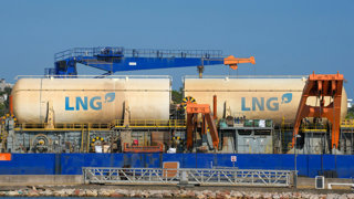
A colder and drier late winter will increase demand for LNG. The trade of LNG is unfortunately at an all-time high due to the war US-Israeli-Iran war and, in particular, the closure of the Strait of Hormuz, which has constrained 20% of global LNG flow.
The UK will therefore have to compete with numerous other countries for highly sought after LNG, including China and Japan.
However, this shortfall will be mitigated by UK energy reserves. Over the super El Niño period the UK government forecasts a secure amount of electricity, with an 8.8% buffer of electricity.
Significantly, this is higher than the 2022 energy crisis, due to sufficient gas reserves and the increased availability of French nuclear energy.
Read more about the impact on energy systems with the following online articles:
Met Office An ‘unprecedented’ El Niño – what an unprecedented El Niño could mean for the UK
British Red Cross Super El Niño and the UK – impact on UK weather
Chatham House A 2026 ‘super El Niño’ could expose gaps in UK preparedness – risks for UK
Forbes What Super El Niño Means For Business Supply Chains And Economy – market disruption
Questions
- What is the ENSO cycle?
- Explain how a super El Niño develops.
- Why does a super El Niño affect weather globally?
- How has Indonesia been affected by the 2026 super El Niño?
- Why is reduced Indonesian palm oil production significant globally?
- Explain two impacts of the super El Niño on Peru.
- How might the super El Niño affect global food security?
- Why is Indian rice production particularly vulnerable during a super El Niño?
- How could the super El Niño affect UK weather during 2026-27?
- Explain one way a super El Niño could affect UK energy security.
Answers are provided in a separate document.
File nameFiles
File type
Size
Download
- Animation

Subject Knowledge Animation: El Nino and Development
An overview of the El Nino effect and its impacts upon development
- Article

El Nino and Development in Peru
Peru is regularly affected by El Niño and La Niña currents
- 60 second guide
El Nino and Development
A 60 second guide to El Nino and development.
This resource was first published in 2026.