What is an urban climate and how does it differ to a rural one?
An urban climate refers to the fact that the atmospheric conditions - the temperature, the humidity, the wind speed/direction, the air quality - tend to be different in a city compared to the surrounding rural environment.
The best known feature of an urban climate is the urban heat island; temperatures tend to be warmer in a city, particularly in the winter and at night. On average, urban temperatures may be one to three degrees centigrade warmer, but under appropriate conditions (calm, cloud-less nights in winter) air temperatures can be more than 10°C warmer than surrounding rural environments.
Other urban effects include poorer air quality, channelling of wind through urban canyons (the spaces between building), and increased rainfall downwind of cities.
Are there positive and negative effects of having differing climates in urban areas compared to rural areas?
Yes, as with most things it’s not all good or all bad - there are positive and negative effects of urban climates. Take the example of the urban heat island. Warmer temperatures in cities mean that in the summer during heat waves, many cities and their residents experience even greater temperatures and heat stress. In 2003 this was a major problem in Europe, particularly France, and many people died. However, in the UK in winter warmer temperatures in cities tends to reduce ice on roads, reduces the frequency of fog, and reduces the energy demand for heating. These are all positive effects. So, whether the effect is positive or negative depends on the city and the season.
Where and when did geographers first notice the impact of urban areas on their local climate?
The effects of cities on their climates have been known since Roman times. However, it was Luke Howard in London in the early nineteenth century who first collected systematic measurements of the climate in cities. In 1833 he published the second edition of his book ‘The Climate of London”. This volume is widely attributed as being the first to document urban climates and Luke Howard is commonly referred to as the first urban climatologist.
Since the 1970s there has been a significant increase in the number of studies of urban climates by geographers across the world. This is due to greater access to equipment to measure urban climate effects and also recognition of the large and ever increasing fraction (greater than 50%) of the world’s population that now live in cities. Thus it is of practical as well as scientific importance to know more about urban climates.
What are the major influences on urban climates?
Urban climates result from a combination of different factors. Ultimately urban climates result from changes in the exchanges of heat, momentum, water, and gases (like carbon dioxide) between the surface and the overlying atmosphere as compared with the pre-existing landscape. These changes occur because of the new materials that make up the urban surface, the morphology (shape) of buildings (compared to pre-existing forests, grasslands, deserts) and the additional emissions of heat and other gases by humans.
The materials that make up cities (concrete, brick, asphalt) are very different from the natural materials (soil, trees, grass etc) of pre-existing landscapes. The urban materials have different thermal and hydrological properties, which affect how the surface absorbs and stores heat and water. This means that more energy from the sun is absorbed by the urban surface and stored. This makes the surface warmer.
The morphology (shape) of the urban surface is also different from the pre-existing landscape. The walls and roofs of buildings – whether houses, factories, shops or parking lots - increase the surface area exposed at the surface which results in greater absorption of incoming radiation (energy) from the sun and affects the flow of air across the surface.
Direct emissions by urban residents; whether heat (from traffic, industry, the heating of buildings) or gases (carbon dioxide from burning of fossil fuels) or particulates (from industrial processes or traffic) all affect the urban atmosphere and the absorption and transmission of energy, and thus the weather and climate of cities.
What effect, if any, has the growth of cities had on the nature of the atmosphere?
At the global scale, cities only cover a small fraction of the Earth (approximately 2% of the land surface). Thus in terms of direct surface changes individual cities do not impact global weather or climate patterns. However, given the large and ever-increasing fraction of the world’s population living in cities (the majority of the world now live in cities), and the disproportionate share of resources used by these urban residents, especially in the global North, cities and their inhabitants are key drivers of global environmental change - whether greenhouse gas-induced warming, deforestation, desertification, or loss in biodiversity.
Cities affect both the sources and sinks of greenhouse gases both directly and indirectly. Urban areas are the major sources of human generated carbon dioxide emissions - from the burning of fossil fuels for heating and cooling; from industrial processes; transportation of people and goods, and so forth. While the exact number is debated, overall 70% to 90% of carbon emissions are generated in cities. Also, the clearing of land for cities and roads, and the demand for goods and resources by urban residents, both historically and today, are the major drivers of regional land use change, such as deforestation, which has reduced the magnitude of global carbon sinks
Are the characteristics of urban climates similar across the world or do they vary by location?
A city’s climate, and its effects on climate, is influenced by its geographical setting. Latitude has an influence through basic solar forcing (the amount of energy received from the sun); continentality influences seasonal extremes; and the sequence of expected fronts and pressure systems etc affect the range of meteorological conditions a city experiences. These all influence the design of a city (for example building styles) and behaviours and activities of inhabitants (demands for heating and cooling etc) and thus the specific urban climates that result. Thus urban climates vary from place to place as the factors that cause them – building materials, morphology of the surface, emissions by humans – also vary.
In high latitudes the direct emission of heat by humans (to keep buildings warm) tend to be greatest. In fact this source of energy may exceed that naturally coming from the sun. Under these conditions urban heat islands tend to be very well developed.
In arid environments, cities surrounded by deserts may actually be cooler than the surrounding rural landscape (urban cool islands). This is because urban residents plant gardens and water those gardens. Energy is used in evapotranspiration rather than heating the ground or air and temperatures are cooler.
At even the smallest scale, within a city, temperatures from one side of a street to the other, from a park to an industrial neighbourhood, or one suburb to another may be significantly different. These patterns are a function of urban morphology, built materials, amounts of vegetation and human activity.
So geography and scale matters and it is important to think about the key factors influencing the climate of a given city at a given time to be able to predict and understand urban climate effects.
Who is effected the most by urban climates, for example older people and homeless people and and what might be done to mitigate against this?
Those at most risk to the negative effects of urban climates, for example high temperatures/heat stress or poor air quality, tend to be those most vulnerable, the elderly, homeless people, or the very young. This is because they have pre-existing medical conditions that make them more sensitive or they do not have places to go (particularly at night) to escape the extreme heat. During the major heat wave in Europe in 2003, it was the elderly and homeless who had the highest mortality rates.
How is London’s urban climate being understood and responded to?
There are lots of studies of London’s urban climate – these take the form of measurements and computer based modelling.
The measurements document the nature of London’s climate – how it varies from place to place (spatially) and from day to day (temporally).
Computer models, developed for cities, and tested with data to make sure they are reliable, are used to predict future conditions and the effects of different mitigation strategies.
It’s nice and warm in Leicester square, can you explain why?
This is a classic example of the urban heat island effect; Leicester Square is right in the centre of London. Lots of traffic (buses and taxis) and people generating heat; tall stone and brick buildings absorbing lots of energy from the sun and trapping energy emitted by the surface; and very little vegetation or open water to use up (dissipate) any of this energy by evapotranspiration all are factors contributing.
What is an urban heat island and why does this occur?
Temperatures tend to be warmer in urban than surrounding rural areas, particularly when it is calm, clear and at night. These warmer temperatures in cities are referred to as the urban heat island. On average in cities temperatures are one to three degrees centigrade warmer, but on occasions may be as much as 10 C warmer.
There are many reasons why urban heat islands occur - the five main reasons are related to:
-
The building materials used to construct cities - bricks, concrete, asphalt etc. – have high heat capacities and ability to conduct heat. These materials absorb and store large amounts of heat in the day which is slowly released at night
-
The vertical walls and roofs of buildings increase the area exposed at the surface, further enhancing the absorption and storage of heat. They also reduce the ability for surface cooling - energy emitted from the surface is trapped in the urban canyons
-
The removal of vegetation and high impervious surface covers (parking lots, buildings, roads that don’t allow water to infiltrate) reduces water availability, limiting evapotranspiration. This means that available energy heats the building fabric and air; it is not used up evaporating water
-
Human activities release heat - from traffic, from factories, from homes (heating and air conditioning). This is an additional source of heat not available in rural areas
-
Air pollution. Human activities lead to ejection of pollutants and dust into the atmosphere; this may lead to retention of heat in the lower atmosphere
Can architects and planners minimise the formation or urban heat islands?
Yes. A wide range of strategies are used and are being considered to mitigate urban warming. The table below provides a summary; linking the strategies to underlying fundamental causes. The scales at which these can be applied vary; for example, individual building versus a neighbourhood, new development versus redevelopment /retrofitting.
Table one Causes of urban warming and examples of mitigation strategies
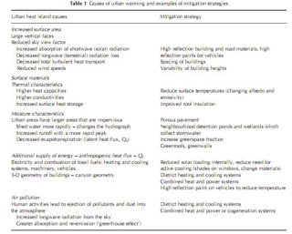
Table from Grimmond S 2007: Urbanization and global environmental change: Local effects of urban warming. Geographical Journal, 173, 83-88
Some mitigation strategies involve changing the material properties of individual buildings, others the spatial arrangement of individual buildings and vegetation.
Painting roofs and streets light colours or using different types of road or roofing materials, for example, increase the amount of incoming solar radiation that is reflected and thus not absorbed by the surface, resulting in cooling. This approach has been adopted in cities in hot environments (e.g. around the Mediterranean) for a long time. Changes in materials have the advantage that they can be used on current buildings, so do not require the costs or time of new development.
Planting vegetation, for example green roofs and/or creating parks, provides shade and thus localised cooling and, if there is enough water available, increases evapotranspiration which reduces the amount of energy available to heat the ground or air, also resulting in cooling. Think about the effects of sitting in the shade in the summer or walking through a park.
Many strategies benefit multiple aspects of urban environmental change. For example, the addition of water detention ponds and wetlands reduces peak urban runoff, which has the advantages of reducing the need to engineer larger systems to deal with flash floods and/or manage the release of untreated water downstream. With careful design of a wetland area, the quality of the stormwater can also be enhanced as well as providing the open areas of parks and enhanced evaporation. Additional social, cultural, and psychological benefits from ‘natural’ space can accrue too. Also, new residential developments that employ water-sensitive urban design that involves the use of grey water (reused water to irrigate residential vegetation reduces the demand for water to be diverted into a city for irrigation purposes).
Other strategies involve developing district heating and cooling (DHC) using combined heat and power (CHP) or co-generation systems. These aim to reduce the emissions of carbon dioxide and other air pollutants and have been developed for building to (small) citywide scales. Technological changes are increasing the viability of these systems; notably reducing energy losses in the transmission process, and by recapturing waste heat and energy to avoid warming the air unnecessarily. The captured heat can be used to meet heating requirements, provide cooling using advanced absorption cooling technology, and also to generate more electricity with a steam turbine.
Do urban planners take account of the effect of micro climates when planning urban spaces, for example do they consider the effect of wind blowing around buildings? Do jobs for urban climate consultants for example, exist?
Yes. Architects, planners and building engineers all consider the effects of climate on buildings and buildings on climate very carefully. Before construction begins on any tall building there will be extensive studies of the effects of wind flow through modelling and wind tunnel studies.
Urban climatologists work with architects, planners and engineers in the design new buildings and developments. They also work with regulatory bodies and local authorities setting requirements in terms of what types of buildings or developments can occur.
What are the major issues for urban planners and politicians in response to urban climates? How might future climate change impact on urban climates?
Urban areas already tend to be warmer than their rural counterparts and they are locations where very significant fractions of the world’s population live. Future climate scenarios, which predict an increase in summertime maximum temperatures and also in the frequency and magnitude of extreme conditions, suggest greater risks in the future.
Also, warmer conditions in cities may increase demand for air conditioning. More air conditioners generate more heat and have significant effects on the local-scale external climate, with implications for human comfort and the demand for cooling. At a larger scale, greater use of air conditioning results in more greenhouse gases through increased electricity generation. Therefore there are many benefits to trying to encourage design to make air conditioning use not needed.
Why should geographers be interested in this issue?
Urban climates bring together all the key elements geographers are concerned with – particularly the interaction between physical and human environments. There is nowhere that human impact on the environment is more widely and clearly defined.
The solutions to the negative effects of urban climates also lie with geographers and geography. Most of the world’s population now live in cities and in the developing world the rates of growth of cities exceed 200,000 people per day. Existing urban areas will experience redevelopment and refurbishment. The decisions made about how this will occur will impact upon the people living within the buildings, neighbourhoods and cities. In combination, they will have global implications and consequences.
Read the full article: Urbanization and global environmental change: local effects of urban warming. Published in Geographical Journal, Volume 173, Issue one, Pages 83-88
Sue was interviewed in February 2010.
Professor Sue Grimmond’s biography
Professor Sue Grimmond joined the Geography Department at Kings College London in January 2006.
She is a world leading expert on urban climates and serves in this role for a range of international bodies. These include the International Association of Urban Climate (IAUC); Lead Expert for the World Meteorological organisation (WMO) on Urban and Building Climatology and the American Meteorological Society (AMS).
Sue is the 2009 recipient of the Helmut E Landsberg Award from the American Meteorological Society 'for numerous important contributions that have greatly advanced urban meteorology and urban climate sciences, and for sustained and effective leadership that has energised the urban climate research community’.