The image of Lulworth that many people have is of a picture postcard fishing village nestled in the Purbeck hills. Old cottages and a thatched pub, with lobster pots in the Cove. Unspoilt by modern development and a place where time has stood still. This is also the image sold to the general public by tourist offices and hotels.
However, this village has not stood still. It was made popular by writers such as Hardy, and grew in popularity in the late 19th and early 20th centuries. Tourism developed, with both the car and caravan parks opening in the 1920s as a result of public demand.
Lulworth has managed to avoid the urbanisation that can be seen further east on the Dorset coast. Poole and Bournemouth used to be small villages on the heath, but have now merged into an urban conurbation. To understand why Lulworth still exists as it is, we must look at the history of the area.
Lulworth is part of a large estate, and the land area has been managed as a single entity for 1000 years. (For 400 years as two estates, and the last 350 years by a single family.) The Estate must generate its own income and therefore aims to move with the times and progress without detracting from the beauty of Lulworth. Lulworth has also been relatively isolated in terms of transport. The railway stops short of Lulworth and early visitors would have made the trip by paddle steamer from Swanage or Weymouth.
As the Lulworth area is largely unspoilt, in the last 50 years (since planning regulations were introduced), it has been covered by several designations to help protect the area and to conserve it for future generations.
Lulworth comes under:
-
World Heritage Coast
-
Area of Outstanding Natural Beauty
-
Site of Special Scientific Interest (Geology and Wildlife)
-
Conservation Area
-
Ancient Monuments
-
A Council of Europe Diploma Holding Area
Does such a small place as Lulworth really require management and conservation action? Its beauty, wildlife, good walking and a tendency to be mentioned in almost every geography text book means that Lulworth receives around 750,000 visitors every year. It is especially popular as an escape point from London and the South Eat as it is only two hours away by car.
The volumes of people visiting the area bring with them many positive aspects:
-
The local community and employment are sustained directly and indirectly through tourism revenue
-
Funds generated by tourism provide capital for investment at the Cove and for general Estate improvements
-
The Estate employs approximately 70 staff, of which about 30 are involved directly with tourism and leisure
However, so many visitors are not always desirable. There are many problems associated with tourism:
-
A large car park for vehicles
-
A caravan site for accommodation
-
Unsuitable or unsightly tourist shops
-
Erosion of footpaths
-
Pollution, rubbish and sewage
-
Erosion of Geological SSSI
The conflicts are clear. Lulworth provides a classic case study of countryside management needs with three main areas to consider:
-
The local community, economy and farming
-
The visitors
-
Conservation
To ensure that the character and amenity of Lulworth are retained, a sustainable balance between the three areas must be found. This may appear easy in theory, but it is not so easy in practice.
If we look at the major players which influence the area, we see that they are many and varied:
-
The Lulworth Estate
-
Dorset County Council
-
Purbeck District Council
-
The Ministry of Defence
-
The Council of Europe and other bodies influencing designations
-
The local community
The aims and requirements of each of the groups will vary according to their priorities, be it income, conservation or working policies.
So, what is actually happening on the ground towards better management in the Lulworth area?
In the 1990s the West Purbeck Warden wrote an assessment report on the management needs of the Lulworth area. The report contains information on:
-
Statutory designations
-
The physical environment
-
History and archaeology
-
Land use
-
Terrestrial ecosystem
-
Marine environment
-
Recreation and tourism
-
Visitor surveys
This creates a suggested basis for a broad management plan to tackle issues in connection with one another, and at the root of the problems. There is no sense in reviewing symptoms if the underlying cause remains the same.
The Heritage Coast plan cannot exist in isolation. It has to take into consideration the needs of all the aforementioned groups. Bringing everyone together at grass roots level and changing attitudes so that all groups are working towards a commend end is a lengthy process.
Management: Work done
Rangers
-
Footpath Management:
-
Rerouting
-
Reseeding
-
Geo-jute on loose areas
-
Signing
-
Hard pathway (around Stair Hole)
-
Stile counters
-
Step building
-
Improve access
-
-
Helpers in the effort to gain renewal of a Council of Europe Diploma
-
Interpretation
-
Boards
-
Leaflets
-
Guided walks and talks
-
Educational Displays
-
-
Screening
-
Looking at eyesore sites
-
The estate
-
Many of the above done with the involvement and cooperation of the Estate
-
There are a number of public rights of way (in effect created and consented to by the Estate) on the coastal area, but public access to other areas of the coast has been provided by the Estate for more than 100 years
-
The Estate have opened a number of permissive rights of way from the coast to the area inland and have also opened the Castle grounds which helps to reduce impact on the Cove area
-
An historic landscape survey produced
-
Involvement of tenant farmers in the Countryside Stewardship Scheme
Wessex Water
Have recently completed a scheme to screen all sewage before discharge.
The Purbeck Heritage Committee
This committee was created to examine problems on the Heritage Coast as a whole. It was formed in 1993 and brings together representatives from conservation, landowners, tourism and local government to co-ordinate the activities of the many bodies involved in managing, conserving and enjoying Purbeck.
The committee has recently published the Strategy for the Purbeck Heritage Area.
Management: Future issues
There are many issues to tackle in the future. A few of the issues named in reports and strategies that concern the Lulworth area are:
Council of Europe recommendations
-
Integrate footpaths into the surrounding area
-
Screen or re site the car park
-
Screen or camouflage the caravan park
-
Develop database on wildlife
-
Reduce water pollution
-
Make efforts to release pressure of tourism in the area
Heritage Committee Strategy
-
Examine unregulated parking and curb congestion
-
Look at erosion of cliff tops
-
Improve signing for pedestrians
-
Provide interpretation
-
Examine buildings of temporary/inappropriate construction
Estate improvements
-
Heritage Centre, Restaurant, Coast Guards, Landscaping and Building improvements
-
Continuing long term scheme to screen the caravan park
The most important factor in successful management is the commitment and working relationship between the major groups involved. A recent improvement in involvement and cooperation means that everyone concerned is hopeful that future management will be successful and progressive.
Geology
The rocks at the seaward side are the oldest, and now lie vertical to the earth after an earthquake that happened 30 million years ago when Africa collided with Europe.
The creases in the rock here are known as the ‘Lulworth Crumple'
The rocks
Portland Stone - 150 million years old
-
Made up of shells laid down in a calm shallow sea
-
Strong and hard rock
Purbeck Beds - 147 million years old
-
Made up of clays, shales, mudstones and limestone containing many fossils and crushed shell beds
-
Laid down in different climate and environmental conditions in salty, brackish and freshwater lagoons
Wealden Beds - 140 million years old
-
Made up of sand, marl, clay and grit
-
Laid down in a series of earth movements
-
The sediments were deposited from a large river into a large freshwater lake
-
Soft and easily eroded
-
Contains water fleas, snails and Lignite coal
Greensand - 125 million years old
-
Made up of layers of sandstone deposited in a shallow sea with some urchin and bivalves
-
Stained green by an iron and potassium mineral glauconite
-
Well drained, soft rock and easily eroded
Chalk - 97 million years old
-
Made up of trillions of minute marine organisms deposited slowly in a clear shallow sea
-
Flints were once areas of sponge beds
-
Considered a soft rock but is resistant to erosion by the sea
Stair Hole
An embryo cove with various breaches through the rock, the main breach is at west gap after an arch collapsed, other geological features includes; arches, caves and blow holes as well as stumps, which will eventually collapse to form a larger cove.
The Lulworth Crumple is most evident in the Purbeck beds.
Lulworth Cove
A circular eroded cove after a break in the Portland and Purbeck rocks allowing the softer greensand, Wealden and chalk to be eroded away with the two Portland stone rock headlands protecting the ‘harbour from stormy seas.
The origins of Lulworth cove started during the last ice age where a melt water river found a weak point in the rocks allowing the sea and the river to exploit it. The diffraction of the waves in the cove matches that of the circular beach.
Man O' War/St Oswald's Bay
This is the remains of a former cove, similar to Lulworth Cove, which has been opened up by the sea. The ‘w' shaped cliff and foreshore headland is the result of the stumps acting as break water protecting the beach from the sea.
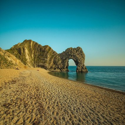
Durdle Door
A natural arch of Portland limestone was once part of a long line of stone but has now collapsed leaving several stumps off of Bat's Head to cow rock. The stumps from Durdle Door are the bull, the blind cow, the cow and the calf. At a closer look at Durdle Door there are several holes which were once trees.
Coastal geomorphology
-
Lulworth Cove is a World Heritage site and part of the Heritage Coastline
-
It is one of the best examples in Europe of the stages of erosion on a concordant coastline
-
The coast is very young due to recent ice ages and resulting sea level change. The processes have been operating over the last 8000 years
-
A Concordant Coastline
-
Bays more elongated and ovoid in shape
-
Headlands do not stick out as much
-
Rock strata parallel to sea
-
One rock type facing the sea, therefore rocks erode at the same rate.
-
A Discordant Coastline
-
Bays deep
-
Headlands stick out
-
Different rates of erosion, alternating hard and soft rock
Rock types
-
Portland Limestone - 150 million years (hardest)
-
Purbeck Limestone - 147 million years
-
Wealden Beds of sand and clay - 140 million years (softest)
-
Greensand (sandstone) - 125 million years
-
Chalk - 97 million years
Due to major movements of the earth's crust, streams have turned the rocks on their side and subsequent erosion, sea, weather and man have shaped the coast.
At each of the stages recommended the students to an annotated field sketch.
First stage - Stair Hole
-
An embryo cove - Represents sea's first breach of the Portland Limestone
-
Rocks behind Portland
-
Purbeck Limestone - Thinner bedding so more weaknesses for processes to attack
-
Wealden Clay - Susceptible to erosional processes other than the sea, roatoinal slumping and weathering
-
Processes utilise weaknesses in rocks - joints and bedding planes
-
Processes: hydraulic action, attrition, abrasion and corrosion
Second stage - Lulworth Cove
-
What happens as the processes happening at Stair Hole occur over a longer period of time
-
At the cove the sea and the river breached the Portland. After the last ice age a swollen river broke through the chalk and limestone. The sea has carved the core out
-
Portland limestone forms the barrier entrance to the cove as its more resistant. The sea hits here first and waves are detracted
-
Behind the limestone the sea has carved out the other rocks, as they are less resistant to erosion
-
Order of rocks for the sea inland - Portland, Purbeck, Wealden, Greensand and Chalk
-
Other features - dry valley, steam and cut through the chalk
-
Evidence of erosion:
-
Wealden: slumping of the clay and the sand as beach material
-
Chalk: pebbles on the beach and clue as to when cliffs last fell with level of vegetation on the cliffs
-
Purbeck: can see the blocks that have broken off on the beach
-
Third stage - St. Oswalds Bay
-
This is what occurs when two coves join up. Still evidence of two coves
-
Limestone blocks in water. Evidence that this is the most resistant as it is left
-
Sea is trying to straighten the coast again
-
Clay is a thinner band here, squashed by earth movements
Fourth stage - Durdle Door
-
Here you can see how the bay has been straightened - example of dynamic equilibrium
-
Sea attacked rock - once all limestone will go to being all chalk
-
See erosion of the chalk with arches and stacks
-
Caves due to faulting
-
Dry valleys
-
Durdle Door
-
Shingle Beach. Sorting and storm beaches and berms. Wave energy dissipated on shingle beaches
-
Limestone blocks in the water - trace to Isle of Portland
Site overview
Lulworth Cove, Stair Hole and Durdle Door: Coastal processes and Tourism
Coastal processes: Key points
-
What features can be found at these locations and what reasons have been suggested for their formation?
-
In what succession have these processes happened?
-
How do coastal processes affect these structures?
Project/hypothesis ideas
-
What will be the next evolutionary step at each of these key sites
-
Too many visitors to a honeypot site can do as much damage as natural erosion
-
How do you think global warming might affect this coast in the future
-
The sea is not the only factor responsible for the landforms of the Dorset coast
Tips/pitfalls
-
If possible visit the site during stormy weather conditions to see the power of the sea
-
Take spare camera batteries and film
Data collection
-
Photographs
-
Field sketches
-
Environmental quality survey
-
Use maps
-
Beach profiles/beach processes data
Review - Statistical
-
Analysis of beach processes data
-
Review - Presentation
-
Profiles
-
Bi-polar surveys
Tourism: Key points
-
Has tourism been of benefit to Lulworth Cove as a settlement?
-
How is tourism managed in Lulworth Cove?
-
Lulworth Cove and Durdle Door are tourist honey pot sites that require sensitive forms of management. What are these?
-
How can physical environments be managed to preserve their characteristics yet meet people's need for recreation?
Project/hypothesis ideas
-
What are the impacts of management schemes?
-
How much should be charged for parking and how should it be used?
-
How far have visitors travelled and how long is their stay?
Tips/pitfalls
-
If possible visit the site during different times of the day or year to see the difference in visitor numbers
Data Collection
-
Questionnaires
-
Photographs
-
Use maps
Review - Presentation
-
Isopleth maps
-
Bi-polar
File nameFiles
File type
Size
Download