New land-management policies and practices following advances in wilderness mapping
Research on spatial modelling of wilderness quality led to the development of a new wilderness quality index set out in the EU 2020 Biodiversity Strategy. This has directly informed protection policy and practice around the world, leading to the development of an international register of protected wilderness areas across Europe. Wilderness management plans have been implemented by five US National Parks, and national plans have been produced in China and France.
Issue
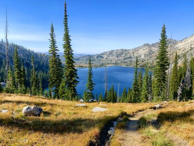
Wilderness is a precious resource that supports much of the world’s biodiversity and can act as a buffer against climate change. However, wilderness areas are being lost at an alarming rate and there is a critical need to recognise their value given the climate and biodiversity crises. Without rigorously defined geographical limits, wilderness areas are difficult to define and therefore protect.
Approach
Work led by the research team at Leeds has developed novel spatial modelling methods to define robust and defensible wilderness boundaries and provide effective long-term protection for the benefit of both humans and nature.
Researchers worked with Areas of Outstanding Natural Beauty (AONB) and the Scottish National Parks to improve methods for modelling concepts such as wilderness quality.
Techniques were advanced to classify wilderness quality and to validate result using participatory GIS that capture both public and expert opinion.
Impact
Adaptations of methods developed initially in Scotland have been used to map wilderness character and cumulative visual impact, and influence policy change amongst governments, government agencies and NGOs around the world.
Five US national parks, covering an area in excess of 40,000km2, have been mapped using the techniques, providing key information for protection of wilderness character and guiding park management plans.
The research was used to underpin the Chinese Ministry of Natural Resources’ expansion of China’s national parks and plans for a wilderness preservation system.
The research has led the way across Europe, forming the basis for a European-wide wild land definition and mapping programme. The EU now recognises wilderness areas as vital for achieving EU Habitats and Birds Directive’s objectives, and those of the wider EU 2020 Biodiversity Strategy and the new European Green Deal.
More information
Institution: University of Leeds
Researchers: Dr Steve Carver, Professor Alexis Comber
Share this resource
This is an open access article under the terms of the Creative Commons Attribution License (CC BY NC 4.0), which permits use, adaptation, distribution and reproduction in any medium or format, provided the original work is cited and it is for non-commercial purposes. Please contact us for other uses.
How to cite
Royal Geographical Society (with IBG) (2023) New land-management policies and practices following advances in wilderness mapping. Available at https://rgs.org/newlandmanagementpolicies Last accessed on: <date>