
Impact of geography
Explore the impact of geography through our case studies and resources.
Find an impact case study
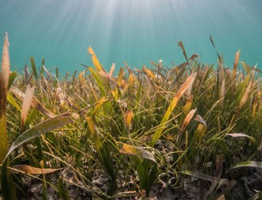
Using GIS to restore seagrass meadows
The Ocean Conservation Trust is replanting and restoring seagrass across the UK’s coasts, using a targeted, data driven, approach.

Transforming emergency and urgent care site selection with location intelligence
The NHS in the South, Central and West region partnered with Devon Integrated Care Board (ICB) to assess and redesign community urgent care in Devon.

Using 3D mapping to support emergency planning
Ordnance Survey’s (OS) 3D mapping has helped support disaster preparedness and emergency response efforts across the country.

Using geospatial data to coordinate disaster response in Myanmar and Mozambique
MapAction used geospatial mapping to support disaster response during the Myanmar earthquake and Mozambique floods, helping responders understand needs, locations, and priorities.

Using digital twins to manage damage to critical infrastructure
Helyx developed digital twins of road and power networks identifying damaged or destroyed infrastructure after disasters, supporting disaster response operations.
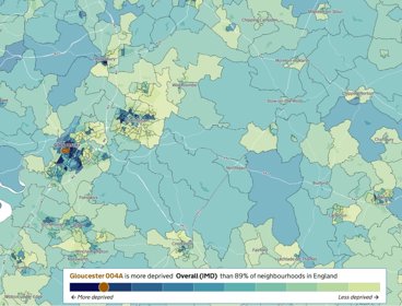
English Indices of Deprivation 2025
In 2025, the Ministry of Housing, Communities and Local Government (MHCLG) released the 2025 Indices of Deprivation (IoD) for England. This is the latest release in a series which started in 2000, created to allow decision makers to understand deprivation across England and updates the 2019 IoD.

Using satellite imagery to identify the largest methane plumes
The Stop Methane Project at University of California, Los Angeles (UCLA) analysed global methane emissions from oil and gas infrastructure, identifying the world’s 25 largest methane plumes detected in 2025.
Living England Habitat Map
Natural England’s Living England project is transforming monitoring habitat distribution and environmental change across England.

Integrating sea level rise projections into planning policy in Kaua’i County
Kaua‘i County, Hawaii has introduced a Sea Level Rise Constraint District which aims to ensure building developments are resilient to long term sea level rise impacts.
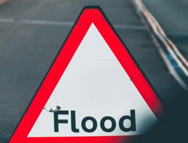
Identifying homes in flood risk areas across England
Aviva’s analysis reveals that the share of new homes built in England’s flood‑risk areas has increased significantly, with one in nine new properties constructed between 2022 and 2024 located in medium or high flood‑risk zones.

Mapping children’s access to playgrounds across England
Access to playgrounds and play areas are important to children’s health, well-being, and social development. The University of Sheffield have been investigating how access is dictated by geography and deprivation, and the inequality of provision.

Meeting the Bank of England’s climate standards
Ordnance Survey (OS) is helping financial institutions identify, measure, and manage climate risks across insurance and retail banking portfolios, to comply with the Bank of England’s new climate standards