UK Flood risk management: policy recommendations
Downloads
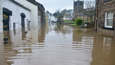
Managing flood risk in the UK is a major challenge, and is likely to become more severe as climate change continues. The Society convened a roundtable meeting of experts in May 2016 to discuss the challenges presented to the UK by flooding, and the contribution that geographical evidence and knowledge can make to tackling the issue.
These policy recommendations are derived from the roundtable discussions and subsequent work. Across 14 topics, we argue for review and adaptation of flood policy based on new modelling and historical evidence; better communication of flood risks and access to data; catchment-specific, catchment-scale responses such as natural flood management (NFM); and more collaboration and cooperation between different organisations in research, planning and building resilience.
Share this case study
This is an open access article under the terms of the Creative Commons Attribution License (CC BY NC 4.0), which permits use, adaptation, distribution and reproduction in any medium or format, provided the original work is cited and it is for non-commercial purposes. Please contact us for other uses.
How to cite
Royal Geographical Society (with IBG) (2016).UK Flood risk management: policy recommendations. Available at: https://rgs-rebuild.netcprev.co.uk/UKfloodriskmanagement Last accessed on: <date>