Relief models
The art of earth-building: placing relief models in the culture of modern geography.
Research by George Tobin.
Start: September 2017. Completion: 2024. University of Glasgow: PI Dr Hayden Lorimer and Dr Simon Naylor.
Overview
The project centers on the history of physical relief models in British geography, as crucial components of research and pedagogy. Models have been used variously throughout geography’s history to depict landscapes in 3-dimensions for use as teaching aids, visual illustrations, research instruments or as objects of display in museums and exhibitions.
They might take the form of mass-produced plastic models from mapmakers, specially commissioned works crafted over several months by sculptors, or simple plasticene structures made in school geography classes and discarded at the end of each lesson.
Each iteration of the relief model presents similar themes, debates and questions for geographers. How do we communicate geographical concepts in three dimensions? What do models do that maps, diagrams, photographs or fieldwork can’t? And in what ways is the practice of ‘doing geography’ creative and artistic?
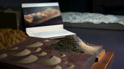
Central to this research is a collection of raised plaster relief models in the Society's collections. The models were produced by the sculptor Thomas Bayley for the 1951 publication The Earth’s Crust, a popular geography and geology book written by Sir Laurence Dudley Stamp. Stamp, a former president of the Society and prominent figure in 20th century British geography, had an aptitude for inspiring public interest in geography.
His work on land-use in the Land Utilisation Survey, and his multiple publications for the Collins’ New Naturalist series, cemented his status as a great populariser of geography of international renown. The Earth’s Crust and its models represent a key component of Stamp’s life-work and his agenda for widening public interest and knowledge in geography and geology.
Using models and materials from the Society's collections and further afield, the project will seek to establish a history of relief models in British geography, and place modelling amid wider geographic and scientific practices.
Find out more
You can watch a recording of a talk given by George about his research.
Key texts
- Bayley, T. (1938), The Craft of Model Making, Leicester: Dryad Press.
- de Chadarevian, S. & Hopwood, N. (Eds.) (2004), Models: The Third Dimension of Science, Stanford, CA: Stanford University Press.
- Debenham, F. (1937), Exercises in Cartography, London: Blackie & Son Ltd.
- Eves, J. (1961), Model Making in Schools, London: B. T. Batsford Ltd.
- McCalmont, M. (2015), A Wilderness of Rocks: The Impact of Relief Models on Data Science, Victoria, Canada: FriesenPress.
- Stamp, D. (1951), The Earth’s Crust: A New Approach to Physical Geography and Geology, London: Harrap.
- Walford, R. (2001), Geography in British Schools 1850-2000, London: Woburn Press.
- White, A. T. (1958), Modelling Relief Maps, Leicester: Dryad Press.
- Whitehouse, W. E. (1915), Descriptive Handbook to the Relief Model of Wales, Cardiff: National Museum Wales.
Key sources
-
24 plaster relief models made by Thomas Bayley: the models produced for the 1951 Dudley Stamp book The Earth’s Crust are held in our Collections, and form a central component of this project.
-
Wiley Digital Archive: the WDA contains numerous references to relief models from the Society’s history. A notable example is the Everest model, where there are materials which tell the story of damage it sustained during transport, and the subsequent plans to have it repaired.
-
The Geographical Teacher/Geography Journal: the Geographical Association’s journal The Geographical Teacher (renamed Geography from 1927) contains numerous articles relating to the use of models in school classrooms. It provides an excellent resource for understanding the ways in which models were used for developing Geography education in the 20th century.
-
National Museum of Wales: National Relief Model of Wales: relief model produced with direction of renowned geographer HJ Fleure, in collaboration with Welsh universities and schools, for the opening of the National Museum of Wales in 1922, where it was on display until the 1980s.