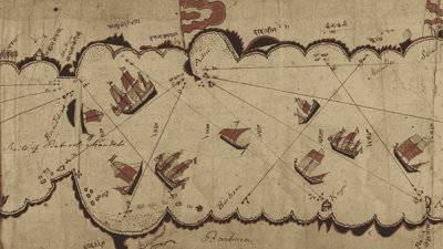
When feted British imperialist Alexander Burnes deposited a Gujarati chart of the Red Sea and Gulf of Aden with the Society soon after acquiring it in 1835, he declared it “specimen of naval surveying […] unequalled in any of the cabinets of Europe”. Yet he also described his trophy as “without any reference to longitude and latitude” and “rude” – a denigration that stuck.
A new study of the chart by the speakers, John P Cooper and Kumail Rajani, debunks this take on the chart, interpreting it instead as a rich documentation of both geographical knowledge and effective navigational technique among Gujarati navigators in the early 19th century.
- Webinar

The importance of aligning transport and spatial planning - DfT approaches and priorities
Join us for an insightful session with Robert Singleton and colleagues from the Department for Transport as they describe the work they have been undertaking to better align the spatial and transport planning systems.
OnlineProfessionalsThursday 7 May 2026 - Webinar

Geographic perspectives on disaster risk management: asset, infrastructure and exposure data
Join us for the first of a four-part webinar series covering the launch of a new book 'Geographical Perspectives on Disaster Risk Management' featuring members of the RGS Disaster Risk Management Professional Practice Group.
OnlineProfessionalsThursday 7 May 2026 - Lecture

Are PFAS a forever problem? How hydrology can help
In this lecture, Professor Patrick Byrne explains why PFAS pose such a long-term challenge and how modern hydrology can help tackle it.
Liverpool and onlineOpen to allThursday 7 May 2026