Looking for fieldwork ideas for Key Stage Three?
During this session, run in partnership with Ordnance Survey, we will explore options for mapping your fieldwork both locally and on your fieldtrips and introduce some apps that are available to help you.
The session is ideal for new users to get an idea of how Digimap for Schools can be used to support fieldwork, or current users who are looking to push their usage of Digimap for Schools and see where it can take them with their teaching.
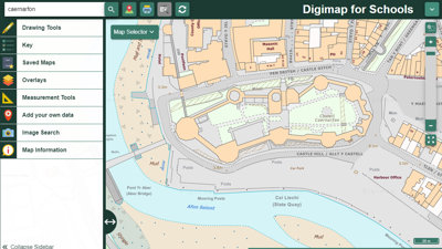
Digimap for Schools is an award winning online mapping service for use by teachers and pupils. With an intuitive interface, easy to understand tools and instructions, and no download or new software installation required, a teacher or a pupil can easily understand and start to use the service as soon as they log on.
Digimap for Schools supports cross-curricula teaching of geography, maths, literacy, and history and also enables teachers and pupils to gain critical digital and data skills.
You can sign up to Digimap for Schools on their website.
This event is being run in conjunction with Ordnance Survey.
Booking information
- Advance booking for this event is required. In order to book you will need an account on our website. If you already have an account you will be prompted to log in when you click 'book now'. Please create an account if you do not have one yet (you do not need to be a member of the Society to create an account).
- This event will be held on Microsoft Teams and joining instructions will be included in your confirmation email.
- Delegates will be sent details of how to access the event approximately a week before the event. If this email does not reach you, please contact us at events@rgs.org before the day of the event.
If you have any questions or require assistance with your booking, please email events@rgs.org
- Webinar

Embedding strategies for EAL students in geography
In this one-hour session, Fiona Sheriff will look at a range of practical strategies that can be used in the classroom to help multi-lingual students excel in geography.
OnlineTeachersWednesday 15 April 2026 - Webinar

Choose geography: careers in the built environment
A student webinar showcasing geographical careers in the built environment in collaboration with the Built Environment Schools Trust.
OnlineTeachersWednesday 22 April 2026 - Workshop - Beginner
Getting started with ArcGIS - April 2026
This CPD event is for teachers with little or no previous GIS experience.
LondonTeachersThursday 23 April 2026