
Join us for an insightful webinar exploring the Valuation Office Agency’s (VOA) first enterprise-level Geographic Information System: Valuation Mapping System (VMS). This is a joint webinar with the Royal Institution of Chartered Surveyors (RICS) and the Government Geography Profession (GGP).
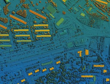
In 2019, the Business Systems Transformation (BST) programme was set up to address VOA’s aspiration to develop resilience to changes in government policy. This provided an opportunity to completely redesign the geospatial ecosystem, which is a core component of location intelligence used in property valuation.
In 2023, BST successfully delivered VOA’s first enterprise-level Geographical Information System, Valuation Mapping System (VMS), with the following activities:
- Incorporating business and users’ needs closely during the design of application, change management, and learning; and incorporating best practices from other organisations.
- Reducing development time, cutting expenses, and enabling reconfiguration for any type of mapping by using a single source code to create various VMS versions.
- Enabling the historical mapping, multi-criteria decision-making, and interactive exploration through linked views.
- Using rigorous novel geo-analytics to redefine how VOA models and visualises the geographical homogeneity of valuation and link the properties to other geospatial intelligence.
Booking information
- Advance booking for this event is required. In order to book you will need an account on our website. If you already have an account you will be prompted to log in when you click 'book now'. Please create an account if you do not have one yet (you do not need to be a member of the Society to create an account).
- This event will be held on Zoom and joining instructions will be included in your confirmation email.
If you have any questions or require assistance with your booking, please email events@rgs.org
- Webinar

Geography in practice: WorldPop - how geospatial data puts people on the map
This webinar will explore how the WorldPop Research Group at the University of Southampton is combining traditional survey data with new geospatial data sources to develop innovative data science methods that can help us to better understand the spatial distribution of people across the globe.
OnlineOpen to allWednesday 3 September 2025 - Webinar

Geography in practice: fixing the foundations - a call for GIS standards in BNG
This webinar explores the FRIDAS® checklist, a practical framework for improving Geographic Information System (GIS) data quality in Biodiversity Net Gain (BNG) submissions.
OnlineOpen to allTuesday 9 September 2025 - Workshop
Empowering Level 4 students with geospatial skills - CPD
In this hands-on workshop we will look at ways that you can give your first-year students a gentle on-ramp to GIS which gives them the confidence to use GIS to solve geographical problems.
LondonOpen to allMonday 15 September 2025