Geospatial Intelligence for Crisis Response symposium
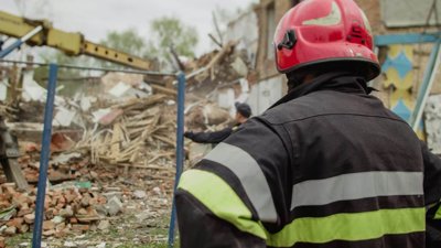
On 18 February 2026, we hosted a symposium titled ‘Geospatial Intelligence for Crisis Response’, with the Disaster Risk Management Professional Practice Group (DRM PPG).
Bringing together practitioners and researchers from across the fields of geography, emergency response, disaster management, and search and rescue (SAR) operations, the event explored how geography, spatial analysis, search theory and geospatial technologies are reshaping crisis response in the UK and internationally.
Opening the symposium, Chris Ewing (Chair of DRM PPG), welcomed delegates and reflected on a winter that has already tested UK resilience, with January 2026 being the wettest on record in many areas across the country.
Against a backdrop of increasingly frequent and severe global disasters, he emphasised the need to continually strengthen operational response including Search and Rescue (SAR) while embedding lessons into preparedness and planning.
The keynote address was delivered by Dr Robert Koester (Virginia Department of Emergency Management), whose work on lost person behaviour has become foundational to modern SAR.
Drawing on the International Search and Rescue Incident Database (ISRID), he demonstrated how probabilistic thinking, stochastic approaches and agent-based modelling are improving our understanding of where and when missing persons are likely to be found.
His distinction between 'missing' and 'lost' persons, alongside insights into behavioural patterns across different climatic domains, underscored the importance of evidence-led search planning.
Session one: foundations of modern search operations
The first half of the event examined the conceptual and operational foundations of modern search.
- Dr Alun Newsome (Re:Searchers Ltd) introduced a Domain-Terrain-Environment (DTE) taxonomy. By classifying the operational search area (domain), the physical search surface (terrain) and contextual modifiers (environment), he proposed a structure for configuring SAR resources more effectively and enabling cross-domain collaboration.
- Dr Geoff Newiss (University of Portsmouth) presented findings on men reported missing after a night out. Drawing on national data and case analysis, he highlighted the heightened risk of fatality over time of exposure, strong seasonal patterns around Christmas/New Year, and the prevalence of water as a recovery location. This illustrated how geographic analysis can inform faster, more targeted responses.
- Dr Craig Colley (University of Portsmouth) focused on water-related search operations, emphasising the variability of water environments, jurisdictional complexity, and the moral and legal ambiguities facing volunteer and institutional responders.
- Dr Ian Greatbatch (University of Portsmouth / Aston University) focused on six spatial dimensions of SAR, defining the term 'search to rescue' and spanning spatial, biological, cultural, moral, political and analytical perspectives.
Session two: practical applications
The second session turned to applied geospatial intelligence.
- Heather Papworth (Helyx Secure Information Systems) demonstrated how Earth Observation Digital Twins can integrate satellite imagery, street-level data and open mapping to assess infrastructure damage, using examples such as the Baltimore Bridge collapse.
- Harry Machette-Downes (MapAction) shared field insights from Mozambique and Myanmar, illustrating how rapid mapping supports decision-making during floods and post-disaster building assessments, as well as the risks associated with machine learning and AI in mapping.
- Pete Masters (Humanitarian OpenStreetMap Team) explored innovations in remote mapping, drone imagery and AI-supported tools such as ChatMap, while acknowledging persistent challenges such as connectivity and feedback loops.
In closing remarks, Dr Paul Smith (Institute for Civil Protection and Emergency
Management) challenged the audience to consider how complexity and randomness in crisis events can be made more manageable through clearer risk definitions and a commonly recognised information picture (CRIP).
Across the afternoon, one theme was constant: geography is central to crisis response. From open mapping to digital twins, geospatial intelligence acts as a central tool in emergency operations.
By bringing together research, professional practice and volunteer expertise, the insights shared at the symposium can help strengthen preparedness, improve response efforts and, ultimately, save lives.
The symposium was held in memory of Toby Meredith, a valued member of the SAR practitioner and researcher community, who tragically passed away in 2025.