Matthew Blackett
Lecturer in Natural Hazards, Coventry University
Geographers have a detailed spatial awareness and the set of skills that come with this offer a unique perspective into disasters
I fell into DRM largely by chance. I completed my PhD using satellite imagery to monitor volcanic activity and that led me to being a lecturer in natural hazards. Coventry University is renowned for its disaster management work and when I arrived there, I was fortunate enough to work closely with disaster management academics and practitioners, using my experience in remote sensing and GIS to contribute to the field.
What is the importance of location in the context of DRM?
Everything has a spatial location, including where disasters occur. This means that disasters have a true geographical dimension. We need to know where a disaster happened, who was affected and its extent
How do the spatial aspects interact with the other elements of DRM?
The impacts of a disaster will vary spatially, so it’s important to understand spatial variations.
How do you apply geography in your work?
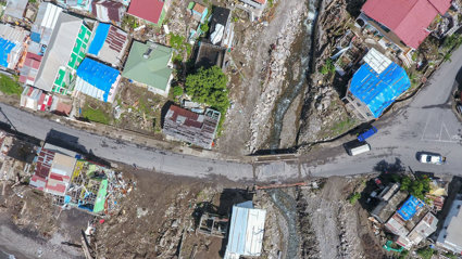
I work using GIS and remote sensing to allow for a spatial perspective on disasters: to understand the areas affected, the areas vulnerable, the areas which need relief, the areas which are cut off.
How would you encourage geographers to work with DRM?
Geographers have intrinsically developed a detailed spatial awareness and the set of skills that come with this offer a unique perspective into disasters – and one which is very useful in their management