
Bringing enquiry into the geography classroom through questioning, Bloom’s Taxonomy and AI
Enquiry is at the core of geography, everything we do as geographers can be traced to back to enquiry. This process enables pupils to explore often complex interactions between people, place and environment while engaging with different perspectives.
One of the most effective ways to promote enquiry in the classroom is through purposeful questioning whether that is through hinge, probing or open questions. Using artificial intelligence (AI) tools, questioning can be more inclusive for Lower Prior Attaining (LPA) pupils and intellectually challenging, supporting deeper geographical understanding for Higher Prior Attaining (HPA) pupils.
Bloom’s Taxonomy provides a hierarchical framework for cognitive thinking, progressing from lower-order skills such as remembering and understanding to high-order skills including analysing, evaluating and creating. In an enquiry-based geography classroom, this structure allows teachers to scaffold learning effectively.
AI tools can significantly enhance this process. Generative AI platforms can support teachers by rapidly generating differentiated questions aligned to Blooms Taxonomy, reducing teacher workload while maintaining cognitive challenge.
For example, AI can produce multiple versions of an enquiry question tailored to varying level of prior knowledge, literacy or confidence. This allows all pupils to access enquiry, while still being challenged appropriately.
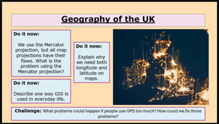
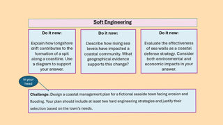
Below are two examples, the first one from a year seven class ‘do it now’ task and the second from a year 10 IGCSE class ‘do it now’ task. All four questions were generated in under 15 seconds using the prompts above each screenshot.
‘Using blooms taxonomy, create me three questions and a challenge question for a year seven class about the Mercator projection, longitude and latitude and the use of GIS.’
‘Using blooms taxonomy, generate me three questions and a challenge question for Edexcel IGCSE Geography Y10 class on longshore drift, sea level change, hard engineering/shoreline management plans.’
By combining Bloom’s Taxonomy, purposeful questioning and AI, geography teachers can create classrooms where enquiry is accessible. This approach allows pupils to think deeply, understand differing viewpoints and engage meaningfully with the complex challenges children are growing up in.
Tristram Randall FRGS, Teacher of Geography at RGS Surrey Hills.