Coastal surges and flooding in the UK: a prompt for more sustainable drainage?
January 2014
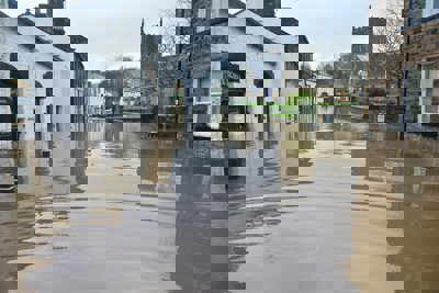
The heavy wind and rain arrived shortly after the New Year and by 5 January 2014 there were flood alerts in every region in England and Wales – as well as flood warnings in Northern Ireland and Scotland. Intense storms caused coastal surges and heavy rainfall which led to extensive flooding across the country, particularly in the south and south east.
What caused the storms?
In early January 2014 the UK experienced the worst band of storms in 20 years. It is unusual for so many storms to come after one another in such a short space of time. A series of depressions brought with them heavy bands of rain and extremely strong winds which swept across the country. The Met Office confirmed that Britain was feeling the effects of an unusually strong jet stream, part of the same system that was causing extraordinary effects in the US. See other Geography in the News article – The Deep Freeze: United States and the shifting Polar vortex.
 What were the effects of the storms?
Over the 2013 Christmas period the UK had already experienced heavy rainfall from previous storms which meant that much of the ground was already saturated and existing river levels were swollen. This made the risk of flooding in many areas higher and the onset of more rainfall even more problematic. Furthermore, the saturated land made tree falls more likely in the strong winds.
The Environment Agency issued flood warnings or alerts for every region of England and Wales, and many remained active for an extended period of time:
-
3 January: 115 flood warnings and 223 flood alerts
-
8 January: 108 flood warnings and 194 flood alerts
-
17 January: 35 flood warnings and 144 flood alerts
In 2012 the Environment Agency introduced a three tier warning system to indicate the level of threat from flooding:
-
flood alert to indicate that people should be prepared for flooding
-
flood warning which means immediate action is required
-
severe flood warning which indicates there is danger to life (12 of these were issued in the Devon and Cornwall area on 03 January 2014).
You can see the symbols and details about each of these warnings on the Environment Agency website. It is possible to search by postcode to see if any alerts are in place for any area of England and Wales. It was established as part of a strategy by the Environment Agency to make warning messages easier to understand.
In response to the 2014 floods the Environment Agency had teams working around the clock to maintain existing flood defences as well as clearing watercourses, deploying water pumps to drain areas, and establishing temporary defences to protect communities at severe risk.
Despite their efforts:
-
more than 550 homes were flooded
-
three people killed and over 570 properties flooded in England and Wales
-
train travel was disrupted across much of the country, particularly in the south and south east
In many coastal areas, particularly the south of England and Wales, the situation was extremely dangerous as strong waves crashed along the coastline:
-
people were warned not to go near the coastline unless absolutely necessary as the incoming waves were violent and posed significant threat to life
-
in many areas coastal defences such as sea walls were damaged
-
waves were over eight metres high in Land’s End, Cornwall
-
the arch formation at Porthcothan Bay, Cornwall was destroyed by eight metre tall waves and 110km/h wind
-
in areas of Dorset flood sirens were used to warn people as the sea had breached Chesil beach
A battered coastline: Aberystwyth
The coastline at Aberystwyth experienced the effects severe weather on 7 January with heavy wind and rain causing the waves to hit the coastline with extreme force. It was so severe that students living in the university accommodation were evacuated.
A student who was evacuated from Aberystwyth described the scene:
"The high tide has come in and is being blown over onto the road and the promenade. The promenade is wrecked and big bits of it have been ripped up. All the railings have gone and most of the beach is now on the road. Some of the pebbles that have been washed in by the tide are the size of rugby balls and there’s concern that these could go through people’s windows. Most of the properties are boarded up and are sandbagged. Once it’s all over it’s going to be a massive clear-up." (Source: Independent)
Much of the promenade in Aberystwyth experienced serious damage. However, some residents consider there to be positive effects of the storm damage as they feel it has raised the profile of the area with so much publicity in the media. They think more people have now heard of Aberystwyth and feel that in the long term it might boost tourism to the area.
The aftermath
The Environment Agency highlighted that the storms had tested 3,000km of flood defences in England and Wales and over 200,000 properties were protected from flooding. However, dealing with the effect of flooding is expensive and can place extreme financial burdens on both families and businesses, particularly for those not covered by insurance, as well as local and national government. NatWest and RBS set up a £250 million interest free loan fund to try and support businesses that were affected by the storms.
In other places councils have recognised the need to establish further flood prevention strategies. Somerset county council has recognised there is a need to improve their flood prevention strategies and is planning to spend £1m on dredging rivers and other flood-prevention schemes. It has even launched a social media campaign to try to get more help from central government as parts of south-west England remained underwater almost four weeks after the torrential rains began.
Flood Management
The damage caused by the storm surges and floods is a reminder of the need for effective flood management schemes. The Department for Environment, Food and Rural Affairs (DEFRA) has stressed the importance of reducing the impact of flooding and it has made it a key priority to ensure that more sustainable drainage systems are put in place to help reduce future risk. In 2010 The Flood and Water Management Act was passed which stated that developers should stop constructing buildings that make flooding worse.
Sustainable Drainage Systems (SuDS), sometimes called ‘Smart Drainage systems’ or ‘Green Drainage’ involve using techniques that manages surface water and groundwater sustainably, reducing reliance wholly on sewer systems. This is often done by installing ponds, or other features in order to reduce surface run off. It is extremely effective.
The benefits include:
-
reduced flood risk
-
minimised water pollution
-
maintenance or restoration natural
-
flow regimes
-
improved water resources
Source: Environment Agency
An area which has been prone to flooding in the past has made efforts to address the issue using sustainable drainage systems.
Smart Drainage systems: Sheffield
In 2007 areas of Sheffield were heavily flooded which prompted work to improve the protection of the area. In South East Sheffield sustainable drainage systems have been installed in newly built areas to capture rainwater and reduce the risk of flooding. In most new developments (and indeed most areas) rainfall will flow directly into sewers or rivers making the risk of flooding higher. The smart drainage system works by allowing rainfall and water than accumulates on the surface to be carried by pipes to a pile of rocks in a pond away from the buildings which then allows the water to infiltrate into the ground more slowly. This kind of system also benefits the biodiversity and landscape in the area as the ponds used to collect this water and can attract wildlife, including ducks, dragonflies and even herons.
While these systems have been welcomed by councils and residents, construction businesses are not as positive as they highlight that ponds take space and that makes properties more expensive (and they can fit fewer properties in an area of land). Some builders would prefer to trap excess water in tanks underground. However there are concerns from residents and councils over who would provide the maintenance for these tanks once the properties are solved.
The Flood and Water Management Act of 2010 means that builders have an obligation to landscape new developments so that water from roofs and driveways has a route to infiltrate into open ground rather than going directly into the sewer system. These measures often termed ‘green drainage’ should in theory reduce the risk of flooding, however many builders feel they need flexibility as it is not always possible to do this.
Professor Ashley from the University of Sheffield has highlighted that while ensuring new buildings are not significantly increasing flood risk is important – new buildings are actually only a small proportion of buildings in urban areas, and therefore it is often many of the existing buildings which still remain a significant problem.
References
Environment Agency: Flood warnings explained
‘Flooding risk remains as more heavy rain is forecast for the UK’ Guardian 07 January 2014
‘Moves to end flood prevention plans delay’ BBC News 10 January 2014
‘UK’s worst winter storms for two decades set to continue’ Guardian 05 January 2014
‘Somerset to spend £1m on flood prevention’ Guardian 16 January 2014
‘Storm battered Aberystwyth mops up and aims to bounce back’ Guardian 09 January 2014
‘Storms destroy Porthcothan bay Rock arch formation at Cornwall beach’ Independent 07 January 2014
‘Weatherwatch: A fast jet stream causes serial depression’ Guardian 05 January 2014
File nameFiles
File type
Size
Download