Glacial retreat: Historical evidence of climate change in Mongolia
June 2013
Based on research by Ulrich Kamp, Kevin G. McManigal, Avirmed Dashtseren and Michael Walther.
This research analyses glacial retreat in the Turgen Mountains, northwestern Mongolia. Located around 80 km south of the Russian border, the area was visited by a Royal Geographical Society expedition in 1910. This expedition involved surveying and photography of the glaciers in the area.
100 years later, an expedition returned to the Turgen Mountains in 2010. The expedition was led by the University of Montana and involved collaboration with the Mongolian Academy of Sciences and the National University of Mongolia. Retracing sections of the original expedition, the 2010 expedition sought to take photographs from the same locations and angles as those taken in 1910. These repeated photographs were used to help understand how the glacial system has changed over the last century.
The need to understand glacial retreat
The world is currently going through an inter-glacial period, whereby the earth’s atmosphere, oceans and land experience warming. The effects of this warming can be observed and measured – as glacial down-wasting, for example.
Glaciers provide an important source of water in cold environments. The fragile ecosystems of flora, fauna and humans often depend of these water stores (or ‘water towers’). It is therefore important to measure the health and extent of these glaciers.
Case study: Turgen Mountains, Mongolia
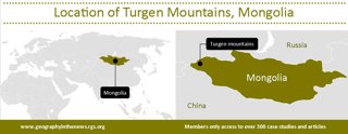
Figure 2: Maps to show location of Turgen Mountains, Mongolia.
The Turgen Mountains formed as a result of tectonic uplift and are heavily glaciated on their northern sides. Glacial erosion has created large U-shaped valleys bordered by cirques and hanging valleys. Their melt-water feeds several rivers in the region.
In 1910, Douglas Carruthers led the original expedition to the Turgen Mountains, which he described as ‘a snow-capped mountain of alpine character’. He added: ‘the Turgen stands solitary, rising sharply above the steppes and the desert-ranges which surround it on all sides.’
As a landlocked country, Mongolia experiences an extreme continental climate, characterised by low winter temperatures (averaging -25°C in January in the capital of Ulaanbaatar) and low humidity. Summers are dominated by westerly winds that bring precipitation across from the Atlantic Ocean and Mediterranean Sea. Winters are cold and dry, even causing some summer snow to be ablated, with snow being removed from the glaciers but not being replaced due to a lack of winter precipitation In fact, 70% of the annual precipitation falls during June, July and August. Much of this falls as snow at high altitudes.
However, the recently warming climate has caused glacial retreat and down-wasting. From the 1940s to the early 1990s, the mean annual air temperature in Mongolia increased by more than 1.5°C, which would result in increased rates of ablation. In fact, the glaciers have been retreating for some time. For example, in 1910 Douglas Carruthers noted recessional moraines around one mile from the snouts of some glaciers, all of which were in a state of retreat.
Watch this video to view 100 years of glacial change in the Turgen Mountains. This compilation of photographs illustrates how repeat photographs can show glacial down-wasting and retreat.
Improving on previous research
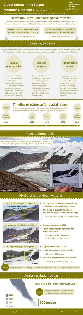
Global climatic shifts have had an effect on glaciers in Mongolia. However, a number of studies have drawn considerably different conclusions as to the exact impact of this warming. One study in 2007 found that the Turgen glaciers had lost 19% of their surface area since 1970. However, a study the year later found that the glacier’s surface area had decreased by a much larger 35% over a similar timescale.
This research attempts to improve on the existing academic research (published in 2007 and 2008) in three areas:
-
Methods: Existing research used Geographical Information Systems (GIS) only. However, there were great differences between their respective findings. This research will use a range of methods to overcome such inconsistencies.
-
Secondary data: Existing research relied solely on secondary data. In order to validate such data, this research undertook fieldwork and collected primary data (repeat photography).
-
Historical records: Existing studies of the Turgen mountains date back to the late 1940s. However, the archive resources from the 1910 expedition extended the timeline of this research by 40 years.
Data sources
The 2010 expedition to the Turgen Mountains collected photos from the same location and angles as those taken in 1910. This repeat photography focused on the West Turgen glacier allows comparisons of its thickness. Other historical expedition documents (maps and diaries) from 1910 also proved useful in extending modern records of glacial change.
In addition to the data collected from the two expeditions, topographic maps from 1970 and satellite imagery from 1992 and 2010 were also used to measure how the size and shape of the West Turgen glacier has changed over time.
Methods
-
Pixel analysis: A combination of repeat photography and 3D modeling was used to calculate the rate of glacial down-wasting over the last 100 years. Firstly, 3D computer modeling of the landscape in 2010 was used to calculate the distance between the top of the glacier and a rocky ridge above the glacier, which acted as a reference point. Then, photographs taken in 1910 and 2010 were used to calculate how much that distance had increased by –indicating how much the glacier had thinned, or down-wasted.
-
Satellite analysis: Satellite imagery and topographic maps were used to determine the size and location of the glacier at various intervals between 1910 and 2010. This indicated how much the glacier has retreated by. Prior to 1992, good satellite imagery was not available for the Turgen Mountains and so historical maps had to be used. Current maps were used to validate their accuracy.
Results
Volumes of ice on the summits of the Turgen Mountains appear to remain healthy. However, the glaciers in the region show evidence of significant retreat and down-wasting at lower heights. Between 1910 and 2010, the West Turgen glacier retreated by around 600m and down-wasted by around 70m.
Conclusions
Historical records (photos, maps and diaries) proved useful in extending the timeline of evidence for glacial retreat and down-wasting in the Turgen Mountains.
Primary data, a range of sources and a mix of methods allowed existing evidence to be verified. This improved the reliability of the research results.
This research supports the finding that the glaciers in the Turgen Mountains have been in a state of retreat for more than a century. This is due to a warming climate, which is set to continue. As such, the ongoing retreat of glaciers is predicted.
Glossary
Ablation: The removal of ice from a glacier, most commonly through meltwater. This can result in a glacier retreating and/or downwasting. Ablation is the opposite of accumulation.
Down-wasting: The thinning of a glacier due to ablation.
Geographical Information Systems (GIS): A type of computer software used to analyse geographic information. GIS allows spatial data to be layered upon one another and manipulated by the user.
Glacial budget: The rate of accumulation minus the rate of ablation. A negative glacial budget will result in down-wasting and retreat.
Inter-glacial period: The climatic period of warmer global temperatures. Unlike a glacial period, much earth’s surface is not covered in ice. Inter-glacial periods can last for around 100,000 years at a time.
Retreat: The decreasing length of a glacier. Often characterised by the glacier’s snout (or terminus) moving backwards. A result of a negative glacial budget.
Activity
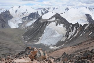
Figure 3: A photograph of the Turgen Mountains (©2010 McManigal)
-
Draw an annotated sketch of figure 3 to show the main features (e.g. moraine, arête, glacial snout…) and processes (e.g. weathering, abrasion, retreat, ablation…) of this cold environment (5)
-
Explain how photographs can be used to measure rates of glacial retreat and down-wasting (10)
-
Using the evidence presented in this research summary, critically evaluate the use of photographs, maps and satellite imagery as evidence of climate change (15)
-
Consider the environmental and ecological implications of a glacial retreat and down-wasting in the Turgen Mountains. In addition to this article, you should also carry out your own research. Use the World Glacier Monitoring Service’s online database for your research
File nameFiles
File type
Size
Download