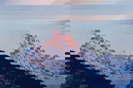
How glaciers shape the land and what they leave behind
This lesson focuses on how glaciers create spectacular and varied landscapes
Key questions
What is erosion, and how do glaciers erode?
How do glaciers move eroded material?
What is deposition, and how do glaciers deposit?
What is distinctive about a glaciated landscape?
Glaciated landscapes are among the world’s most scenic and spectacular; and although these often remote and rugged places can pose challenges for people, they also provide many benefits. For instance, glacial meltwater flowing down steep slopes can be harnessed for hydroelectric power, and glaciated areas present many opportunities for tourism such as climbing and skiing.
Beyond just using or appreciating a landscape, thinking like a geographer involves trying to ‘read a landscape’ for clues as to how it has formed, how it is changing, and how it may be different in the future.
A good start to reading any landscape is to think about the ‘weathering’ and ‘erosion’ processes that are affecting that landscape (or that have affected it at times in the past). Weathering refers to the weakening and breakdown of rock in its position (without being moved); whereas erosion refers to the picking up and removal of the weathered rock, thereby wearing away the land. Along with water and wind, glacier ice is a very powerful cause of erosion.
Places with glaciers have specific types of weathering, and glaciers erode in certain ways that lead to very distinctive landscapes. Glaciers also move a huge amount of rock debris from one place to another – where this is left behind it is called a glacial deposit (a ‘moraine’). Meltwater from glaciers also erodes and deposits. In this lesson you will learn more about these various processes, and you will learn to identify some of the key landscape features that result.
Starter
Glaciers create very distinctive landscapes; to get a feel for what is distinctive about them, download the Landscape image interpretation PowerPoint and look through the slides.
Each slide includes a question for you to consider about the images shown. Note down your own thoughts about each one, and these can be shared with the class during discussion.
Note that some of the images are of features that were caused by glaciation, but in places where glaciers no longer exist today. It’s very important at this point to be aware that in addition to ‘glacial environments’ (where glaciers are actively shaping the landscape today) there are also previously glaciated environments – places where the shape of the landscape today reflects the action of glaciers in the past.
Main Activity
As glaciers move, they erode, transport, and deposit. Although these processes happen relatively slowly (remember how slow glaciers typically move from Lesson two), over long periods of time, their effect on a landscape can be enormous.
Watch this Field Studies Council YouTube video (about five minutes long) for an overview of how glaciers shape the land.
While erosion, transport, and deposition are happening all the time along a glacier, it’s easiest to learn about each of these three different processes one at a time.
There are two main processes involved with erosion: ‘plucking’ (which involves pieces of rock beneath the glacier being ripped out by the moving ice) and ‘abrasion’ (which involves the rock debris being carried by the ice gouging and scouring the ground beneath and along the sides of the glacier.
Go to the Glaciers online photo glossary and look up the land features of glacial erosion listed below, and write down a brief definition or description for each.
Arête
Chattermarks
Cirque (Corrie)
Fjord
Striae
Glacial trough
Hanging valley
Horn
Roche moutonnée
Glaciers act like giant conveyor belts of weathered rocky debris, and as shown in this interactive debris is always being transported forwards with the glacier’s flow, even when a glacier is shrinking. Glaciers transport rock debris on their surface, inside them, and beneath them. The debris can move through the glacier in ice fractures called crevasses, and the debris sizes range from masses of fine grained clay up to large boulders.
Glaciers also transport other things besides rocks. Watch this Earth Unplugged YouTube video (about four minutes long) to find out more.
The rock debris builds up around the snout of a glacier (in its ablation zone), and this makes the lower parts of glaciers look ‘dirtier’ than the upper parts, especially in the summer. Eventually debris reaches the end of the glacier where it is deposited to form ‘end moraine’. The debris can also be deposited under and along the sides of glaciers.
When glaciers retreat back, or disappear completely, these mounds of deposited debris are left behind to create landscape shapes as unique and interesting as those caused by glacier erosion.
Go back to this Glaciers online photo glossary and look up the land features of glacial deposition listed below. Write down a brief definition or description for each.
Drumlin
Erratic
Lateral moraine
Moraine
Push moraine
Terminal moraine
Till
Now improve and expand your understanding of glacier erosion, transport, and deposition by downloading and completing the Glacier landscape definitions match and sort task.
Plenary
Now that you know more about the various processes and landforms related to glaciers, jot down as many ideas as you can about how ice shapes the land differently from running water (streams).
In areas that do not have glaciers today, what sorts of evidence would you look for in the landscape to prove that glaciers were there in the past? Share your ideas in class discussion.
There are no glaciers in the British Isles today, but the landscape across large areas has been shaped by glaciers in the past. The upland areas (e.g. the Scottish Highlands, the Lake District, and Snowdonia) show this most dramatically, although many lowland areas have also been affected. For instance much of the flat farmland in eastern England (e.g. East Anglia) looks the way it does because of huge, flat sheets of moraine that were deposited by ice sheets, filling in and smoothing out pre-existing hills and valleys.
You can now apply your understanding of how glaciers shape the land, and practice ‘reading a landscape’, by downloading and completing the Ordnance Survey map interpretation task.
File nameFiles
File type
Size
Download