The Met Office produced a forecast that predicted a BBQ summer that the Society reported on; how complex is it to make future forecasts like this?
It is quite complex to make seasonal forecasts. We do this very differently to the way in which the usual 5-day forecasts are made. When we want to go beyond 5 days we have to build different forecast models that join together what’s happening in the atmosphere with what’s happening in the oceans, as the oceans transport a lot of the energy that drives our weather on longer timescales.
We also make use of our knowledge of how weather across the world is related. For example if you look at the relationship between both the sea-surface temperature (SST) and pressure around Iceland and at the Azores in May, then this has been shown to be a good indicator of the likely winter weather conditions. This is called the North Atlantic Oscillation (or the NAO). You have probably heard of another of these oscillations, the more famous El Nino. El Nino is a large-scale warming of SST in the tropical Pacific which is so large that it can disrupt weather patterns around the globe.
So in making a seasonal forecast, meteorologists bring together the atmosphere-ocean model predictions and the statistical relationships into one combined forecast. Because of the nature of how the information is combined, the forecast is probabilistic and broader in detail. Therefore rather than saying it will rain, for example, on Saturday 15 August in Manchester at 4pm, the equivalent seasonal prediction would say it would be more likely to be warmer and wetter than the average for the north of England in August. This type of forecast is more useful for long term planning.
Just a quick word about the BBQ summer forecast. The Met Office’s forecast said that it would be more likely that we would have warmer than average temperatures and average or less than average rainfall for the period June, July, August. We have had warm temperatures, but it has been much wetter than expected. In fact in July we had twice the normal rainfall – certainly not good BBQ weather.
How does the accuracy of a monthly forecast compare to the 24 hour and 5 day forecasts?
As I mentioned above these are two very different types of forecasts and so it is not possible to compare the relative accuracy of these two forecasting methods. As the monthly forecasts are probabilistic the idea of accuracy means something different than the traditional deterministic 5-day forecast.
That sounds complicated but what I mean by that is that ‘accuracy’ takes on a different meaning in the two different types of forecast. For example if you take a forecast that says it will rain tomorrow at 4pm (a deterministic forecast) and it doesn’t rain then we can say that forecast is inaccurate. But a probability forecast might say there is a 65% chance it will rain and a 35% chance it will not rain. If is doesn’t rain, does that make the forecast inaccurate? We can certainly say it lacked forecast skill but you can see that the measure of accuracy is different between the deterministic and the probabilistic forecasts.
That doesn’t mean we do not measure separately the accuracy of the different types of forecasts – this is done regularly and the information is used to help drive new developments in all of the different forecast models used by meteorologists.
How has the accuracy of forecasting improved over the last 30 years?
The simple answer is quite a lot. Below is a picture from the Met Office website. It shows how the accuracy of their one, two, and three day forecasts have improved over the last 40 years, using a standard measure defined by the World Meteorological Organisation. As a rule of thumb we tend to improve our daily forecasting ability by a day in lead time every 10 years. If you think about it that is quite a remarkable feat, and we still have a way to go to reach the limit of predictability.
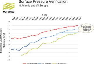
Surface Pressure Verification graph
Interestingly many of the developments that have enabled this accuracy to keep improving is down to the value of observations from meteorological satellites and the additional supercomputing power that has enabled us to use those observations and to increase the resolution of the forecast models.
What weather conditions does Britain have in a typical summer?
We define summer in meteorological terms as June, July and August and typical is what we would expect from the average as calculated over a 30 year period. This is an internationally defined standard and the timescale is chosen so as not to be too influenced by the variations in our year-to-year weather.
As a northern hemisphere country our summer is the warmer and dryer part of our year, in general. Although being in the mid-latitudes, each of our summer months have rain on about one-third of the days.
July is typically the warmest and driest of the summer months. Interestingly though, the month that is the driest and has the most sunshine hours in the whole year is May, so you can see that it’s no co-incidence that we have two May bank holidays.
You can find more useful information on the monthly and yearly climatology across the UK on the Met Office website.
What are the key meteorological processes that impact on our summer weather?
We are very lucky in the UK that we have varied and seasonal weather because of where we are located - an island in the mid-latitudes off a large continent with the Atlantic Ocean to the West. Much of our prevailing weather comes from the south-west in the form of mid-latitude depressions. In the summer months this generally changes and we have warm air that travels from the south.
What we often hope for in summer is an high pressure system that will sit over the UK and keep the warm, dry weather conditions with us for several days (and sometimes even weeks) at a time. We call this a ‘blocking’ high pressure, because it pushes away the incoming low pressure systems. It can have the down side thought that it also traps in pollutants and can cause poor air quality.
Over the last three summers the jet stream has been much further south than we would expect for the time of year. The jet stream is a fast flowing, narrow current of air that ribbons around the globe at high levels in the atmosphere (around 10km or so). The jet can help weather systems travel across the Atlantic and when the jet is far enough south it directs the prevailing weather towards the UK. This brings with it the unseasonably wet and windy weather conditions we have seen in recent summers and makes it more difficult for the high pressure systems to settle over the UK.
Given projections about climate change what might be the characteristics of our summer weather in the future?
Our climate is already changing; we know that because we can measure it. Already in the UK the average temperature has increased by approximately one degree centigrade since the 1970s and we know that the emissions of greenhouse gases are largely responsible for this. An amount of one degree centigrade doesn’t sound a lot but averaged over the year that is quite a large change. This is greater than the global average increase which is around 0.76oC.
The climate predictions for the UK estimate that temperatures will continue to warm, more so in the summer months than in winter, and this is likely to be the greatest in southern England, rising by a further three degrees centigrade by 2080. It is also predicted that summer rainfall will fall across most of the country, again by the largest amounts, a decrease of some 40%, in the south of England. With these types of conditions many of us will have much warmer, drier summers.
On the face of it, it sounds good that we might have more summers like the southern Mediterranean, but for the south of England in particular this could create significant shortages of water. The changes in rainfall and temperature will certainly mean that we will need to adapt to these conditions.
What the climate predictions are also telling us is that the extremes in our weather are changing. Climate models do differ in terms of their predictions for extremes, but in the broad sense what the models are telling us is that when the high temperatures come or the heavy rain falls in the summer months, the likelihood is that these events will be more severe and have greater impact on our communities.
You can find the latest information on the climate predications for the UK at the UK climate projections website.
Paul was interviewed in September 2009.
Biography of Professor Paul Hardaker, DMS, FRMetS, CMet, CEnv
Paul is a Mathematician by background whose early research work focused on modelling and instrument studies in radio propagation, working with organisations such as British Telecom, the European Space Agency and the Rutherford-Appleton Labs. He later moved to the Met Office where he spent 14 years in a variety of roles including heading up an international consultancy on hydrometeorology, and the Remote Sensing and Observations Branches. He then became Programme Director for the Met Office's Development Programmes and latterly the Met Office’s Chief Advisor to Government, providing support to the Government in areas such as climate change policy and the civil contingency programme.
Paul has led the UK delegation to several UN and EU technical committees on meteorology; he has been a member of the Physics Advisor Panel at the University of Wales, one of the Government’s Science and Society Champions, Chairman of one of the national e-Science projects, and the founding editor of the international journal Atmospheric Science Letters (ASL). Paul has also been the Interim General Manager for EcoConnect, a joint-venture between the UK and New Zealand Governments to provide environmental services across the globe, and for three years, a Non-Executive Director of a City company working in risk management.
Paul is currently Chief Executive of the Royal Meteorological Society (the Learned and Professional Society for weather and climate). He is also Chairman of the Research Council’s programme on the Flood Risk from Extreme Events (free) and holds visiting professorships at both the University of Salford and the University of Reading. Paul also provides external support to the Universities of Manchester and Leeds on aspects of their Weather and Climate academic courses. Paul is a Trustee and sits on the Board of the Science Council, he is a Director of the Society for the Environment, a Trustee of Sense about Science, a member of the Standards Quality Council for the qualifications awarding body PAA\VQSET, and is a regular contributor to BBC TV and Radio, and through his Blog, on weather and climate.
Outside of his work in meteorology, Paul spends one day a week working for the NHS as a Non-Executive Director and Deputy Chair of the Board of NHS Berkshire West, where he is actively involved with local and regional healthcare initiatives.