Mapping the River Thames
In this lesson students learn to name and locate the five longest rivers in the UK
Use the PowerPoint presentation in conjunction with the Lesson Plan. The PowerPoint presentation contains photographs, images and maps and follows the sequence of the lesson. The Factsheet, to accompany this lesson also explains some of the key points in more detail.
Key Objectives
To name and locate the five longest rivers in the UK.
To understand the key features of an OS map including:
-
Compass directions
-
The key
-
Four and six-figure grid references
-
Grid squares
-
Scale
-
Contour lines
To interpret an OS map to answer questions about a locality: The River Thames.
Additional Resources
String or thick cotton (optional; paper can also be used)
Web Links
To view the RGS-IBG Map Skills subject knowledge animation click here
Starter
Pupils take part in an ‘Around the World’ challenge.
The object of the game is for a pupil to correctly answer a question posed by the teacher before one of their classmates. By answering questions they get to travel ‘Around the World’, which in the context of the game means around the classroom. The questions should focus on the learning from the previous three lessons.
-
Pupil A stands behind Pupil B who is seated.
-
The teacher asks them a question. No one else is allowed to answer.
-
If Pupil A answers first, they can continue to travel ‘Around the World’, standing behind the next seated pupil, ready for another question.
-
If Pupil B answers first, they get the chance to travel ‘Around the World’ while Pupil A takes their vacated seat.
-
The winner is the pupil who answers the most questions, therefore travels the furthest.
Suggested questions include:
-
In which part of the river is the source found?
-
Does the water flow faster on the inside or outside of a meander?
-
Is the water deeper or more shallow on the inside or outside of a meander?
-
What is a confluence?
-
In 2007 which two rivers were responsible for the flooding of Tewkesbury?
-
What is a flood plain?
Remaining questions can be tailored to suit your own class.
Main Activity
Ask pupils whether they can name the longest rivers in the UK. Use an atlas to locate these.
-
River Severn, 354km
-
River Thames, 346km
-
River Trent, 297 km
-
River Great Ouse, 230km
-
River Wye, 215km
Then introduce the subject of maps: Ask pupils what types of map there are (street map, road map, tube map etc.). Clarify that maps are all 2D representations of a 3D or real world.
OS Maps: Today’s lesson will be looking specifically at OS maps (Ordnance Survey maps). These show topographical features and they are primarily maps of the landscape.
Initial impressions: Without contextualising the maps, hand pupils all three map extracts.
Ask pupils to look closely at the maps. What do they show? What similarities and differences are there? Ask for initial impressions and observations. Pupils may notice:
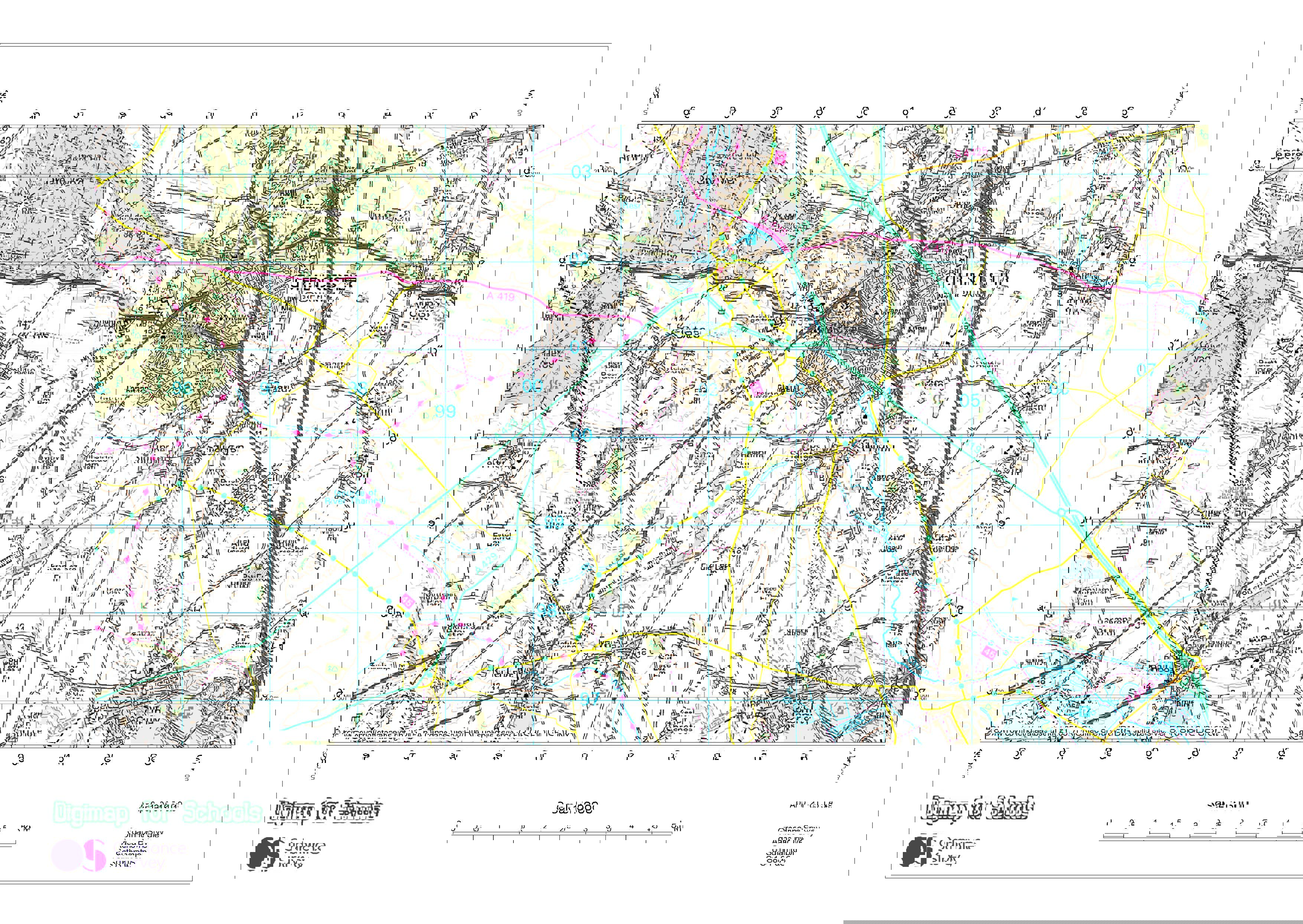
Map Extract 1
-
Has a town, Cirencester, and a wood (Oakley Wood) to the north.
-
Looks less built up in comparison to the other extracts (but may not know that this ‘emptiness’ is land and shows a comparatively rural landscape).
-
Has contour lines (but may not know what they are called or what the numbers represent).
-
Has farms
-
Has roads
-
Pupils may spot some ‘funny’ names: Three Mile Bottom, Jackaments Bottom, Butts Farm
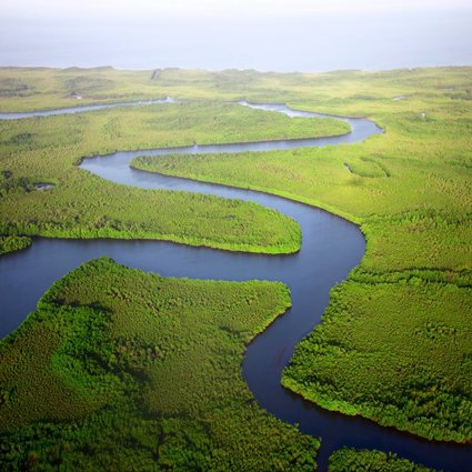
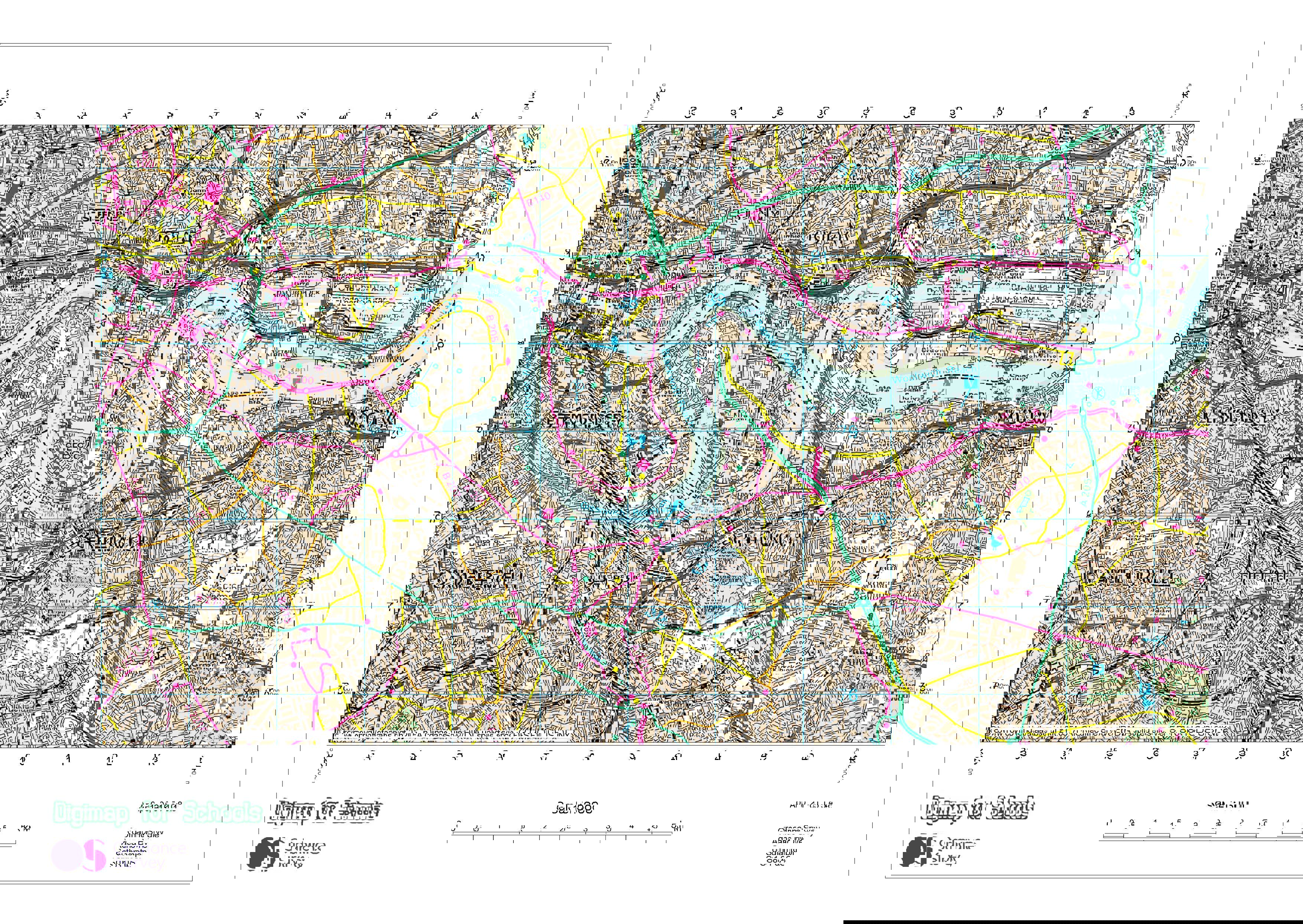
Map Extract 2
-
Shows London and the River Thames (they may recognise the familiar EastEnders meander).
-
Looks built up in comparison to the other extracts (but may not know what the map is depicting).
-
They may see the symbol for London Borough Boundaries through the River Thames and be confused by it.
-
There is a very small wood (Oxleas Wood) in the far south east corner (4476), but otherwise there is very little evidence of green space.
-
The river becomes progressively wider from west to east.
-
Map Extract 2 also has contour lines, but these are difficult to see and read.
Map Extract 3
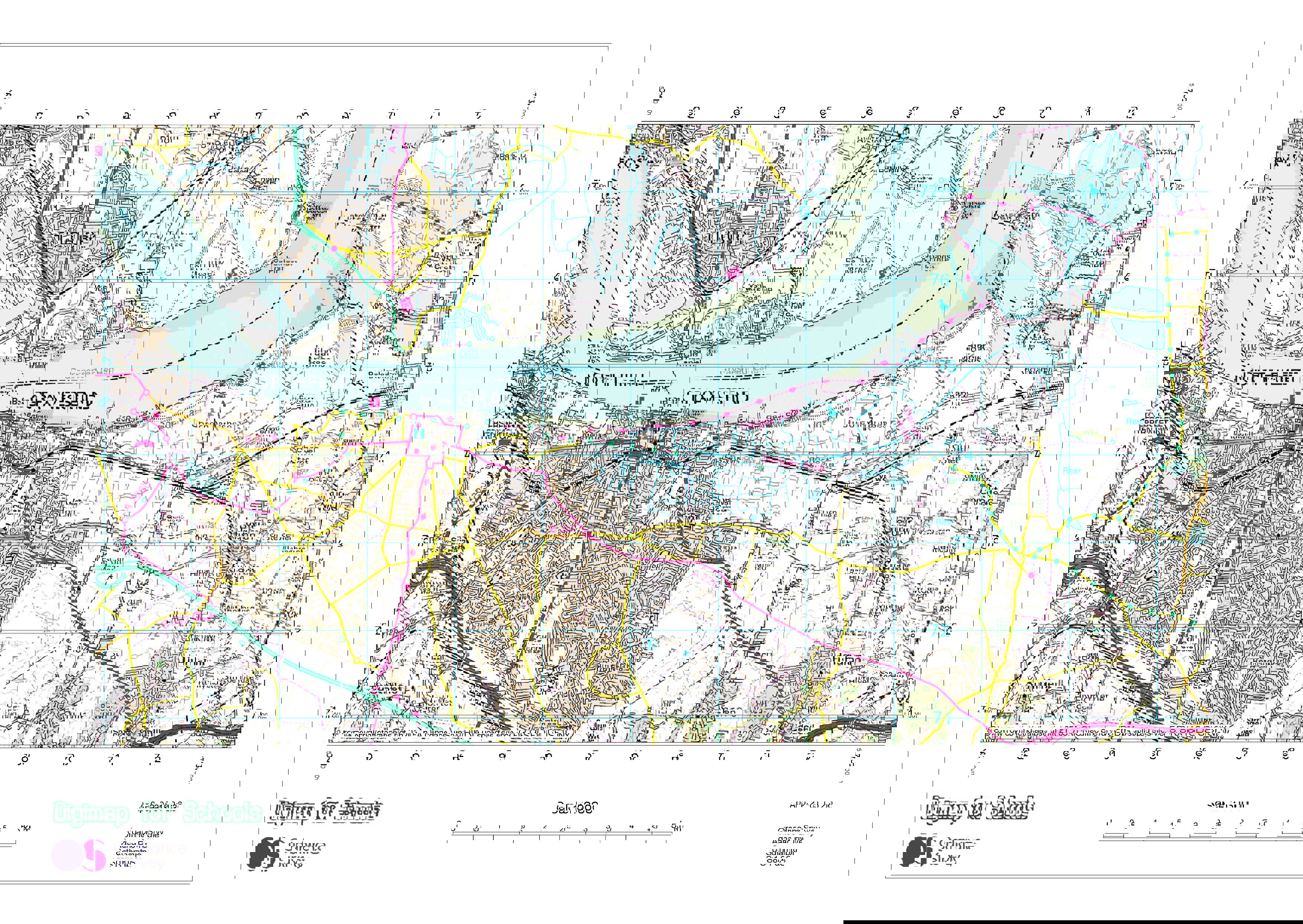
-
The river is very wide and again becomes progressively wider from west to east.
-
The river has a more sweeping meander.
-
In places the river ‘looks green’. (Mud banks are depicted, which is evidence that the lower course is tidal. The mud will be exposed at low tide).
-
There are expanses of water in the north east (Cliffe Pools). These are depicted with the symbol for nature reserve.
-
The map combines the rural/urban landscape of the other map extracts.
-
Has contour lines (but again may not know what they are called or what the numbers represent).
Any misconceptions can be discussed and clarified as the lesson progresses.
Then, explain to pupils that the OS Landranger maps show, in detail, the height of land, the type of vegetation, roads, footpaths and other features of the landscape- including water. This is a map that is used by walkers, horse riders, bird watchers - anyone experiencing the ‘great outdoors’.
Ordering the extracts: Explain that these map extracts are of one river- the Thames. Locate the River Thames on Google Earth. Ensure pupils know that it is located in southern England and flows into the North Sea.
Each map extract shows a different part of the river. Ask pupils to use prior learning and geographical evidence to order the map extracts. For example, they should be expected to know that a river is likely to meander in the middle course (Map Extract 2) and get wider as it flows into the lower course and estuary (Map Extract 3). They will also know that the source of many rivers is in rural/high land, and may be able to interpret the contour lines (Map Extract 1).
Establish the order of the extracts.
Then, focusing on Map Extract 1, or using OS Landranger 163, work through the maps skills detailed:
Using grid squares:
First find the village of Kemble in the south west corner of the map; the village is located in grid square 9897. Explain how to read grid squares and show pupils the image on the PowerPoint to help.
Next, find Thames Head, the source of the River Thames, located in grid square 9899 and establish that this is north of Kemble.
Four-figure and six- figure grid references:
Ask pupils to look in grid square 9898. Can they spot where the River Thames first becomes visible? (Look for the start of the blue line.) Then, ask pupils for the four-figure and six- figure grid reference for the visible source of the river (9898 and 986987). Follow the course of the River Thames. In what direction does it flow? (South east). Would this be uphill or downhill? What is the six figure grid reference for the point at which the river leaves the map? (013965. Be careful, there is a tributary west of the river at 011965 (shown by a thinner blue line) which may confuse pupils. The national trail/recreational route is adjacent to the River Thames and can help identify it for you).
Using the key:
From 013965 I want to return to the village of Kemble. Use the key to explain how I might do this (walk north west along the national trail/recreational route).
While in Kemble, I want to buy a refreshing drink. Look at the grid square 9897 and use the key. Is this possible? (Public house)
Ask pupils what other symbols/features they can see marked at Kemble. For example, a railway station, a railway with embankments and tunnels, a post office, a place of worship, a place of worship with a spire, minaret or dome, on road cycle route and road are also evident.
Allow pupils to familiarise themselves with the key and discover what these symbols mean. As the map shows primarily a rural location, ensure pupils use the key to establish the type of woodland in Oakley Wood and Hailey Wood, and throughout the locality (mixed wood).
Scale:
Explain to pupils how scale is depicted on a map- every 1cm on the map represents 0.5km on the ground. See the accompanying Factsheet to help.
As a class, calculate the length of the A433, Roman Road, from Jackaments Bottom 968977 following it north east to the turnoff for the A429 (returning to Kemble) at 001002. As the Roman Road is so straight, this can be easily done with a ruler. The length on the map is just over 8cm. Look on the scale and establish that this equates to 4km. Higher ability pupils may get a more exact measurement of 8.2cm or 4.1km. (On the A433 the symbol for The Thames Head public house, a famous local landmark, is also evident).
Next, using string or marked paper, establish the length of the River Thames, visible on Map Extract 1, from 986987 flowing to 013965. The river is narrow and winding, so this will be more difficult and the answers more approximate. Answers will be in the region of 9cm - 9.5cm or 4.5km – 4.75km.
Contour lines:
Contours are lines showing land of equal height. Contour lines that are close together show land that is steep, contour lines drawn further apart show land that is more gently sloped. The contours are drawn at 10m height intervals- although the metres unit of measure is not stated on the contour line.
Ask pupils to interpret the map. Which land is steeper- the land to the north and west of Kemble, or the land to the east of Kemble- why? (Land to the north and west is steeper- the contours are closer together).
At what height is South Leaze Farm 019976? (Follow the contour line north west to see the height of 100m).
Taking the on-road cycle route, would it be easier to cycle from Kemble (grid square 9897) to Tarlton (grid square 9699) or from Tarlton to Kemble? (From Tarlton to Kemble- the contours show that this is going downhill).
Using OS Landranger 163 and OS Landranger 177 or the map extracts provided, pupils should complete the Mapping the River Thames worksheet. This covers the main teaching points. An answer sheet is provided.
Pupils will also need a copy of the OS Landranger 1:50000 key, or the symbols contained in the Factsheet.
Plenary
Show pupils the photographs on the PowerPoint. Extend pupils’ understanding and interpretation of the maps by asking them to decide in which of the locations they would expect to see these places. Why? What is the evidence?
See the Factsheet for information about each location.
Homework Challenge
Can pupils can name and locate the five longest rivers in the UK? Give pupils a copy of an outline map of the UK and ensure they have access to an atlas. Using the atlas, can they draw on the position of each river onto the UK map? Pupils should also be expected to label key towns and cities, highest peaks and seas.
File nameFiles
File type
Size
Download