The River Thames
This lesson looks in detail at the River Thames- the physical characteristics of the river and its surrounding landscape
This lesson also examines how people’s interaction with the river changes. Pupils will also look closely at flooding, and the measures that have been put in place to prevent a major flooding event.
Use the PowerPoint presentation in conjunction with the Lesson Plan. The PowerPoint presentation contains photographs, maps and images and follows the sequence of the lesson. The Factsheet, to accompany this lesson also explains some of the key points in more detail.
Key Questions
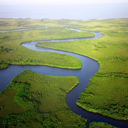
What are the physical characteristics of the River Thames?
How does the River Thames shape the surrounding landscape?
How does the River Thames change throughout its course?
How do people interact with the River Thames and surrounding landscape?
Why is the River Thames liable to flooding?
What is the role of the Thames Flood Barrier in preventing flooding?
How does the Thames Flood Barrier work?
Starter
Our Questions: In the last lesson, Mapping the River Thames, pupils were asked to devise two of their own enquiry questions about Map Extract 3, on the theme of direction and the use of the 8 points of the compass. Begin this lesson by asking the class a selection of these pupil-generated questions. Use the copy of Map Extract 3 on the accompanying PowerPoint, or allow pupils to refer to their own copy of the extract once more.
Main Activity
Ask pupils to recap what they know about the River Thames.
Clarify: The River Thames is the second longest river in the UK flowing 346km. Its source is at the Thames Head, just north of the village of Kemble and south west of Cirencester in Gloucester. Its mouth is the Thames Estuary, at Southend in Essex. It flows into the North Sea. Use Google Earth to show pupils the long profile of the River Thames and its location in the UK.
Ensure that pupils remember water flows downhill. From the last lesson can pupils remember the height (elevation) of the land at Thames Head? (Its source is 110m above sea level, its mouth is at 0 metres).
Look at the images on the PowerPoint, discuss with pupils what they might find at different points along the river.
The Source: The map detail shows clearly the source of the River Thames north of Kemble. The photographs show the public house close to the source and the railway station. Ask pupils to locate these on the map, using their knowledge of the Ordnance Survey symbols found on the key.
One photograph depicts the ‘source stone’. The stone reads, 'The Conservators of the River Thames 1857 – 1974. This stone was placed here to mark the source of the River Thames'.
Pupils may also be expecting to see high land, in the form of steep hills. They have already learnt that the source of many rivers is on high land. Ask pupils why they cannot see hills. Ensure pupils understand that the high land at the source (110m) falls away gradually over the course of the 346km of the river course. So, however ‘flat’ the land may appear at Kemble, it is still higher at the source in relation to the mouth.
Ask pupils why there is no water at the source. (The water is visible at the source after heavy rain. The source is not visible after a period of dry weather).
The next slide contrasts the source of the River Thames following dry and wet periods. This shows clearly how the location can flood after extreme precipitation- forming the upper course.
Ask pupils how people use the river at this point. (Walking along the Thames footpath and sightseeing will be the major uses.)
Cricklade- the navigable river: The River Thames first becomes navigable from Cricklade. The speed limit for boats at this point is 8km an hour, a brisk walking pace. At this point, only small boats, such as canoes can navigate the river. At Cricklade the land is approximately 87 metres above sea level (having dropped approximately 20 metres from the source at Thames head). Again, ask pupils how people would use the river at this point. Establish that the river is used for leisure pursuits (boating, fishing sightseeing), rather than commerical or industrial usage.
Teddington: Teddington marks the point where the non-tidal river becomes tidal.
The tide can raise the water level by up to 7 metres. Explain to pupils that a lock allows the water level in a small section of the river to be raised or lowered to allow boats up and down stream. Weirs allow the flow of water to be controlled. Teddington has three locks- of different sizes- and a weir. The largest lock is as wide as two double decker buses.
Teddington is 243km from Thames Head and 4.3m above sea level.
The river is becoming progressively wider at this point. The land is also flat.
Again, ask pupils to look at the photographs to see how the River Thames is used at this point. They will see that leisure pursuits, such as river cruises and boating are still a major part of the life of the river. The lock itself is also a focal point for tourists. One photograph also shows, in the background, a new development of apartments overlooking the river at Teddington. Teddington is on the outskirts of London. People commute into the city, as well as working locally. Housing is expensive here and a premium is paid for a river side view.
Use Google Earth to focus on the river at Teddington.
Central London: Show pupils the slide of Central London. At this point the River Thames is surrounded in urban development – both historical and modern.
The map locates some of the many landmarks, illustrating the vibrancy of the city. The photographs also show how the river is integral to the development of London.
The commercial character of London is evidenced by the City Airport and Canary Wharf. (Ask pupils why the location of an airport in the city is so important). The importance of tourism and leisure is evidenced by the O2 Arena and the Cable Car and the historical significance by Tower Bridge and the Cutty Sark.
The importance of the physical geography of the River Thames in shaping London is evidenced by the Thames Barrier. The map also shows the Royal Docks which, like Canary Wharf are undergoing extensive redevelopment.
At this point the river is in the middle course; the river is approximately 500m wide.
The Thames Barrier: The Thames Barrier, which came into operation in 1982, is the second largest flood barrier in the world. It spans 520 metres across the River Thames near Woolwich, and it protects 125 km2 of central London, 1.25 million people and £200 billion of property and infrastructure from flooding caused primarily by tidal surges.
Why the Thames Barrier was built: In 1953 a severe flood along the east coast and Thames Estuary resulted in 307 deaths and £50million worth of damage. Historically the solution to flooding was to build higher and stronger walls but these can be unsightly. It was decided that a barrier would be the best solution because it could be raised quickly and would not interfere with river traffic.
How the Barrier works: For an animated guide to how the Thames Barrier works click here.
How often has the barrier been closed? The Environment Agency has closed the Thames Barrier 174 times since 1982 (correct as of March 2014). Of these closures, 87 were to protect against tidal flooding and 87 to prevent river flooding. The number of closures has increased over recent decades.
Drainage Basin (also called the Catchment Area): While the primary purpose of the barrier is to protect London from flooding from the sea, the Thames Barrier may also be closed during periods of high water flow over Teddington Weir to reduce the risk of river flooding in west London. There are 38 main tributaries, and many more minor ones, that feed into the River Thames over an area of land over 13,000 km2.
As a class look to see what parts of Central London could be at risk of flooding. Buckingham Palace, for example, is only 10 metres above sea level. Could it flood? To find out, go to the Environment Agency website and use the postcode SW1A 1AA.
Pupils will complete a diagram of the long profile of the River Thames from its source at Thames Head to its mouth, where the estuary flows into the North Sea. Pupils should label the key locations the river passes through.
Then, using arrows and information boxes at different points, pupils can include extra diagrams and facts. For example:
-
The width of the river at different points and the relative elevation of the land (from Lesson three).
-
How the landscape changes.
-
Teddington Lock, where the river becomes tidal.
-
How people use the river and adjacent land at different points along its course.
-
The Thames Barrier. The role the Barrier plays in flood prevention and how the Barrier works.
Higher ability pupils could draw their long profile onto graph paper, devising a scale on the y axis for height of land. They could then show how the river flows from an elevation of 110m at its source to approximately 4 metres at Teddington Lock to 0 metres at the estuary.
Plenary
Peer assessment: Allow pupils to show their partners or the class their work. Scan in copies of pupils’ work if a scanner is available. Ask for peer assessment- what worked well, what could be improved upon. Ensure pupils comment on the geographical content of the work and not just the neatness of the presentation.
File nameFiles
File type
Size
Download