Part 6: Uncharted
These resources for primary pupils compliment the online book resource ‘Shackleton’s Endurance’ which, tells the story of Shackleton’s famous Trans- Antarctica Expedition. On this expedition, Shackleton’s ship the Endurance was lost to the ice, yet Shackleton eventually got all of her crew home without a single loss of life. The book has six sections, and each is supported by a suite of teaching resources, teacher notes and ideas for assemblies.
The resources also draw on the contemporary Expedition ‘Endurance22’, sailing aboard the Agulhas II, with historian and media personality Dan Snow, which left Cape Town in February 2022 for the Weddell Sea to search for the wreck of Endurance. Through the ‘Parallel Lives’ strand, pupils can explore some of the differences between the two voyages, then and now.
There will be opportunities to dip in and sample resources from different lessons or start at the beginning and work your way through to build a coherent and longer unit of work. Ideas are provided for both KS1 and KS2.
Key Questions
-
Why did Shackleton want to get to South Georgia?
-
How did they navigate there?
-
What did they take for the journey?
-
What happened when they got to South Georgia?
-
How did Shackleton rescue his crew?
-
What happened to the expedition ship Aurora?
-
What happened to Shackleton and his crew?
-
What happened to the James Caird and Endurance?
-
What is Endurance22?
Getting Started
Recap the story so far and the teaching ideas from section 5. In Chapter 5 we learnt how Shackleton’s team had endured life on the pack- ice and then sailed through treacherous ocean currents and weather to reach Elephant island. It is here that Shackleton, realising that they will never be found on this remote island, decides that some of them need to sail to the island of South Georgia where a whaling station is located.
Slide 3 has a map, used elsewhere in the resources, which details the route of Shackleton and his crew from South Georgia to Antarctica, to where their ship Endurance was crushed in the ice and from where they drifted northwards towards Elephant Island. Ask the class to use the map, perhaps coming out to demonstrate and pin point details on the interactive whiteboard, to explain the journey so far and how the crew arrived at Elephant Island. Through questioning and discussion, help pupils to realise the unlikelihood of a rescue from Elephant Island and why Shackleton decided to set sail for South Georgia.
Ask pupils to imagine what would they have done at this point, had they been the expedition leader. Where would they have set sail for and why? Use atlases or digital maps to explore options. Find Elephant island and look at potential ports to sail to – including on the island of South Georgia. Some pupils might spot that South Georgia is not the nearest option to Elephant Island.
Shackleton himself says:
‘The nearest port where assistance could certainly be secured was Port Stanley, in the Falkland Islands, 540 miles away, but we could scarcely hope to beat up against the prevailing north- westerly wind in a frail and weakened boat with a small sail area.’
South by Shackleton Chapter ix the boat journey
If you have time, reading some of this extract further can help set the scene well for the impending boat journey.
Slide 4 summarises some of the key information about the journey as taken from Shackleton’s book. Discuss each point with the class and ask them how likely a successful outcome seems given these stark facts. Would they change any of their original ideas about what they would do were they in Shackleton’s shoes?
Possible Activities
Drake Passage
The journey is extremely risky. A small boat, damaged and partially repaired with whatever was to hand, sailed by men without sufficient warm clothing and equipment, at the beginning of winter in Antarctica and through Drake Passage, a notorious stretch of water where waves can reach heights of 9-12 metres.
Ask pupils to find Drake Passage using atlases and maps and describe its location referencing oceans, countries and continents. It is the body of water between South America's Cape Horn, Chile and the South Shetland Islands of Antarctica.
Slide 5 shows a painting of a lifeboat in heavy sea by crew member George Marston. Since he was not a member of this voyage to South Georgia, this is probably an image from the journey to Elephant Island but it does convey an idea of the scale of the small boat against the waves and swell of the Southern Ocean.
Slide 6 shows a Youtube clip of the Endurance 22 expedition as it travelled across the Southern Ocean to find the wreck of the Endurance. A clip 05:18 minutes in to 07:00 mins shows waves lashing against and over the deck of the enormous Agulhas II ship and gives an idea of what Shackleton was up against in the tiny James Caird.
Set the scene with this clip and remind pupils of the conditions Shackleton’s crew must have faced: they are wearing woollen clothing, it is likely that they are soaked through and it is the beginning of Antarctic winter; they are sleeping in the boat on top of rocks and blocks of ice; they are trying to use the small primus stoves to warm up food and drink whilst being tossed about in the waves. (The rocks were added to the boat as ballast before leaving Elephant Island, to keep it weighted down and the blocks of ice were needed as additional fresh water for the journey).
Ask pupils to write an imagined memory as one of the crew, entering the Drake Passage, giving as much information as they can about who they are, where they are and where they are going and why, along with a description of the weather and the sea and how they are feeling.
(If you have time, reading extracts from Shackleton’s ‘South’, Chapter IX brings the journey alive with rich description).
Sailing to South Georgia
Draw a chalk outline of the James Caird on the playground or on the PE hall floor, measuring its length to be 6.9 metres long. Ask pupils to chalk a line 12 metres long to imagine how high waves might have been.
Put pupils into groups of about six and ask them to write a short playlet in which each takes on the role of the James Caird crew and has a line to say. Groups could then then perform the play inside the imagined James Caird.
Navigating to South Georgia
Ask pupils to find South Georgia in an atlas and estimate its size. Ask them how they think Worsley, the Captain, managed to navigate across 800 miles of ocean, in treacherous winds and currents to find the Island. If he had miscalculated, then they might have never found land before running out of food and water.
Slide 7 describes Worsley’s navigation techniques in the extremely challenging conditions aboard the James Caird. Have one child read out the descriptions and others try and act it out. Make a list of tricky and new words and find out what they mean. This could be added to the play dialogue written by pupils for the previous activity.
Explain that whereas today we take phone and satellite navigation for granted, back then, mariners and explorers had to calculate navigation by taking careful measurements. They used a special tool called a sextant to find the angle of the sun to the horizon and added in their own altitude. This would help them find their exact position and calculate direction.
Slide 8 shows Worsley using a sextant. He would note the position of the Sun (not actually looking directly at the Sun – remind pupils that this is dangerous) and the relationship of the lower curve of the sun to the horizon. He also needed someone with the exact time this measurement was taken - hence Shackleton is on standby with his stopwatch in this account. He mentions altitude too.
Worsley was an excellent navigator. When the wreck of Ernest Shackleton’s ship Endurance was found nearly 10,000 feet below the surface of Antarctica’s Weddell Sea in March 2022, it was located just 4 miles from its last known position, as recorded by the Endurance’s captain and navigator, Frank Worsley, in November 1915. Considering this was a position calculated with mechanical tools, book-length tables of reference numbers, and just a pen and paper, the degree of accuracy is astounding.
The sextant image is of the actual one used for navigation by Captain Frank Worsley on the James Caird during the Imperial Trans-Antarctic Expedition 1914-16 (Endurance) but the picture of Worsley using the sextant was not taken on that voyage.
Slide 9 shows some other workings from Worsley’s notebook and a clearer interpretation of his notes, these were written by him during that uncomfortable and dangerous voyage and shows how much effort, maths and calculation is required to be efficient at navigating using these old methods.
Navigation requires determining a ship’s location in latitude and longitude. Latitude can be calculated from the angle of the Sun above the horizon at noon. Longitude involves comparing the local noon – the moment when the Sun is at its highest point – with the actual time at another location where the longitude was already known. Worsley used lots of charts and tables to help with his calculations but as he describes, the books were in a sorry state and nearly falling apart.
Discuss with pupils the benefits of being able to navigate without having to rely on GIS. For example, if they were out in the countryside and their phone failed them, how would they know which direction was NESW? Make a list of simple strategies eg:
-
Look for where the sun and / or the moon are in the sky.
-
Look at shadows, direction and length.
-
Look for familiar stars at night
-
Keep track of the time.
Remind pupils this is why simple compass work matters so much. If you have a compass then you can create and read maps far more easily and be confident with direction.
Practice map skills in and around the school grounds using compasses. This could involve using large scale OS maps and orienteering trails. www.digimapforschools.edina.ac.uk has free resources and lots of ideas for activities.
Did you know: On the day of the equinox, the Sun appears to rise "due east" and set "due west". This occurs twice each year, around 20 March and 23 September
Instruments and Equipment
Slides 10 and 11 give a list of the instruments taken on board, mainly for navigation purposes, plus a glossary.
Pupils could find illustrations for each of these terms using research. There is an activity to match descriptions to terms, which might be used as an assessment activity. How well do pupils know what these instruments are for?
Slides 12 and 13 have a list of general equipment but the first of these has some words missing. Challenge pupils to guess the missing words
Slide 14 has a list of food supplies – these are all taken from (Shackleton’s own book South). Before showing the list ask pupils to brainstorm a list of food supplies. They will know that Shackleton took a stove. Then reveal the list. It is mainly dried milk that they would mix with hot water and sugar, biscuits. The ice was for drinking water. Ask pupils how they would like to share the boat with blocks of ice when it was already freezing in there.
What kind of food do you think these sailors would be dreaming of? Ask pupils to draw a plate and describe their favourite food that they would miss the most if they were on that expedition. What other comforts would they be missing? (KS1)
Ask pupils to imagine they are going on a three day hike and camping. They need to carry their own food with them. What would they take and why? (KS2). Think about nutrition and how much weight they want to carry. They also need to be able to have food they can heat up and keep warm. What else would they need in terms of essential equipment? (KS2)
Arrival Map
Slide 15 on May 10 1916 the six arrive at King Haakon Bay, South Georgia. The men are in poor shape and so is the boat. They are desperate for water. Rather than risk sailing around the coast, Shackleton decides to land here and hike to Stromness. But they spend a day or two eating Albatross and Elephant Seal, repairing some equipment and doing a recce of the area. They also sail the boat a short distance around the bay to a more advantageous point. Again, Shackleton’s account in ‘South’ details this in a very interesting fashion in Chapter IX.
On Friday May 19 1916, Shackleton, Worsley and Crean set off to hike to the Whaling station at Stromness. They decide to take light supplies and travel fast.
Ask the pupils what they would have done first on reaching land. Shackleton writes that when the James Caird first beached, they found a freshwater source and drank deeply.
Slide 16 shows a reconnaissance, hand-drawn map from Worsley. It shows the track of the boat and is annotated with features spotted.
Ask pupils to find King Haakon Bay on a map or in an atlas and compare with the hand- drawn features drawn by Worsley. Use Google maps and Google Earth to look at the 3D terrain that needs to be crossed and discuss the level of difficulty this hike entailed. Point out that at this time, the mountainous terrain was unmapped.
Using Google Maps: SIQQ 1ZZ, South Georgia and the South Sandwich Islands
Walk to a nearby spot inside the school grounds (KS1) or outside (KS2) and challenge pupils to create their own hand drawn arrival sketch map showing the route of arrival, useful information about time and weather and geographical features. Include a marker showing the direction of North too.
Hiking to Stromness
On Friday May 19 1916, Shackleton, Worsley and Crean set off to hike to the Whaling station at Stromness. They decide to take light supplies and travel fast.
Slide 17 has a link to a short 20 minute film in which young explorers attempt to replicate this journey but using modern day equipment and tents. Shackleton and co walked for 36 hours without sleep, only stopping for brief rest and food.
Show the film and ask pupils to take notes of key differences between this modern day recreation of the hike and Shackleton’s journey. Make a list of the advantages that the young, modern-day explorers had over Shackleton, Worsley and Crean. Can they think of any disadvantages?
Rescue!
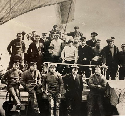
Slide 18 shows photographs of Shackleton’s remaining crew waiting on Elephant island for a rescue. Once Shackleton reached Stromness, he commandeered a ship to return to Elephant Island. Despite several setbacks, the Yelcho eventually became the ship to make safe passage and effect the rescue. All of the men were still alive and were rescued.
Challenge pupils to write a front page news story about the event. They will need to think about the headline and add photographs and quotes. This could be an individual or group effort. If the latter, pupils could attempt a full front page spread and include a timeline of rescue events and a map.
Historic News
Slide 19 has extracts of the report of Shackleton’s death. Despite having returned safely home to see his family, he was again on an expedition when he died of a heart attack on January 30 2022 as he prepared to land at South Georgia.
Using the links to the archived Guardian newspaper report of Shackleton’s death, ask pupils to read the report and work in pairs or small groups to take notes. Make this a timed activity and have a discussion about what the key questions are that they might want answered. Afterwards, the notes could be written up or given as verbal feedback during a plenary. (KS2).
E.g.
-
What are the facts?
-
What happened, where and when?
-
What does the report tell us about the status of Shackleton at that time? How important a public figure was he and what does this evidence tell us?
-
How reliable is this evidence source?
-
What other evidence sources might we look at?
Slides 20 and 21 are there to remind us of the crew of the Endurance and the Aurora and their role in this part of history. Shackleton went on to rescue men stranded from the Aurora too
Taking it further
Ask pupils to research the story of the Aurora. This was the twin expedition ship that was to supply Shackleton from the other side of Antarctica.Was this ship saved? Did all their crew survive?
Then and Now
Explore other changes between exploration in the early part of the 20th century and the that of the 21st century. See PPT Then and Now.
Explorers then and now
Slide 3. If you haven’t already looked at the film showing young explorers paying homage to the epic hike to Stromness, watch and compare how modern day adventurers fare.
Slide 4 shows crew members of the Agulhas II from the Endurance 22 expedition, discussing weather conditions. Compare this with the jotted notes and calculations made by Worsley.
Can a boat be famous?
Slide 5 shows two images of the James Caird lifeboat. One image shows it being launched on what might be the most epic journey a small boat has ever done. The other image shows the boat fully repaired and painted, and well preserved, on display at Dulwich college, where it can be visited.
Discuss this boat’s fame. Is it justified? It is likely pupils will agree that it is and recognise it has a historical value and signifies something inspirational but if there is disagreement it could prove to be an interesting debate.
Pose the question that if so much care and attention can be given to a wooden boat, should not the entire continent of Antarctica be protected in much the same way? Or its inhabitants, the wildlife?
Discuss whether we as humans give more protection to man – made objects than natural ones? Should there be a balance? Invite pupils to make observations and ask questions.
Climate change, Ice Change
Slide 6 show an animated view of ice mas change in Antarctica over the last 20 years. The source is reliable (NASA) and the consensus is that rapid changes in the global climate are being caused by human activity. While global climate has always undergone changes in the past, it is the speed of this change that is especially concerning as it means that most species are unable to adapt and survive. Neither can people around the world adapt to changing conditions that directly affect their livelihood and well-being, whether this is growing crops, accessing fresh water or surviving in extreme weather conditions.
Slide 7 introduces Argo Buoys. These are robot devices that can move through the water and collect important information about the state of the oceans. They are cheaper and more sustainable to run than having lots of ships sailing around the oceans doing this job. Because climate heating is real, and as the oceans store 90% of excess heat, it is important to monitor changes and where these are happening the fastest so that potential can be better understood.
Slide 8 shows the cycle of a buoy. Talk through it in simple terms with pupils.
Slide 9 shows the Adopt a Buoy project run as part of the Endurance 22 work. In partnership with Dr. Tamaryn Morris and Thomas Mtontsi from the South African Weather Service, Reach the World matched 11 schools in North America with 11 schools in South Africa and Namibia to name and “adopt” an Argo smart buoy and collaborate on classroom projects using the data collected by those buoys in the weeks following deployment. Each participating classroom received a video of their buoy being dedicated and deployed from the S.A. Agulhas II en route to the Weddell Sea.
Fieldwork
Ask pupils how they might monitor climate change in their school. We might not all have access to an ocean but what else can we do to measure the changing climate?
Through discussion, elicit ideas about simple data that could be collected. This could be gathering everyday weather and seasonal data from the school grounds and establishing dates of significance to build a yearly record (first Daffodil, first snow etc) (KS1). It might be more complex gathering and analysis of weather data or it might be gathering data about the school carbon footprint via travel to school data or school meals for example (KS2).
After gathering data think about what it can tell you about changing climate and what actions might be taken to mitigate and adapt. Pupils could draw up an action plan. This is important otherwise it is gathering data for its own sake without a real purpose and action to follow it up.
Slide 11 reminds us of the joyful finding of the Endurance
See the assembly idea too: Endurance
Vocabulary: see the PowerPoint for glossaries.
Curriculum Links
Geography: Key stage 1
Pupils should develop knowledge about the world, the United Kingdom and their locality. They should understand basic subject-specific vocabulary relating to human and physical geography and begin to use geographical skills, including mapping, to enhance their locational awareness.
Pupils should be taught to:
Locational knowledge
-
name and locate the world’s seven continents and five oceans
Human and physical geography
-
Identify the location of hot and cold areas of the world in relation to the Equator and the North and South Poles.
-
use basic geographical vocabulary
-
understand that there are different patterns of weather associated with seasons.
Geography: Key Stage 2
Locational knowledge
-
locate the world’s countries,
-
identify the position and significance of latitude, longitude, Equator, Northern Hemisphere, Southern Hemisphere, Arctic and Antarctic Circle.
History : Key stage 1
Pupils should develop an awareness of the past, using common words and phrases relating to the passing of time.
-
know where the people and events they study fit within a chronological framework and identify similarities and differences between ways of life in different periods.
-
use a wide vocabulary of everyday historical terms.
-
ask and answer questions, choosing and using parts of stories and other sources to show that they know and understand key features of events.
-
understand some of the ways in which we find out about the past and identify different ways in which it is represented.
Pupils should be taught about:
-
events beyond living memory that are significant nationally or globally
-
the lives of significant individuals in the past who have contributed to national and international achievements. Some should be used to compare aspects of life in different periods.
History Key Stage 2
Pupils should continue to develop a chronologically secure knowledge and understanding of British, local and world history, establishing clear narratives within and across the periods they study. They should note connections, contrasts and trends over time and develop the appropriate use of historical terms. They should regularly address and sometimes devise historically valid questions about change, cause, similarity and difference, and significance. They should construct informed responses that involve thoughtful selection and organisation of relevant historical information. They should understand how our knowledge of the past is constructed from a range of sources.
Pupils should be taught about:
-
a study of an aspect or theme in British history that extends pupils’ chronological knowledge beyond 1066
Links to other Areas of learning
English: speaking and listening, opportunities for reports, creative writing and descriptive writing, diaries, letters, lists and labels.
Mathematics: opportunities to measure, record, and to create and present data
Art and Design: know how art and design both reflect and shape our history, and contribute to the culture, creativity and wealth of our nation. Develop own ideas and techniques for drawing and painting.
Science: weather and climate
Other Web Links
-
Understanding climate: Antarctic sea ice extent | NOAA Climate.gov
-
How Antarctica Has Changed since Shackleton's 1915 Shipwreck - Scientific American
-
South: The Story of Shackleton's Last Expedition (1914-1917) by Sir Ernest Shackleton (Author)
-
Understanding the Navigation of the James Caird Lars Bergman George Huxtable, Bradley R Morris Robin G Stuart