Future places
Geography is not only up-to-date and relevant, it is one of the most exciting, adventurous and valuable subjects to study today. So many of the world's current problems boil down to geography, and need the geographers of the future to help us understand them.Michael Palin, letter promoting GCSE and A level geography
This lesson focuses on appreciating everyday wonder in the locality and considering what we want our place to be like in the future. Studying a locality in depth helps children appreciate how and why places are changing and how they can influence the possible futures that lie ahead. Learning about interactions between human, physical and environmental aspects of the world, leads children to realise the importance of decision-making and lifestyle choices in how places change for better or worse. Once children get to know their local place and form attachments, they are more invested in its future – and their role in that.
Teacher notes
This lesson can build on, or be developed, into a unit of work around fieldwork. Ideally, children will have explored their local area in some depth, looking closely to find the wonder in the everyday and appreciating what is special about one or more features where they live. Children then begin to think what special features and places in their locality might look like in the future, and why. Most importantly, they consider what they would like it to look like and realise that they have some influence.
Key questions
What is special about our locality?
What do we like and why?
What would we change?
Who else lives in this place?
What makes a healthy environment?
What will this feature / place probably be like in ten (25, 100) years’ time?
What could it possibly be like?
What would we prefer it to be like?
How do our choices affect how and why places are changing?
Presentation: Lesson 5 (See PPT Stay Home 5 Future places)
Getting started
Recap any fieldwork or exploration in class about the local are that has been done and identify what pupils like and don’t like. At this point, if these have not already been discovered and identified it may be the opportunity to develop fieldwork to find out. There re several slides in the presentation that give ideas about how this might be done with some examples of techniques. Develop the idea of the word wonder which has dual meaning: it describes something that astonishes and surprises but is also about ‘wondering’ and questioning. What everyday wonders are there in the locality? All Saints Primary School in Gresford, set out to identify and research a different local wonder in each class in a combined fieldwork study they called the 12 Wonders of Gresford. You don’t have to go that far but there is the scope to investigate at this scale.
If you have already identified some ‘wonders’ you could develop ideas about what makes places special using a sustainable framework that considers people, environment and economy and how well these are balanced.
If you are developing fieldwork at this point, use an enquiry approach to build on what you already know about the local area or a particular feature of it. Use factual information and other basic knowledge to develop some good enquiry questions. You could then decide what data gathering techniques might be best employed and how this might be done.
If you have already completed fieldwork, you can then develop the idea of ‘probable, possible and preferred’ futures. Start here by discussing the True or False statements on slide 13 – all of which are ‘true’ – to discover what children think.
Possible Activities
-
Locality fieldwork to investigate what is special, using the school grounds or wider afield.
-
Identify reasons why places are special, thinking about people, other living things and the environment, and how people might make a living. Use a grid such as that on the ppt to present answers and ideas.
-
Use photographs and maps to identify change in the locality and consider what it would probably be like in the future.
-
Draw, model, map and / or write about a vision for change – what a feature or place could be like in the future.
Taking it further
-
Present ideas about local wonders or visions for the future in a class assembly / write to the local paper / create a display and presentation for other classes or parents to see.
-
Invite a local MP or local dignitary in to answer questions about local change.
-
Identify some do-able change for the better that can be done in the school grounds. Map it, describe it and action it.
-
Investigate and map some other wonders around the world (KS1) and investigate changes and why they are happening in other places in the UK or wider world (KS2). Powerpoint 5 has a short film detailing changes taken in a city in Colombia to combat extreme heat that had beneficial effects for the environment and local people.(KS2)
-
Use locality studies as part of the comparison study at a local scale in KS1 with a non – European country and at a regional scale in KS2 within either N or S America and Europe.
-
Create a sequence of changes over time using different examples of change caused by human and physical processes such as earthquakes, volcanoes, river erosion, mountain building, climate change etc and organise by time e.g. which changes might happen in a day, which over decades, which over millions of years.
-
Create manifesto of sustainable change for your school, identifying actions for a healthy planet.
Vocabulary (See Stay Home 5 Future places Vocabulary)
NC links KS1 and 2 geography
KS1
Place knowledge
understand geographical similarities and differences through studying the human and physical geography of a small area of the United Kingdom, and of a small area in a contrasting non-European country
Human and physical geography
use basic geographical vocabulary to refer to:
-
key physical features, including: beach, cliff, coast, forest, hill, mountain, sea, ocean, river, soil, valley, vegetation, season and weather;
-
key human features, including: city, town, village, factory, farm, house, office, port, harbour and shop
Geographical skills and fieldwork
-
use simple compass directions (North, South, East and West) and locational and directional language [for example, near and far; left and right], to describe the location of features and routes on a map
-
use aerial photographs and plan perspectives to recognise landmarks and basic human and physical features; devise a simple map; and use and construct basic symbols in a key
-
use simple fieldwork and observational skills to study the geography of their school and its grounds and the key human and physical features of its surrounding environment.
KS2
Locational knowledge
-
name and locate counties and cities of the United Kingdom, geographical regions and their identifying human and physical characteristics, key topographical features (including hills, mountains, coasts and rivers), and land-use patterns; and understand how some of these aspects have changed over time
Place knowledge
-
understand geographical similarities and differences through the study of human and physical geography of a region of the United Kingdom, a region in a European country, and a region within North or South America
Human and physical geography
describe and understand key aspects of:
-
physical geography, including: climate zones, biomes and vegetation belts, rivers, mountains, volcanoes and earthquakes, and the water cycle
-
human geography, including: types of settlement and land use, economic activity including trade links, and the distribution of natural resources including energy, food, minerals and water
Geographical skills and fieldwork
-
use maps, atlases, globes and digital/computer mapping to locate countries and describe features studied
-
use the eight points of a compass, four and six-figure grid references, symbols and key (including the use of Ordnance Survey maps) to build their knowledge of the United Kingdom and the wider world
-
use fieldwork to observe, measure, record and present the human and physical features in the local area using a range of methods, including sketch maps, plans and graphs, and digital technologies.
Links to other areas of learning
English: reading, writing, speaking and listening;
Mathematics: handling and presenting data
Science – adaptation and habitats
RE: investigating special places and their importance in our everyday lives.
Weblinks
About the project: stories
During these extraordinary times, our homes have never been more important. Through the ‘Stay Home’ collecting project the Museum of Home in East London is inviting people across the UK and beyond to submit images, written words, audios and videos of their experiences of home during the COVID-19 pandemic.
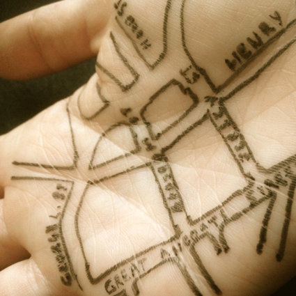
About the project: maps
The Mapping Home strand of the ‘Stay Home’ project is asking children and young people to draw a map of home. By asking them to express these spaces on paper, we hope to gain a better understanding of how their experience of the home space may have changed during the COVID-19 restrictions. The maps act as a tool for supporting children and young people in sharing knowledge of their unique experiential expertise of COVID-19 onto paper.
Submit your maps
Please submit your Stay Home maps through Stay Home – we are really interested to see what you have created!