
Management to reduce the effects of a tectonic hazard
The way in which many places attempt to reduce the risk posed by hazards of any kind is to use all or a combination of the following:
Monitoring
This consists of the use of specific technologies to watch over areas which are particularly susceptible to tectonic events and to record certain types of data.
In the case of volcanoes, tiltmeters, for example, can be used to detect the changes in the level of the ground as some volcanoes are known to bulge before an eruption. Seismometers can also be used to detect movements of magma beneath the ground, gases can be monitored, as changes in these can indicate impending activity, and thermal imagery from satellites can be used to see if volcanoes are starting to heat-up.
Earthquakes are a little trickier to monitor, as they often occur without warning. One of the keyways that scientists do try to monitor them, however, is by measuring tectonic plate movements. This is undertaken by a network of GPS stations installed in tectonically active regions, which allows scientists to measure plate movements. Where plates continually move, it suggests tensions at plate boundaries are continuously relieved, preventing buildup and associated earthquakes. However, where plates may not seem to be moving, it might suggest they are locked, pressures are building, and that the potential for an earthquake could be increasing.
Gas sensors for both earthquakes and volcanoes are useful monitoring tools as radon gas increases and/or is released before an earthquake or volcanic eruption.
Prediction
Prediction works hand in hand with monitoring, with scientists taking the monitoring data and trying to work out what it shows.
For volcanoes, what scientists look for are changes in the data that is being collected. For example, if a volcano starts to bulge, heats up, if gas emissions change or if the numbers of tremors increase, it might indicate that the volcano is becoming unstable and that an eruption is imminent.
Without clear indicators of impending earthquakes, their prediction is much more difficult, and scientists often prefer to use the term ‘forecast’. In such cases, scientists will take the data they have monitored, look at when past events have occurred, and then use this information to forecast when and where an earthquake might occur, usually over a long time period. For example, scientists might forecast that there is the chance of an earthquake occurring in a particular location, within the next 30 years. What shows more potential however, are Early Warning Systems (EWS). Once an earthquake happens, seismic waves are sent out from the focus, and the less-destructive P-waves shoot out at speed. If automated EWSs can detect these P-waves quickly enough, then they can send warnings out to people in the vicinity that the more destructive surface waves will be arriving imminently. Japan and Mexico have such systems in place, and they have been successfully used a number of times.
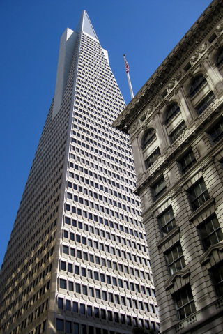
Figure 6: Transamerica Pyramid San Francisco © Wally Gobetz Flickr
Protection consists of the construction of infrastructure that can withstand a tectonic event. One way in which this can be done is to design buildings that can withstand the shaking from an earthquake. The Transamerica Pyramid (pictured above) in San Francisco is an excellent example of this. It is built with a base larger than its top therefore, increasing the stability of the building. Triangles are one of the most solid shapes and so anything shaped this way will be stronger than a cube. Engineers have also added other features in buildings such as isolators built into the foundations to absorb some of the shaking, counterweights suspended in the upper floors to correct the building’s sway and lattice work on the outside to stabilise the building.
Planning
Methods are available to help people be ready for a tectonic event, or to ensure that when they happen, their impacts are not as bad as they could be. There are many densely populated areas in the world which experience regular earthquakes. Japan is one of these places which have over 1,500 earthquakes each year. To help the population prepare for such an event, Japan holds a Disaster Prevention Day every 1st September. On this day, the population practices evacuation drills, firefighting, emergency meetings, hospital drills, and much more. Other earthquake prone areas such as California in the US encourage its citizens to have emergency kits at home to help survive after an earthquake has hit and provide grants for people to strengthen their homes. Also in California, planning regulations are in place which prevent the construction of new buildings within designated distances from known fault lines.