The specification
AQA A Level 3.2.1.5.1 Antarctica as a global common. Demonstrate the role as a global common and illustrate its vulnerability to global economic pressures and environmental change.
Edexcel A Level 6.8.c. Threats to ocean health pose threats to human wellbeing, especially in developing regions that depend on marine resources as a food source and for tourism and coastal protection.
OCR A Level Topic 3.3 – Exploring Oceans. 2.c. Governing the oceans poses issues for the management of resources.
WJEC A Level 3.2.6 to 3.2.10: Global Governance of the Earth’s Oceans. Laws and agreements regulating the use of the Earth’s oceans in ways that promote sustainable economic growth and geopolitical stability.
The tragedy of the commons
Oceans are a part of the ‘global commons’ – a term which describes an area with the potential for tragedy when there is little control over the way the common resources, such as fish stocks, are accessed and used. The expected outcome is a decline in resources when the rate of use exceeds the rate of natural replacement and regeneration. This leads to over-exploitation, depletion, degradation and ultimately scarcity.
The metaphor refers to areas which lie outside the political reach of nation-states. There are four global commons: the high seas, the Antarctic, the atmosphere, and outer space. These areas are largely uncharted, unregulated, and ungoverned. They are therefore in special need of being managed and protected.
-
Fishing is found in all the world’s oceans – in open international waters – unless it is close to land in exclusive economic zones. As no single country ‘owns’ the ocean or the resources in them, it is a global common, which is very vulnerable to exploitation.
-
Equally, adventure tourism to the global commons is growing. For example, tourist numbers are steadily increasing to Antarctica and remote holiday destinations, such as the South Pacific Pitcairn Islands.
As a result, ocean pollution is increasing around the world due to a combination of fishing, marine plastic pollution, travel, tourism, and development.
2022 is dubbed a ‘super year’ for the world’s oceans, with several key international summits set to occur, (the G7, the Convention on Biological Diversity COP15, and the United Nations Framework Convention on Climate Change). The 2020s are also the UN Decade of Ocean Science.
In response to the threats to the global commons, the UK government initiated the Blue Belt initiative in 2016 to support UK Overseas Territories to enhance the protection and management of their surrounding marine environments.
The hope is that the initiative is a starting point for further conservation efforts around the world – with the UK government calling upon the global community to build on the initial effort by committing to protect 30% of all the world’s oceans by 2030. These marine areas will be conserved and titled as MPAs (marine protected areas). They are designed to protect and conserve marine life and its habitats by restricting activities such as fishing, resource extraction, and mass tourism.
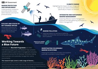
Figure 1 the purpose of MPAs © Joe Wells CEFAS
What is the Blue Belt Programme?
The Blue Belt programme set out to support the protection of 4 million km² of ocean around the UK Overseas Territories. There are 7 key territories around the world which have come under this protection, namely: Ascension Island, British Antarctic Territory, British Indian Ocean Territory, South Georgia and the South Sandwich Islands, Pitcairn Islands, Saint Helena, and Tristan da Cunha.
These overseas territories have made massive commitments to protect their waters for biodiversity, sustainable fishing, and for future conservation. Reducing the detrimental impact of human activity has been an important facet of the programme. Jane Rumble OBE, Head of the FCDO’s Polar Regions Department, explains:
We are having a demonstrable effect on those marine environments. You can see where there have been improvements – including the return of species, more abundance, cleaner oceans, better resilience to climate change.
The Blue Belt Programme demonstrates the major role that small, remote islands can have in achieving global change.
There are 3 islands in the Atlantic Ocean which collectively form the British Overseas Territory of Saint Helena, Ascension, and Tristan da Cunha. These landmasses are volcanic islands formed by the divergent plate boundary of the mid-Atlantic Ridge. Each of these territories has a 370-kilometre Exclusive Economic Zone (EEZ) extending out from the islands’ territorial sea baseline.
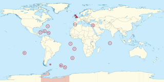
Figure 2 a blank map of the British Overseas Territories Wikimedia
Within the EEZ the UK has exclusive rights to explore, exploit, conserve, or manage sovereign natural resources. This covers both living and non-living resources, the seabed, and the superjacent water. Exploration and exploitation might involve energy production, fishing, or tourism. In these particular territories marine conservation has been selected to protect biodiversity, strengthen governance, manage human impacts and sustainable fisheries, and to enforce compliance of the Blue Belt.
In the following sections the British Overseas Territories of St Helena, Ascension, and Tristan da Cunha will all be examined as small Blue Belt examples. In the cases of St Helena and Ascension data is provided on Atlantic tuna habitats. This dataset is extracted from Climate Change Impacts on Atlantic Oceanic Island Tuna Fisheries – a collection of scientific papers titled Working Towards a Blue Future.
St Helena
St Helena is the second oldest overseas territory and a tropical island, with an area of only 121 km². It is famous for two things: being one of the most remote islands in the world and the location for the imprisonment of Napoleon Bonaparte, who was exiled there in 1815. Known as ‘the Galapagos of the South Atlantic’ the island has historically been an important stopover for vessels rounding The Cape of Hope (and the African continent).
Until 2018, RMS Helena (the last ship still carrying the status of a Royal Mail ship) brought goods and mail to the island every 3 weeks.
When Charles Darwin visited St Helena aboard HMS Beagle in 1836, he remarked that ‘the island rises abruptly like a huge black castle from the ocean’.
Whilst visiting in 1836, Darwin studied the island’s volcanic behaviour and became very interested in how islands were created. He used his observations from his visit to St Helena to form the first academic hypothesis that volcanoes form from slow rising, gradual and episodic events, which finally erupt to create an island.
The waters around St Helena are a habitat for hundreds of dolphins and ocean tuna. It is also a really important whale shark site. Since 2016, as a result of the Blue Belt classification, there is now a strong legal framework in place in order to set up a marine tourism policy for the island. This is seen by many as a key future industry.
Table 1 below shows the average weather of St Helena, including Sea temp °C and Hours of daylight, to compare against Ascension (Table 3), and Tristan da Cunha (Table 5). The data helps to build a profile for each of the islands.
|
St Helena |
J |
F |
M |
A |
M |
J |
J |
A |
S |
O |
N |
D |
|
Average max °C |
27 |
27 |
28 |
27 |
24 |
23 |
22 |
22 |
22 |
23 |
23 |
24 |
|
Average mean °C |
24 |
24 |
24 |
24 |
22 |
21 |
20 |
20 |
20 |
20 |
21 |
22 |
|
Average min °C |
21 |
21 |
22 |
21 |
19 |
18 |
17 |
17 |
17 |
18 |
18 |
19 |
|
Sea temp °C |
15 |
15 |
15 |
19 |
23 |
27 |
28 |
28 |
27 |
23 |
18 |
16 |
|
|
|
|
|
|
|
|
|
|
|
|
|
|
|
Precipitation mm |
8 |
10 |
20 |
10 |
18 |
18 |
33 |
10 |
5 |
2 |
0 |
3 |
|
No. of wet days |
4 |
4 |
5 |
3 |
4 |
6 |
8 |
3 |
2 |
1 |
0 |
1 |
|
|
|
|
|
|
|
|
|
|
|
|
|
|
|
Hours of daylight |
13 |
12 |
12 |
11 |
11 |
11 |
11 |
11 |
12 |
12 |
12 |
13 |
|
Rel. humidity % |
63 |
65 |
64 |
65 |
72 |
72 |
74 |
76 |
75 |
72 |
72 |
65 |
Table 1 Jamestown, expected weather statistics, St Helena Island Info
International tourists visit St Helena for the dark skies, endmic wildlife, and the opportunities to hike on a warm isolated island (yearly mean 21°C). Once regarded as ‘the best-kept secret in the South Atlantic’ St Helena is now well-known and there is growing concern about the impact of climate change and unregulated tourism on the marine environment.
As a result, a number of marine studies have been undertaken to assess the future impact of climate change. Table 2 below shows the projected impact on the different species of Atlantic tuna with future RCP4.5 and RCP8.5 scenarios to 2050.
|
Atlantic tuna species around St Helena |
Suitable habitat present day |
Habitat change medium emissions scenario 2050 |
Habitat change high emissions scenario 2050 |
Total future suitable habitat medium emissions 2050 |
Total future suitable habitat high emissions 2050 |
|
Southern bluefin |
237.0123431 |
-49.18265098 |
-79.21284436 |
187.8296921 |
157.7994988 |
|
Albacore |
257.6995009 |
90.57220116 |
186.444201 |
348.2717021 |
444.143702 |
|
Yellowfin |
242.5747391 |
149.0750196 |
271.7288082 |
391.6497587 |
514.3035474 |
|
Bigeye |
267.2012379 |
192.3912238 |
319.999521 |
459.5924618 |
587.2007589 |
|
Skipjack |
161.9206967 |
199.7019081 |
397.5399786 |
361.6226047 |
559.4606753 |
Table 2 St Helena’s projected suitable habitat for Atlantic tuna 2050 © Dr Bryony Townhill CEFAS Blue Belts*
It is the southern bluefin tuna which will see a decrease in suitable habitat around St Helena. Whilst all other species will see an increase, particularly the skipjack tuna.
*The data used the Maxent model whereby each grid cell shows the degree of habitat suitability on a scale of 0 to 1, with 0 being not suitable at all, and 1 being completely suitable. It can be thought of like a probability. The total suitability is then this number for all of the grid cells in the waters of St Helena or Ascension added together. Consequently, the datasets doesn’t have a unit.
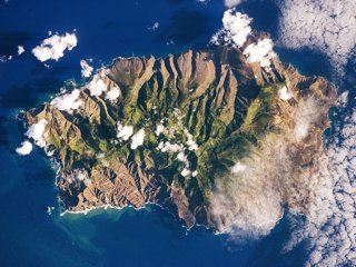
Figure 3 St Helena © NASA Earth Observatory
Ascension
Ascension is an unusual British Overseas territory as the UK government does not allow right of abode on the island, therefore, all 800 British citizens of Ascension are only ‘temporary visitors’ officially. Located halfway between Brazil and Africa, the summers on this island are short, hot, and oppressive whilst winters have uncomfortably high humidity.
Due to its isolation, volcanology, and exposure to the ocean Ascension was once renowned for being desolate – devoid of flora and fauna. At one time it was reported that there was only a single, solitary tree on Ascension. However, in the 19th century, a naturalist called Joseph Hooker brought in non-native species to create the world’s first ‘artificial ecosystem’, which has since threatened the small amount of native vegetation on the island.
The surrounding marine environment is described as globally important. Examples of the island’s exceptional biodiversity are green turtles, Galapagos sharks, and Atlantic tuna. Ascension Island Council hope that the MPA will repeat the success of the green turtle conservation, which began in the 1970s (after decades of ‘harvesting’ by passing ships).
Since the instigation of the MPA in 2019, commercial fishing and extractive industries have been prohibited, allowing, for example, birds like the Sooty Tern to re-establish around the island (after years of over-fishing Atlantic tuna).
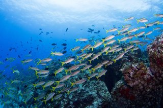
Figure 4 in 2019 Ascension Island MPA was designated © J Brown Ascension Island Government
Like St Helena, Ascension is a tropical island. The waters around the island are warm with an average sea temperature of 26°C. They teem with marine life. As a result there is again concern that the delicate marine ecocystem surrounding the island will be altered by the impacts of climate change. For example, the ‘deadly trio’ of heat, acidity, and loss of oxygen will damage the habitat for Atlantic tuna and many other species.
Increasing sea temperature and ocean acidification will pose a serious threat to the island’s limited number of scleractinian corals (there are no coral reefs) and the abundant marine life which enjoy the nutrient-rich waters such as surgeonfish, longfin crevalle jack, squirrelfish, sergeant-majors and the black triggerfish (one of Ascension’s best known species).
|
Ascension |
J |
F |
M |
A |
M |
J |
J |
A |
S |
O |
N |
D |
|
Average max °C |
28 |
29 |
30 |
30 |
29 |
28 |
27 |
26 |
26 |
26 |
27 |
27 |
|
Average mean °C |
26 |
27 |
27 |
27 |
27 |
26 |
25 |
24 |
24 |
24 |
24 |
25 |
|
Average min °C |
24 |
25 |
26 |
26 |
25 |
24 |
23 |
23 |
22 |
22 |
23 |
23 |
|
Sea temp °C |
26 |
27 |
28 |
28 |
27 |
26 |
26 |
25 |
24 |
24 |
25 |
25 |
|
|
|
|
|
|
|
|
|
|
|
|
|
|
|
Precipitation mm |
0.5 |
0.9 |
2.5 |
3.7 |
2.1 |
1.0 |
0.2 |
0.4 |
0.1 |
0 |
0 |
0.2 |
|
No. of wet days |
2 |
2 |
6 |
9 |
5 |
1 |
1 |
1 |
0 |
0 |
0 |
1 |
|
|
|
|
|
|
|
|
|
|
|
|
|
|
|
Hours of daylight |
12 |
12 |
12 |
11 |
11 |
11 |
11 |
11 |
12 |
12 |
12 |
12 |
|
Rel. humidity % |
90 |
99 |
100 |
100 |
99 |
89 |
63 |
42 |
42 |
41 |
54 |
71 |
Table 3 climate data on RAF Ascension Island, WeatherSpark
|
Atlantic tuna species around Ascension |
Suitable habitat present day |
Habitat change medium emissions scenario 2050 |
Habitat change high emissions scenario 2050 |
Total future suitable habitat medium emissions 2050 |
Total future suitable habitat high emissions 2050 |
|
Southern bluefin |
266.0491273 |
-64.77538121 |
-106.786049 |
201.2737461 |
159.2630783 |
|
Albacore |
232.7107052 |
83.43057209 |
169.4581103 |
316.1412773 |
402.1688155 |
|
Yellowfin |
226.9134418 |
165.8858757 |
274.6747407 |
392.7993175 |
501.5881825 |
|
Bigeye |
191.20338 |
191.9264457 |
330.8246757 |
383.1298257 |
522.0280557 |
|
Skipjack |
151.8376979 |
211.2637305 |
359.5886312 |
363.1014284 |
511.4263291 |
Table 4 Ascension’s projected suitable habitat for Atlantic tuna 2050 © Dr Bryony Townhill CEFAS Blue Belts*
Around Ascension, the southern bluefin is again anticipated to suffer the most habitat change. The albacore, yellowfin, bigeye, and skipjack are all likely to benefit from an increase in marine habitat.
Tristan da Cunha
Tristan da Cunha is an archipelago with its main village, Edinburgh of the Seven Seas, renowned as the world’s most remote settlement on Earth. There is no airport, and no deep harbour. The island lies roughly halfway between Buenos Aires, in Argentina, and Cape Town, in South Africa – even now getting there requires a 7-day journey at sea. The island is so remote that only 7 surnames still exist, among a population of only 241 people.
The MPA that surrounds the 4 main islands of Tristan da Cunha is the largest ‘no-take’ area in the Atlantic. 90% of the island’s waters are closed to fishing and other extractive activities. The total area stretches across an enormous 700,000 km² and, crucially, hosts a number of endemic species.
The nearby Isle of Nightingale, part of the archipelago, is home to rockhopper penguins, known by Tristan islanders as ‘Pinnamin’ and the 3 endemic Tristan albatrosses, which breed on the island: Atlantic yellow-nosed albatross, sooty albatross, and the Tristan wandering albatross.
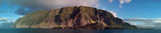
Figure 5 Tristan da Cunha © Brian Gratwicke Flickr
In spite of being on the same latitude as Melbourne in Australia, the climate of the island is a cool temperate oceanic one due to the cooling effect of the surrounding sea in the summer (with a maximum of 18°C in February) and the reverse (warming effect) happening in winter when sea temperatures only drop to 13°C. Due to these favourable and mild conditions the northern rockhopper penguin, which is only on a few islands in the Atlantic, is found in abundance on Tristan da Cunha – 99% of the population make the island their home.
Tristan da Cunha recieves a high level of precipitation throughout the year with an average of 140mm per month. As climate change is expected to alter ocean weather patterns (and ocean currents) in the future Tristan da Cunha will be severely impacted.
It is an important area in the South Atlantic as the island archipelago lies in the convergence zone between subtropical and Southern Ocean currents. Changes to the convergence zone will alter the species-rich waters which are currently home to blue sharks, cold-water coral, the Tristan rock lobster (foundational to the Tristan economy), whales (Southern Right, Fin, Humpback, Antarctic Minke, Sperm, and Orcas), dolphins, Antarctic fur, elephant seals, and seabirds.
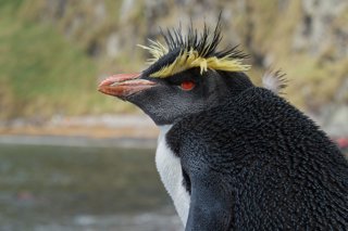
Figure 6 the famous Rockhopper penguins on Inaccessible Island, Tristan da Cunha © Brian Gratwicke Flickr
|
Tristan da Cunha |
J |
F |
M |
A |
M |
J |
J |
A |
S |
O |
N |
D |
|
Average max °C |
14 |
14 |
14 |
15 |
17 |
19 |
20 |
21 |
20 |
18 |
17 |
15 |
|
Average mean °C |
12.5 |
12 |
12 |
13 |
15 |
17 |
18 |
19 |
18 |
16.5 |
15 |
13 |
|
Average min °C |
11 |
10 |
10 |
11 |
13 |
15 |
16 |
17 |
16 |
15 |
13 |
11 |
|
Sea temp °C |
14 |
13 |
13 |
14 |
15 |
16 |
17 |
18 |
18 |
17 |
16 |
15 |
|
|
|
|
|
|
|
|
|
|
|
|
|
|
|
Precipitation mm |
160 |
175 |
169 |
151 |
128 |
127 |
93 |
113 |
121 |
129 |
155 |
160 |
|
No. of wet days |
25 |
26 |
24 |
22 |
18 |
19 |
18 |
16 |
17 |
20 |
23 |
23 |
|
|
|
|
|
|
|
|
|
|
|
|
|
|
|
Hours of daylight |
10 |
11 |
12 |
13 |
14 |
14.5 |
14 |
13 |
12 |
11 |
10 |
9.5 |
|
Rel. humidity % |
79 |
79 |
78 |
79 |
79 |
80 |
79 |
77 |
75 |
78 |
78 |
79 |
Table 5 Tristan da Cunha’s climate, the Tristan Government and the Tristan Association
Another threat to the marine ecosystem of Tristan da Cunha are ship wrecks. The last major disaster occurred in 2011 when the MS Oliva ran aground releasing 800 tonnes of fuel. This significantly affected the local northern rockhopper penguin population on the Isle of Nightingale.
As a result of this event, and the fact that some cruise ships now visit, plus the more recent sinking of the MFV Geo Searcher in 2020 (a fishing vessel which sank off Gouch Island) an island monitoring system has been set up to track ships and human activity within the newly designated Areas to be Avoided.
Activity
-
Use an atlas to map the 7 territories involved in the Blue Belt Programme onto Figure 2.
-
The St Helena website explains ‘it can be bright, sunny and hot in Jamestown while simultaneously cold and wet in Longwood. A single forecast can rarely be correct for every possible location’. Can you explain why the weather is so variable across the island?
-
Create a factfile on the famous giant green turtles of Ascension.
-
Everything on Tristan da Cunha ‘depends on the weather’. Create a climate graph to visualise the yearly changes.
-
Repeat this task for St Helena and Ascension.
-
Due to climate change, how might weather and climate alter on St Helena, Ascension, and Tristan da Cunha?
-
-
There is concern about the impact of climate change on Atlantic tuna around these remote islands. Using the medium emissions scenario for St Helena, create a line graph to show how the habitat for the 5 different types of tuna will change from now until 2050.
-
Repeat this task for Ascension.
-
-
Create a spider diagram for the positives impacts from the Blue Belt programme. Are there any negatives?
Further reading
-
GOV.UK Blue Belt annual report 2021
-
The Blue Belt Programme video explainer
-
Climate Change Impacts on Atlantic Oceanic Island Tuna Fisheries from a collection of scientific papers titled Working Towards a Blue Future
-
The Guardian St Helena’s airport finally ready for touchdown
-
DW documentary: St Helena – a remote island in the Atlantic
-
National Geographical Ascension
-
Ascension Island Government The Sooty Tern
-
Scientific American The Unusual Abundance of Ascension Island
-
The Guardian Tristan da Cunha islanders rescue rockhopper penguins threatened by oil
-
Tristan da Cunha website Tristan's Climate in a Nutshell
-
Tristan da Cunha Wildlife and conservation
-
Tristan da Cunha Island at the End of the World
-
Pew By Protecting Its Ocean, Tristan da Cunha Safeguards Its Future
This resource was first published in 2022.