What is a cyclone?
A cyclone is the same as a hurricane or typhoon. Its name indicates which ocean it is in. Cyclones, hurricanes and typhoons are all weather events called tropical cyclones. A cyclone is a tropical storm that forms in the Indian Ocean. If you would like to learn more about the distinction between these classifications, the BBC Bitesize webpage What are cyclones, hurricanes and typhoons? explains the differences between these ‘powerful spinning storms’.
What happened last month?
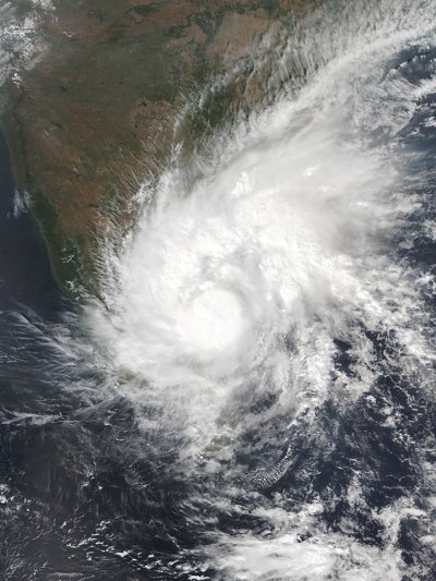
In November 2020, a cyclone called Nivar hit India, only the third cyclone to make landfall since May earlier this year (when storm Amphan hit south east Asia, the biggest cyclone in two decades).
Cyclone Nivar is a severe tropical cyclone which formed in the Bay of Bengal and struck the southeast coast of India between 26 and 28 November 2020. The tropical cyclone struck Puducherry, a district in Tamil Nadu, with a population of 1.6 million people.
After making landfall at around 10.30 pm on 25 November, cyclone Nivar weakened from ‘very severe’ to only ‘a severe cyclonic storm’ and moved northwards inland. It particularly effected Chennai in Tamil Nadu and Andhra Pradesh further up the coast.
Warnings were issued to coastal areas and fishermen were advised not to go out to sea.
The Hindustan Times reported that ‘independent scientists said warming of oceans due to climate change was leading to more intense cyclones and dangerous storm surges’ in the Bay of Bengal.
‘Now we have a La Nina in the Pacific, that is cool conditions in the Pacific that makes the local environmental conditions favourable for cyclogenesis in the Bay of Bengal. During the last 40 years, six cyclones of the severest cyclone category, hit the Tamil Nadu coast in November. Out of these six, five of them coincided with La Nina like conditions in the Pacific.’
What were the impacts?
A cyclone can lead to a huge loss of life and property, especially in low-lying areas. The Indian Meteorological Service forecast winds of between 120 to 130 kilometres per hour (75 to 81 miles per hour), flooding, damage to crops and plantations, destruction of buildings and roads, disruption to power lines and the uprooting of trees.
The Bay of Bengal hosts only 4% of the total tropical cyclones globally but suffers of the fatalities are from this region.
Cyclone Nivar claimed four lives and several injured, with heavy rainfall, a 1 metre storm surge, fallen trees, blocked waterways and toppled electricity pylons making rescue operations difficult.
What was the Indian response?
The National Herald of India reported on 24 November that the Puducherry district administration imposed prohibitory orders to stop the movement of people in public, issuing the directive under Section 144 CrPc. This was later rescinded by 26 November.
On 25 November before the cyclone made landfall, mass evacuations were coordinated by Indian authorities in the low-lying areas of south eastern India. Around 2,000 people were evacuated in Puducherry alone.
National Disaster Response Force (NDRF) rescue teams have been deployed with over 1000+ personnel mobilised specifically trying to encourage people to move to safer zones, away from vulnerable coastal villages. The NDRF is a disaster-response agency in India. It is the largest singular and specialised disaster force in the world. They are largely deployed for floods, cyclones, building collapse and earthquakes in India.
Advice from the NDRF was broadcast in 3 simple pieces of information; Are you cyclone ready? Switch off electrical gas/gas supply, keep doors and windows shut, rely only on official warnings.
There were an estimated 175,000 people in rescue shelters by Wednesday night, 25 November.
The government in Tamil Nadu open sluice gates in a lake near Chennai as a precautionary measure against metropolitan flooding in the city. The authorities also declared a public holiday on Thursday, 26 November to limit travel and avoid the disastrous flooding of 2015 when 400 people were killed.
Sizeable environmental destruction also occurred with over 1000 trees being uprooted by the storm.
Mathematics and Data Skills
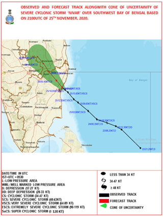
Can you chart the course of cyclone Nivar? If you can it would be an excellent test of both numeracy and your knowledge of latitude and longitude. Use this Administrative map of India © Nations Online Project (which helpful identifies Puducherry, where cyclone Nivar made landfall) and this table data © Weather Underground, to chart how this tropical storm developed.
An example of a complete cyclone tracker map © The India Meteorological Department is below to illustrate how it should look.
Alternatively, sketch the choropleth map for Thursday 25 November below © the Weather Channel. It shows the amount of rainfall in mm after cyclone Nivar made landfall. Can you replicate the colour coded data?
Further reading
Nivar makes landfall India: Cyclone Nivar makes landfall bringing rains, flood | India | Al Jazeera
Emergency ban on gatherings declared as storm bears down on Indian city Cyclone Nivar: Emergency ban on gatherings declared as storm bears down on Indian city | The Independent
Landfall triggers torrential downpours Cyclone Nivar: Landfall triggers torrential downpours - BBC News
One dead and torrential rains as huge storm surge makes landfall in India Cyclone Nivar: One dead and torrential rains as huge storm makes landfall in India | The Independent
Prohibitory orders clamped in Puducherry to restrict movement of people Cyclone Nivar: Prohibitory orders clamped in Puducherry to restrict movement of people (nationalheraldindia.com)
Tens of thousands evacuated in southeast India Cyclone Nivar: Tens of thousands evacuated in southeast India | News | DW | 25.11.2020
Over 1000 trees unrooted, say officials Cyclone Nivar live updates | Over 1,000 trees uprooted, say officials - The Hindu