She specialises the study of glacial environments and is interested in the sensitivity of glaciers to climate change. Kathryn is also the editor of the online climate science outreach website www.climatica.org.uk. We spoke to Kathryn about her experiences in researching glaciers and the importance of understanding glacial change.
How did you become interested in researching glaciers?
I first developed an interest in glaciers and climate change issues when I was in school. I was fascinated by glacial environments, not only due to the scale of these systems and their ability to engulf the landscape, but also due to their sensitivity to change. It was not until part way through my undergraduate degree (in Physical Geography) that I managed to see a glacier first hand. I was travelling with a friend in Patagonia and took a trip to Torres del Paine National Park. We managed to take a boat out onto the proglacial lake in front of Grey Glacier and sail up to the ice front. The glacier did not look as I had imagined at all! It was bright blue in colour, not like the white that I had seen in diagrams and photos, and the glacier snout was highly crevassed and contained a lot of debris (sands and gravels). It was this experience that really developed my interest in glacial processes, and how their advance and retreat can impact on meltwater systems downstream.
How are Mediterranean glaciers different from glaciers elsewhere?
During the remainder of my degree I developed an interest in past glacial environments, looking at the long-term response of meltwater systems to changes in glacial advance and retreat. This takes into account multiple glacial-interglacial cycles during the Quaternary period (the last ‘Ice Age’ over the last 2.6 million years). To look at these long-term archives of glacial system behaviour we often have to move away from areas that are currently glaciated (such as high latitude polar regions, or high altitude mountainous settings), to regions that are no longer occupied by ice. This ensures that we can access the glacial geomorphological record. The Mediterranean is a particularly valuable location for this. Contrary to what we might expect, the mountains of the Mediterranean contained large ice caps and valley glaciers during the glacial stages of the Quaternary. This includes the major ice caps in the Alps and the Pyrenees, but also smaller ice masses in the high mountains of Greece, Italy, and Turkey, for example. The retreat of the ice means that glacial features such as cirques, moraines, and glacially-scoured bedrock are well preserved. We now have records of Mediterranean glaciation spanning several glacial cycles over the last few hundred thousand years.
Unlike the large ice sheets that developed across northern Europe during the Quaternary period, the Mediterranean ice masses were highly sensitive to environmental change. This is due to their location at relatively low latitudes, which are much warmer than northern Europe. This means that, under the influence of a warming climate, these glaciers would have responded very rapidly to environmental change. An additional case study of past glaciation of the Drakensberg Mountains, southern Africa is available.
Why is it important to study glaciers?
Understanding glacial dynamics is an important part of earth science research for a number of reasons. Ice masses are very sensitive to global temperature changes. The predicted increases in temperature will have considerable impacts on the rate of glacial retreat. The melting of ice caps and glaciers, as well as the large polar ice sheets, will lead to significant increases in global sea level. Evidence suggests that ice caps and valley glaciers alone account for 50% of the land ice contribution to sea level rise in the 20th Century. The study of past and present glacial processes allows us to more fully understand the response of the cryosphere to environmental change, and establish the impacts on other parts of the earth system - including the hydrosphere, biosphere, and atmosphere. What is more, a large proportion of the global population rely on glacial meltwater as their primary water source. While these meltwater resources may increase in abundance in the short-term (under current glacial retreat), it is important to establish the long-term implications of climate change on water resources if glaciers disappear altogether.
Why are changes in glaciers in the Quaternary period important?
The Quaternary glacial record provides a valuable opportunity to assess long-term glacier behaviour in response to major climatic shifts. We now have evidence of glacial activity (in the form of glacial landforms such as moraines, and glacial sediments) going back several hundred thousand years. We can establish the age of these deposits using techniques such as radiocarbon, uranium-series, and cosmogenic nuclide dating (which identifies how long a rock may have been exposed at or near the earth’s surface). These are all based on the radioactive decay of isotopes as a geological stopwatch. Once we have dated the glacial deposits, we can compare and correlate them to other records of global climate change, such as the ice core record, marine sediments, and pollen records. This allows us to explore regional patterns in glacial activity in relation to wider environmental changes.
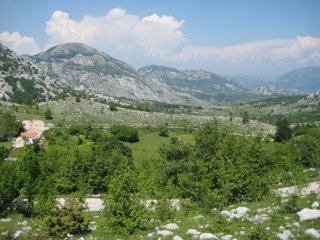
Fieldwork in Montenegro – a moraine can be seen here as a ridge in the centre of the photograph. Image credit: Kathryn Adamson
It is important to place current changes in glacier behaviour into a longer-term context. This allows us to establish whether the changes that we see at the present day are ‘normal’ for these glacial systems, or whether they represent a major shift in glacial dynamics. It is only by investigating how glaciers have behaved during previous glacial and interglacial phases that we accurately predict how they may respond to future climate change scenarios. Using records of past glacial change, we can test our theories of glacial processes and use these to inform our understanding of present and future environments.
What kinds of methods do you use in your research?
My research involves a combination of field and laboratory methods. In the field, we complete geomorphological maps of glacial and river features - to establish the impacts of these systems on landscape morphology. This typically involves measuring and describing the features, and plotting their positions using a GPS. We also assess the characteristics of glacial and river deposits using ’sedimentology’ - this incorporates detailed descriptions of sediment structures, colour, and texture. Together, geomorphology and sedimentology can provide important details on glacial and fluvial dynamics such as: the size of the glacier, its thermal regime, the direction of flow, and the competence of meltwater streams. We often take samples of the sediments to analyse in more detail in the laboratory.
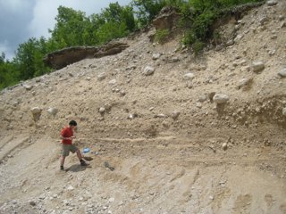
Fieldwork in Montenegro – here you can see river sediments with glacial sediments on top. Image credit: Kathryn Adamson
In the laboratory we have a range of techniques available to us. There are ‘particle size’ machines to analyse the size of the sediment grains. This provides important information on the sediment transport and depositional processes operating in the glacial and fluvial environment. We can investigate the mineral composition of the sediments so that we can establish the source of the glacial sediments - different types of rocks (lithologies) originate from different locations. Analysing the source of these rocks can provide important information on glacier flow - it is a kind of sediment ‘fingerprinting’.
We also use the laboratory to analyse our samples for dating the glacial deposits. In the field we might take samples from a boulder on a moraine or from sand deposits in front of a glacier. These then undergo a series of chemical preparation procedures to purify the samples, so that we can date them using radiocarbon, uranium-series, and cosmogenic nuclide methods, for example. We then combine all of these field and laboratory measurements to try and establish the timing of glacial activity, the size of the glaciers, and the impacts of glacial behaviour on landscape erosion and river systems downstream.
What kinds of evidence did you need to find in your fieldwork?
When we are out in the field we are looking for both glacial erosional and depositional features. Erosional features might include: ice moulded bedrock, cirques, roches moutonnées, whale backs, P-forms, and striations. Depositional features include: moraines, outwash fans, protalus ramparts, and eskers. These are all diagnostic features of glacial activity, and indicate that the landscape has been occupied by ice at some time in the past. These allow us to map the dimensions of the former glacier by indicating how far down valley the ice would have extended, and how thick the ice may have reached. Where possible we also look for natural exposures into the depositional features, for example where a stream might have cut into the moraines, and the sediments are exposed for us to analyse. Where this is not possible we look for suitable places to dig out cross sections into the deposits using a spade. The sediments can tell us a good deal about the processes operating in the glacial environment - different processes lead to very different sediment characteristics. To date the timing of glacial activity we can use several lines of evidence. For cosmogenic nuclide dating we are looking for large boulders or areas of ice moulded bedrock where we can take chippings for chemical analysis in the laboratory. For radiocarbon (14C) dating we might look for organic material buried within the sediments.
Do you have a favourite glacier?
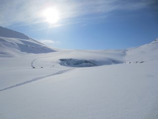
The Debeli Namet glacier in the Prokletije Mountains, on the border of Montenegro and Albania is one of my favourite glaciers. It is only 0.05 km2 in size but is one of the few active glaciers in this part of Europe. During the last Ice Age much larger glaciers developed over these mountains. As the climate warmed at the end of the ice age, the ice retreated and many of these glaciers have now disappeared.
Do you have a favourite geography fieldwork moment?
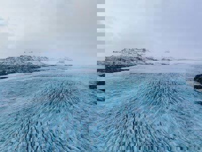
Fieldwork is one of the many perks of research. Each field season is very different, and I have a lot of very memorable moments. One of my favourites from recent years is the 2013 summer field season on Disko Island in Greenland. We had spent over 10 hours hiking to our field site, wading through meltwater streams, and trekking past ice caps and outlet glaciers. The 24-hour daylight meant that we could continue walking for such a long period, and we finally arrived at about 10pm. We needed to make some measurements on the meltwater stream the following day, and so pitched up our tent right in front of the glacier snout (ensuring that we were at a safe distance from the meltwater stream, in the instance of a meltwater flood). The following morning, waking up, climbing out of my tent and eating my breakfast porridge sat at the ice front is something I will never forget.
An Ice Cap in Disko Island, Greenland. Image credit: Kathryn Adamson
Glossary:
Cirque: a steep bowl-shaped hollow occurring at the upper end of a mountain valley.
Crevasse: a deep crack in an ice sheet or glacier
Cryosphere: the part of the Earth's surface covered by frozen water (ice caps, glaciers etc.) and frozen ground (permafrost).
Esker: a long narrow ridge composed of stratified sediment, marking the former location of a glacial tunnel.
Geomorphology: the study of landforms and the processes that shape them.
Glacial-interglacial cycle: the periodic switch between cooler global temperatures causing large ice sheets and glacial advance, known as glacial periods (or ice ages) and times of warmer global temperatures, with less glacial presence known as interglacial periods.
Ice shelf: a thick floating platform of ice that forms where a glacier or ice sheet flows down to a coastline and onto the ocean surface.
Landscape morphology: the form and structure of the landscape.
Moraines: accumulation of boulders, stones, or other debris carried and deposited by a glacier typically as ridges at its edges or extremity.
Outwash fan: a fan-shaped body of sediments deposited by braided streams from a melting glacier.
Proglacial lake: a lake formed by the damming action of moraine in front of a glacier as the glacier melts.
Protalus rampart: mound or ridge formed from broken rocks lying at an angle at the foot of a wall.
Roche moutonnée: bare outcrop of rock shaped by glacial erosion so that one side is smooth and gently sloping whilst the other is steep, rough and irregular.
Sedimentology: study of modern sediments such as sand, mud (silt), and clay, and the processes that result in their deposition
Striations: a series of parallel ridges, furrows or linear marks.
Whaleback: bedrock which has been smoothed and rounded on all sides by a glacier.
Kathryn was interviewed in February 2014