Chesil Beach
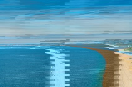
Chesil Beach is an 18 mile (29km) long, 200 metre wide and 18 metre high shingle tombolo in Dorset
Background information
Chesil Beach, sometimes called Chesil Bank by locals, is an 18 mile (29km) long, 200 metre wide and 18 metre high shingle tombolo in Dorset, southern England. The beach is part of the Jurassic Coast World Heritage Site.
The tombolo of Chesil Beach connects the Isle of Portland, a limestone island in the English channel to Abbotsbury, though it continues westwards to West Bay near Bridport. It is the largest tombolo in the United Kingdom and it forms a large lagoon (the Fleet) on its shoreward side. The beach is steep, showing a clear storm beach. Pebbles on the beach are graded, with the coarser stones nearer to Portland. Fishermen familiar with the beach claim to be able to tell their location from pebble size alone. The pebbles are mainly flint and chert from the Cretaceous and Jurassic rocks which make up this stretch of the Heritage Coast, along with bunter pebbles, possibly from Budleigh Salterton, although no universally accepted geological theory has been formulated to explain the mode of transport.
At the Isle of Portland end of the beach, the beach curves round sharply to form Chesil Cove. This part of the beach protects the low lying village of Chiswell from flooding.
The beach provides shelter from the prevailing winds and waves for the town of Weymouth and the village of Chiswell, which otherwise would probably not exist.
From West Bay to Cliff End the beach is piled up against the cliff. At Cliff End a hollow forms behind the beach and at Abbotsbury a stretch of muddy saline (or brackish) water called the Fleet (a lagoon) begins. The Fleet is home to many wading birds and Abbotsbury Swannery, and fossils can be found in the sand.
Both Chesil Beach and the Fleet Lagoon are a Site of Special Scientific Interest, whilst the view of the beach from Abbotsbury has been voted by Country Life magazine as Britain's third best view.
Formation of Chesil is still under debate but the favoured theory is that it is a product of glacial outwash. A forerunner probably existed several miles offshore 120,000 years ago. Rising sea levels caused erosion of deposits and wave action drove the material towards the mainland in the direction of the prevailing wind forming the beach we see today.
Sea defences at Chiswell
Sea defences have been constructed at intervals at the Portland end of the Chesil Beach to try to alleviate the overtopping and flooding problems, and fairly recently a flood drainage channel scheme has been dug. Artificial changes to the world-famous, natural geomorphological feature of the Chesil Bank have strongly opposed, but, nevertheless, the existence of a village behind a beach which the sea at intervals overcomes has inevitably resulted in the engineering developments. The existing housing has been present there for a long time and needed some protection, but any further housing development in the area will undoubtedly result in due course in further damaging and costly sea defences.
Site overview
Chesil Beach - Beach processes: Key points
-
What feature is Chesil Beach and what reasons have been suggested for its formation?
-
How do coastal processes affect beach structure?
-
How does beach material vary across a storm beach?
-
The importance of Chesil beach as a natural defence
-
How can physical environments be managed to preserve their characteristics yet meet people's need for recreation
Project/hypothesis ideas
-
Is there a relationship between pebble size and angle of the beach?
-
Does longshore drift will cause a lateral grading of sediment along the beach in the direction of the prevailing wind?
-
Too many visitors to a honeypot site can do as much damage as natural erosion
-
What are the impacts of the management schemes on Chesil?
Tips/pitfalls
-
Make sure that the profile follows a straight line, have a third ranging pole or spot on the horizon to line up with
-
Shield gun clinometers from the wind
-
When measuring pebble size collect them at random to avoid altering the results with the biggest prettiest colour ones
Data collection
-
Coastal processes
-
Beach profiles
-
Pebble analysis
-
Longshore drift
-
Wave angle
-
Management
-
Questionnaires
-
Environmental impact surveys
-
Field sketches
-
Review - Statistical
-
Chi squared - Pebble size, distance along beach
Review - Presentation
-
Profiles
-
Bi-polar surveys
-
Longshore drift graphs
Chesil Beach - Chiswell sea defences: Key points
-
To discover the causes, consequences and solutions for a coastal flood event
-
How often has Chiswell flooded in the past and what were the consequences of this (social, economic, environmental)?
-
What management techniques have been put in place to prevent flooding?
-
What were the costs and benefits of the scheme?
-
Has the scheme been successful?
Project/hypothesis ideas
-
Do the land-use patterns of Chiswell reflect the problems of flooding?
-
Marine processes which operate in this area and need to be controlled for the sake of the residents, (the benefits of coastal defences outweigh their costs)
-
How do you think global warming might affect storms and flooding at Chiswell in the future?
Tips/pitfalls
-
Profiling tips as above
-
If possible visit the site during stormy weather conditions to see the flooding potential
Data collection
-
Sea defences
-
Profiles
-
Questionnaires
-
Environmental quality survey
-
Photographs
-
Field sketches
-
Cost benefit analysis of sea defences
-
Land use maps
-
Review - Presentation
-
Profiles
-
Bi-polar surveys
360 view of Chesil beach (MPG). Copyright Sarah Robinson
Longshore drift (MPG). Copyright Stuart Hitch
Video showing the formation of shoreline cusps on Chesil Beach by Stuart Morris
File nameFiles
File type
Size
Download