River Wey
The River Wey is one of the smallest river systems in England
The River System
The River Wey is one of the smallest river systems in England. It is 8.8km long, but for its short length is has a comparatively large surface catchment area of 47.6 km2. Laterally, it falls 60 metres from source to mouth, resulting in a gradient of one in 150.
The River Wey is typical of a small to medium, spring-fed chalk stream with gravel bed and a moderate flow. Over its course, it passes through a great variety of landscapes and environments. It rises beneath the chalk escarpment that overlooks Weymouth and quickly descends through the countryside to the urban fringe and the suburbs and then into Weymouth itself. Towards the end of its course the river fills a large lake (Radipole Lake), now designated a nature reserve, right in the centre of town. The Westham Bridge effectively dams the river and is intended to prevent salt water ingress reaching too far upriver. Thereafter the river flows through a marina and the port of Weymouth with its cross-channel ferries to its estuary and the sea.
Geology
The chalk escarpment rises steeply above head of the Wey valley at Upwey. Towards the base of the escarpment, near to the spring, the Purbeck Beds are exposed. A well defined ridge of Portland limestone runs from Upwey to Portesham. It is into this band and that of the Portland sands that the River Wey has incised its steep sided asymmetrical valley above the Wishing Well. At Littlemore the river reaches the vale of Kimmeridge Clay which lasts until the gap that it has cut through the Corallian ridge, crossing the Weymouth lowland. On the Southern side of this ridge the river crosses Oxford Clay. The main road into Weymouth is sited on an interfluvial ridge of Oxford Clay. Weymouth itself is built on the Oxford clay lowland. The river drains into Radipole Lake, which was formed in the Late Quaternary marine transgression.
Economic and social history
The economic and social history of the valley has long been dependent upon the river. It is believed the Romans used Radipole Lake as a harbour and route to Dorchester via Upwey was of major importance. There were five mills on the river. Upwey, Broadwey, Nottington and two at Radipole. Until this century the mill owners were probably the most important body as far as human management of the river is concerned. The mills could only operate when the river flowed six inches below the bottom blades of the mill. In order to keep all five mills working simultaneously the mill owners had to coordinate closely to maintain the river at the requisite level. It could be argued that the modern unitary authorities fail to manage the rivers as closely and effectively as those whose livelihood depended on the health of the river.
The Upwey Wishing Well is recognised as the source of the River Wey, and the pumping station at Friar Waddon draws from the source. It extracts a tremendous amount of water. Wessex Water has a licence to extract up to 14 million megalitres a day here, and this water supplies the Isle of Portland. In 1988 the upper half of the Wey dried up.
The flows from the springs initially serve the Upwey fish farm which has been in operation since 1976 and immediately downstream Upwey water mill, which was restored to commercial operation in 1987 (but closed in 1992). In 1989 a flow gauging station began monitoring the river regime above the fish farm in response to low flow and fluctuating water flows. The fish farm is famous for its watercress beds with are evidence of good quality water. Any water used by the fish farm has to be pumped back into the river.
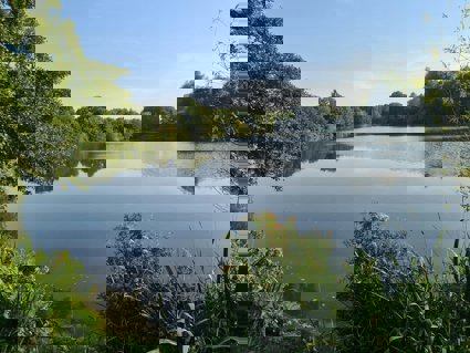
Radipole Lake
Radipole Lake covers an area of 86.8 hectares (215 acres). It consists of an extended area of reed beds as well as open water and is separated from the inner harbour by a sluice gate system which helps control the water levels within the lake. It is an SSSI and has been managed by the RSPB since 1979. the lake attracts 45,000 visitors a year and is staffed by a warden and assistants. Radipole Lake was created by the Late Quaternary marine transgression when the lower parts of the river valley were submerged forming a lake surrounded by intertidal mudflats. The Westham Bridge hatches were built in the 1920s to prevent Spring Tide flooding upstream. However their continued use is controversial as flooding still occurs and the exclusion of the spring tides has meant silting up of the lake has increased. This is effectively the mouth of the river.
Site overview
Fluvial Systems - River Wey
Key points
-
The River Wey drainage basin
-
What are the main features of the geology and hydrology of the Wey Valley?
-
What physical factors and processes influence channel characteristics as you move downstream?
-
Interaction between people and fluvial environments
-
The issues and management strategies which arise from the influence of people on the river system
Project/hypothesis ideas
-
How and why do velocity and channel area vary downstream?
-
How and why do sediment size and discharge vary downstream?
-
How and why does the wetted perimeter vary with distance from source?
-
How does canalisation affect the morphology and flow characteristics compared to an unmanaged section?
-
How does water extraction for public use influence discharge rates at the source of the River Wey?
-
How do some of the activities within the Wey Valley impact upon the management issues dealt with at the RSPB Reserve?
Tips/pitfalls
-
Make sure that all sites are labelled and site descriptions made, especially if sharing data
-
Make sure that all groups start measuring from the same side of the bank
-
Keep tape out of river so it is not dragged downstream effecting results
-
When measuring depth turn the rule side on so that the river flow does not affect readings
-
Have at least two people record results in case they are lost/dropped in the river etc.
Data collection
-
Measure
-
Width
-
Depth
-
Wetted perimeter
-
Velocity
-
Bedload size
-
-
Calculate
-
Cross-sectional area
-
Discharge
-
Hydraulic radius (efficiency)
-
Review - Statistical
-
Spearman's rank - velocity and cross sectional area
-
Spearman's rank - efficiency and cross sectional area
-
Spearman's rank - bedload size and efficiency
Review - Presentation
-
Cross sections of river
-
Isopleth map - velocity of river
-
Annotated sketches - meander
-
Histograms - bedload size
File nameFiles
File type
Size
Download