La Palma is a small island in the Atlantic Ocean. It is part of a Spanish archipelago called the Canary islands. La Palma is the most north-westerly of the seven islands, situated only 445 km away from the African coast.
More than one-third of the island is protected as a UNESCO World Biosphere Reserve, earning La Palma the nickname Isla Bonita, meaning the beautiful island. It is a designated Starlight Reserve with perfect conditions to view the stars.
However, it is also home to a stratovolcano volcano, which lies on an active volcanic ridge. It has erupted 8 times since 1470 (when records began) with the last major eruption being in 1971.
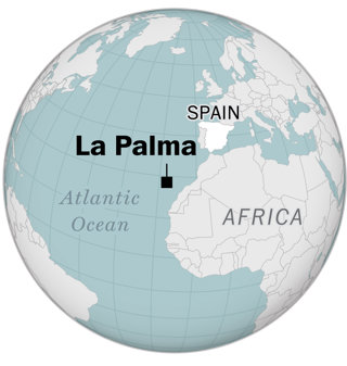
Figure 1 © Washington Post
The Cumbre Vieja volcano
The stratovolcano on the island of La Palma is called the Cumbre Vieja volcano. The volcano recently erupted on 19 September 2021 and continues to erupt. Its summit is 2426 m above sea level. Since September the volcano has exhibited Strombolian activity, meaning explosions have been violent, with volcanic tephra, ash falls, episodic blasts of ‘pasty’ lava, and lava fountaining.
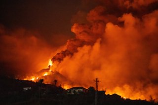
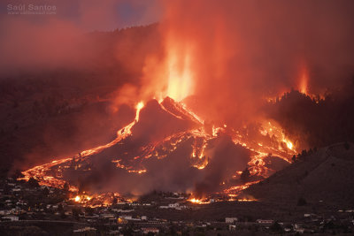
Figure 2 the Cumbre Vieja volcano. Lava has now destroyed over 2,651 buildings on the island © VP68
Figure 2 shows the ‘advancing and sometimes branching lava flows’ from Cumbre Vieja. These lava flows, combined with sulphur dioxide emissions which peaked at 50,000 tonnes p/d (recorded on 23 September), have necessitated mass evacuations on the island. At least 7,000 people have now been evacuated with 2,651 buildings having been destroyed.
The Canaries Islands are located on the African Plate and are near a passive continental plate margin. It is believed the volcanoes of the archipelago probably formed above a fixed hotspot and they have since been dragged eastwards away from the Mid-Atlantic ridge. The lava from the Cumbre Vieja volcano is therefore a basaltic eruption, creating low silica, and low viscosity (resistance to flow) lava. Gases are allowed to escape due to the low viscosity, which authorities are monitoring with people in the coastal towns of San Borondon, Tazacorte, and El Cardon all being told to stay indoors due to poor air quality. The town of La Laguna was evacuated in November.
- Watch a fly-by in Google Earth across the La Palma island and Cumbre Vieja volcano (2020)
- Watch some drone footage of the eruption from Global News (October)
- Watch 3D global scene and drone imagery from ESRI and complete the eruption GIS task
3 out of 7 lava flows have now crossed the island and reached the sea, after 9 days of progression. There have been no deaths and a high levels of property loss and damage to infrastructure. For example, La Palma airport closed 21-23 November, and access from the southern highway to the coast has also been closed, as lava flows continue to approach the coast of Tazacorte.
Since Monday, 29 November, new lava tubes have sent molten lava flowing downhill at approximately 1 metre per second.
A significant amount of lava has already reached the sea, cooling rapidly, and releasing toxic gases and a highly acidic ‘lava haze’ which can cause acid rain. If blown inland this poses health risks such as skin and eye irritation and breathing problems to island inhabitants. According to the Copernicus satellite 43 hectares of new land have been created, which you can visualise from this ESRI drone imagery of the lava flow to create 3D scenes in your browser.
Further work
-
La Palma is a fissure eruption Twitter video
-
ITV News 'We don't dare make predictions'
-
CNN Fast flowing lava from Spain's La Palma volcano continues to wreak havoc more than 2 months on
-
Euronews See how Spanish island has grown 43 hectares since eruption
-
The Times La Palma volcano: lava reaches the coast and forms giant pyramid in sea
-
The Washington Post A small home was left untouched by the Canary Islands volcano eruption. Social media is calling it a ‘miracle’
-
The Smithsonian Institution Global Volcanism Program: La Palma
-
USGS basalt glossary
-
Scripps Institute of Oceanography On the ground at the La Palma eruption