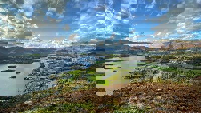
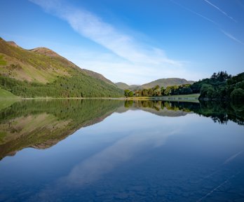
The Lake District National Park in Cumbria was established in 1951 in recognition of its unique combination of spectacular mountains and fells, wooded valleys, lakes and tarns. It covers 2,292 km2, and has a population of just over 42,000. The diverse landscape of the Lake District, along with its significant tourism industry (10 million day visitors arrive each year), lends itself to a wide variety of fieldwork opportunities.
These pages provide you with background to the geography, geomorphology and geology of the National Park, with links to sources of further information and details about the fieldwork that can be carried out in different areas of the park. In addition, you will find some ideas for relevant investigations, including the influence of Beatrix Potter's literature on tourism in the Lake District.
Background information
National Parks are areas that have been recognised for their unique landscape qualities. Each one has its own managing authority to conserve and enhance its natural beauty, wildlife and cultural heritage and to help people to understand and enjoy its special qualities. There are currently 14 National Parks in Great Britain, and an additional one pending in the South Downs. Unlike in some other parts of the world National Parks in Britain are not owned by the government and are places where a wide variety of people live and work. The first two National Parks to be designated were the Peak District and the Lake District.
The Lake District National Park
The Lake District National Park, in the county of Cumbria, was established in 1951 in recognition of its unique combination of spectacular mountains and fells, wooded valleys, lakes and tarns. It covers 2,292 km2, and has a population of just over 42,000.
The Lake District National Park Authority and their partners have developed a ‘vision' for the future, encompassing a prosperous economy, vibrant communities, a spectacular landscape and world class visitor experience.
Geology
Most of the National Park comprises three broad bands of rock trending from SW to NE, the Skiddaw Group in the northwest, formed about 500 million years ago, is mainly metamorphosed mudstones. The Borrowdale Volcanic Group, outcrops in central Lake District, and is mainly lavas and ash flows erupted during a cataclysmic period of vulcanism, 450 million years ago. The Windermere Group which outcrops in the southeast of the National Park, includes slates, siltstones, sandstones and limestones formed in shallow tropical seas. All these rocks are underlain by a batholith of granite which led to their uplift into a central dome of mountains. (Source)
Geomorphology
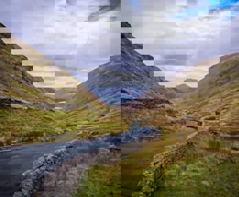
Central Lake District is occupied by a glaciated massif of mountains and ridges intersected by wide, steep-sided ‘U' shaped valleys often occupied by ribbon lakes. The southern Lake District fringes are typified by limestone ridges flanked by wooded slopes and lake-filled valleys. On the mountain fringes the fells give way to more muted scenery; low hills and valleys often filled by drumlin suites. The coast is a mixture of sandstone cliffs and depositional dunes, which also occur in the south along the fringes of wide, silt filled estuaries with large tidal ranges.
Glaciation
About two million years ago, the Lake District was a mountain massif broken by river valleys radiating outwards from the centre. A period of climatic oscillations led to a series of ice ages during which the ice flowed out from the central core, following the river valleys, deepening and widening them, and depositing streamlined till and other depositional features on the lower land. As a result, the Lake District is a text book example of glacial landforms.
Soils
The most important factor in the development of Lake District soils is the downward leaching of water as a result of high rainfall. Rainfall amounts vary considerably across the Lake District National Park. Seathwaite receives an average of 3300 mm per year while down the valley Keswick receives about 1470 mm per year. What makes the National Park especially wet and the rainfall more intense is the process of relief (orographic) rainfall caused by the upland area of fells. The young, characteristically shallow, acid, stony soils formed of glacial till found in the high fells are known as rankers. Excessive leaching led to the formation of podsols: pale, sandy bands beneath the organic horizon, often underlain by an iron pans. Brown Earths, loesses and rendzinas occur over the foothills of the Lake District where drainage is improved, and marine sediments can be found around the shores of Morecambe Bay.
History
The Lake District has been inhabited since the Stone Age. The first inhabitants were hunter-gatherers, but by Neolithic times, farming began, and land was cleared to make room for crops and grazing animals. By the 13th century, the wool trade had become firmly established together with charcoal burning for smelters and hydro power for mills. In post medieval times, the minerals and rocks of the Lake District were being exploited, leading to the development of new transport routes. The success of the woollen industry meant more and more of the open fells became enclosed for sheep grazing. Woodland coppicing was practiced for bobbin manufacture, and charcoal was an important ingredient for gunpowder, manufactured on several sites in south Cumbria from 1764 onwards.
The building of the railways during the Victorian period, and later motorways and private car ownership led to the development of tourism as the Lake District became more accessible. Tourism has developed as the area's major industry. To protect the area is became a National Park in 1951.
Mining and quarrying
There is evidence of mining and quarrying in Cumbria as early as the 12th Century, and possibly dating back to Roman times. Evidence of mining can be seen over a wide area, for minerals such as lead, copper, graphite, and coal. Slate mining and quarrying still take place, providing building material for dwellings. Further information.
Settlements
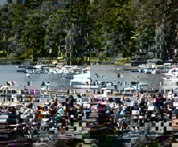
There are two major towns in the Lake District National Park, Keswick and Bowness on Windermere, both of which are urban honey pots. They are linked by the A591and are both accessed from the M6. There are several tourist towns, such as Ambleside, mostly located on good access routes, and many smaller villages and hamlets with limited tourism outlets whose history is connected more with agriculture and mining.
Kendal, which lies on the eastern fringe of the Lake District National Park and was the centre of the wool trade is now a tourist honey pot site and continues to be a market town. In the west, beyond the National Park boundary are Workington, a market and industrial town, and Whitehaven, a Georgian town, built on the shipping and mining industries.
Opportunities for fieldwork
The Lake District National Park, with its diverse landscape and tourism industry, lends itself to a wide variety of fieldwork opportunities. Additionally good roads and an abundance of car parks suitable for coaches make it readily accessible from the north via the M6 and A66, and from the south along the M6 and A591/592.
Key Stage 2
The National Park has many areas worthy of study, for example, a wide variety of settlements set in a contrasting mountain locality. There are excellent opportunities for studying rivers, suitable for younger pupils to explore, and for hands-on experience of the water cycle. The coast can be accessed on the periphery of the National Park in places like St. Bees and Walney Island, though these take longer to reach. Field trips to study the natural and built environment can be combined with ‘geography and numbers' to make an exciting and valuable day out. There are also limited opportunities to cover ‘improving the environment' with several wind farms in the area, and Sellafield nuclear power station on the west coast.
Key Stage 3/GCSE and at A level
The physical landscape offers opportunities for studying rivers and glaciation across a variety of sites, and has some sections of coast worth visiting. The central mountain core is within reach of good roads and car parks for either day or half-day excursions studying river systems or glaciated upland landscapes, whilst on the periphery there are sites suitable for studying coastal erosion and sand dunes. Good, accessible sites are available for the study of ecosystems.
With 14 million tourists visiting the Lake District National Park every year, many of the settlements have been influenced by tourism, so lend themselves to urban studies and human impacts. Many of the towns and villages are suitable for half day settlement studies to look at urban geography, human impacts and rural change. On their fringes are accessible sites for studying topics like footpath and lakeshore erosion. A visit to Sellafield nuclear power station could be combined with looking at a wind farm to cover the new energy unit. Several units could be combined to make a full day excursion.
Facilitating fieldwork
There are a number of options for facilitating field work within the Lake District National Park.
Field Studies Council Fieldwork provision in the Lake District National Park and environs
The Field Studies Council operate three centres in the area that provide opportunities for fieldwork in the National Park: Blencathra, near Keswick, Castle Head near Grange-over-Sands, both offer residential courses, these can work towards the three levels of the highly rated John Muir Awards combining adventure with the conservation of wild places.
The Education Service at Lake District Visitor Centre, Brockhole offers day and half day tutored modules for students through Key Stage 1 and Key Stage 2 to ‘A' level and beyond. These can be delivered directly at the field work sites or run from accommodation providers. The centre provides tutors who take responsibility for risk assessments and first aid and lead the fieldwork, which can be tailored to meet your specific requirements. The Lake District National Park Education Service also offers a free information service to support studies of the National Park and United Utilities What About Water days.
Maps of field sites
Find out about the opportunities for fieldwork in these different regions of the Lake District:
-
Bowness on Windermere
-
Buttermere Valley
-
Central Fells around Langdale
-
Coniston Fells
-
Eastern Fells, Glenridding
-
Keswick and Bassenthwaite
-
Northern Fells
-
Upper Borrowdale Valley
-
West Coast
Developing a sense of place in the Lake District
An introduction to the Lake District National Park: Developing a sense of place
The influence of Beatrix Potter tourism on the Lake District
Flopsy, Mopsy, Cottontail and Peter: How has Beatrix Potter influenced the Lake District?
Water management in the Lake District National Park
Assessing the Impact of Damming and Reservoirs: A post-16 fieldwork project