
Professor Dave Petley is Pro-Vice-Chancellor for Research and Enterprise at the University of East Anglia. His research as a geographer focuses on landslides, especially in high mountain areas in low income countries. He is particularly interested in the use of field monitoring and laboratory testing to understand the internal mechanisms of these mass movements. He also maintains a database and a blog of landslide events occurring worldwide. We talked to him about landslides, their causes and their risks.
Which parts of the world are most likely to witness landslides and why?
Landslides can occur in any environment in which there are steep slopes, so they are a truly global phenomenon. However, they are most likely to happen where certain combinations of circumstances occur – usually steep slopes, weak materials, active geological processes and large trigger events. This means that there are global landslide hotspots – the Himalayan region is the most important, but there are also significant landslide problems in large parts of East Asia (including China, Japan and Taiwan), in South East Asia (especially the Philippines and Indonesia), and in Central America and the Caribbean.
How can we measure landslides – do they have a numerical magnitude like earthquakes?
There is no simple numerical scale, and there are a number of ways to measure them. The simplest is termed the runout distance – in simple terms the distance that they travel. This is quite easy to measure but only really tells a part of the story. We can also use the surface area covered by the landslide, which is more useful but harder to measure. The best indicator is the volume of the landslide, but this is very hard to determine as measuring the depth of the landslide is extremely challenging without very detailed measurements in the field. But new satellite tools are becoming available that might make this much easier in the near future, so we may well be able to develop a true magnitude scale for the first time.
What actions of human beings have increased the likelihood of large landslides occurring?
Unfortunately humans are very efficient at causing landslides. We know from the archaeological record that as humans started to develop agriculture on slopes, causing deforestation, the frequency of landslides dramatically increased. This process continues today in many parts of the world. Through time we are also increasingly occupying steep slopes, and poor engineering practices in these areas are inducing many landslides. So, for example, in Nepal there has been a dramatic increase in landslides on hillslopes because poor quality road construction has led to extensive slope instability. This is avoidable for the most part.
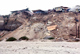
A landslide in San Clemente, 1966 (Source: Flickr Orange County Achives)
How might climate change affect the frequency and size of future landslides?
This is quite poorly investigated at the moment, and the effects are likely to be complex. But in general slopes are quite sensitive to increases in rainfall intensity (how heavy the rainfall is). There are strong signs from many places that as the atmosphere warms the intensity of rainfall is increasing, in particular for the heaviest rainfall events. So this is likely to mean an increase in landslide events in general, although in some places this may be reversed by a reduction in total annual rainfall. Globally we expect that the net effect will be an increase in landslide impacts.
What can people do to manage landslides more effectively in developing countries?
There are two simple rules for managing slopes. The first is to look after water carefully. In many cases this can be achieved with simple drains – Victorian engineers became masters at this, through trial and error, when building railway embankments. The same principles still apply. The second is to avoid making slopes too steep. It is sometimes necessary to cut slopes, but where this happens the gradient should be appropriate for that environment. If this gradient is exceeded then the slope needs to be supported, and there are lots of simple measures, such as retaining walls, that can be used to achieve this.
Can we model landslides for a particular place in a laboratory or can we only monitor its dynamics in the field?
Laboratory modelling has its uses, but it is very difficult (and expensive) to scale the stresses from the field to the laboratory. We tend to use lab work to understand material behaviour – in other words, how does the soil or rock deform - and then a combination of field monitoring and computer simulation to understand likely behaviour. Computers have become extremely powerful tools for simulating landslides, and this is a field that is developing quickly.
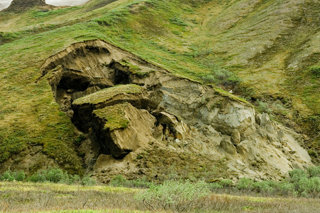
Landslide in Denali National Park, Alaska (Source: Flickr EDubya)
What role does ‘citizen science’ have in landslide research?
To date there has been only very limited use of citizen science in landslides, primarily because they are much harder to characterise than are volcanoes and earthquakes. However, the British Geological Survey, who manage the UK landslide database, now use Twitter to identify landslide events. This has dramatically increased the number of recorded landslides.
In 2013 you co-wrote a paper on earthquake induced landslides in Nepal. Many of your observations then came to life in the April 2015 earthquakes in the region. Is it difficult to study, and make predictions about, a subject where the scale of human loss can be so great?
We have been working on the potential for earthquake-induced landslides in Nepal for a decade. We still understand these landslides very poorly, so our estimates of what might happen were always very uncertain. The April 2015 event has triggered many landslides in the mountains, and there will be many more in the forthcoming monsoon. But so far the impacts, tragic though they are, have not been as bad as we feared. We are now trying to find out why this is the case.
Key Words
Deforestation
The removal of trees from a forested area.
Geology
A study of the physical structure and substance of the Earth, in particular the rocks that compose it
Landslide
The mass movement of rock and earth material at significant speed down a slope.
Lesson Ideas
Drawing on the idea that landslides occur as a result of linked factors, students can write a recipe for the most destructive landslide. They should consider the scale of each of the factors they are including as well as the location and the role humans have to play in the disaster.
Imaginging they are taking part in a ‘citizen science’ programme associated with landslides, students can draw up a list of changes they may notice in a hill side prior to a landslide happening as well as how they might monitor it without the use of any specialist equipment.
Researching a previous landslide featured on David’s blog, students can comment on how they might have reduced the damage it caused through management methods of their own design. They can then comment on how the outcome of that landslide may have been different if it had occurred with the same circumstances but in a different country or region.
Dave was interviewed in July 2015
- Case study
Nepal earthquakes, avalanches and landslides
On 25 April 2015, Nepal experienced a magnitude 7.8 earthquake, followed by an avalanche on Mount Everest, a second, 7.4 magnitude earthquake on 12 May 2015 in eastern Nepal, and numerous landslides and aftershocks.
- 60 second guide
Mass movement
- 60 second guide

The Rock Cycle