What’s the challenge?
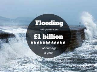
The Government has recognised flooding as one of the most serious threats facing the country, yet only the next six years of funding for flood-risk management, to 2021, is assured.
Flood, drought and heat wave: these are the three major natural threats that threaten London, the UK’s capital and a World City. In this 21st Century Challenge, we take a look at the nature of London’s flood risk and reasons why it is now widely accepted to be increasing.
Types of flooding
Groundwater flooding is caused by groundwater escaping from the ground when the water table rises to or above ground level. Groundwater tends to flow from areas where the ground level is high, to areas where the ground level is low. Groundwater flooding takes longer to dissipate because groundwater moves much slower that surface water and will take time to flow away underground. Damage from groundwater flooding is often self-inflicted. New development is frequently located on land naturally prone to flooding and flood cellars and converted into living space. Groundwater flooding is sporadic in time and location, but when it occurs it usually lasts longer than surface water flooding
Fluvial flooding occurs when rivers overflow and burst their banks, due to high or intense rainfall.
Surface water flooding occurs where high rainfall events exceed the drainage capacity in an area. Such events lead to serious flooding of property and possessions where surface water flows and collects. 3,000,000 properties are at risk from surface flooding in Enland. Surface flooding is caused by a combination of high rainfall and impervious land cover. A high amount of rainfall in a short period of time causes a fast accumulation of rain water. Impervious land cover stops the rain water from infiltrating through to the ground, therefore run off into the drainage area is rapid. Good urban planning and green space can help minimise the risk of surface water flooding.
Coastal flooding occurs when normally dry, low lying areas are inundated by sea water. In the UK this is most likely caused by sea level rise or storm surge. Coastal flooding in the UK is a natural occurence that is becoming a common problem for the UK. Management schemes and coastal defences are being put in place to mitigate and reduce the effect of coastal flooding.
The 1953 North Sea flood was the worst coastal flooding the UK has experienced. A 5m storm surge associated with a strong storm caused widespread flooding along the eastern coast of the UK, killing 309 people in England. Coastal flooding can be prevented coastal defences. There are a range of coastal defences depending upon the environment and public needs. Often multiple preventative measures are put in place to stop coastal flooding.
-
Engineered defences – seawalls, levees, flood barriers
-
Natural defences – gravel bars, sand dunes, salt marshes, mangroves
-
Mitigation of climate change
-
Flood zoning
Ways to protect homes from flood damage:
-
Install non-return valves ti drainage pipes
-
Use waterproof sealant on external walls and waterproof paint on internal walls
-
Fit strong water-resistant doors and window frames
-
Have an emergency plan and kit with essential items in case you need to evacuate
-
Raise cupboard on stilts
Sea Level rise
Global sea levels are currently rising at a rate of 3.2 millimeters a year and is expected to increase by 0.8-1m by 2100. Increasing sea levels produce further land inundation of sea water and in turn coastal flooding.
Thermal expansion of ocean water as well as melting glaciers and ice sheets are the priliminary causes of sea level rise.
Thermal expansion is the increase in the volume of ocean water as a result of increased atmospheric temperature. Its contributes 1.6mm/yr to sea level rise.
Glaciers and ice sheets melting are caused by an increased atmospheric temperature. Glaciers contribute 0.77mm/yr to sea level rise, while the Greenland and Antarctic ice sheets collectively contribute 0.42mm/yr to sea level rise.
London’s flood risk
-
There are over 20 main tributaries that flow into the River Thames
-
8m (26ft): the change in the water level of the River Thames. The highest and lowest tidal changes occur in the Spring
-
37: major crossings over the Thames, including 33 bridges and 4 tunnels
-
36 industrial floodgates protecting riverside industry and 380 smaller, moveable defences
-
200 miles: amount of protective walls and embankments along the Thames, some of which date back hundreds of years
-
9 counties: the number of counties the Thames runs through from source to mouth: Gloucestershire, Wiltshire, Oxfordshire, Buckinghamshire, Berkshire, Surrey, Middlesex, Kent, Essex
What happens if London floods?
1.5 million people live in the floodplain of the River Thames and its tributaries. Many more people work, visit or travel through these potentially vulnerable areas.
Such a large urban area means there is a rapid response to rainfall within drainage systems. Lots of impermeable surface cover in London, such as concrete on pavements and buildings, means there is a lot of rainfall runoff from the land into drainage systems and London’s rivers. This creates a build up of water and increase the likelihood of fluvial and surface water flooding.
Flooding is one of the greatest risks to London in the 21st century. Climate change alongside urban growth in the capital will increase the risk of flooding in the future. Therefore flood defences need to be improved and management strategies put in place to prevent the city from becoming immersed in flood water in years to come.
As London is a leading global city with strengths in the arts, entertainment, fashion, finance, healthcare, media, research and transport, the effects of flooding would have a national and international impact.
Central and Local Government
London is the seat of government and parliamentary activity for the UK, and the Central Government district of Whitehall is entirely within the Thames floodplain, along with the Houses of Parliament and City Hall, the Greater London Authority’s HQ.
Large areas of Pimlico and Victoria are the site of important government offices. Local authority offices located in areas such as Hammersmith, Tower Hamlets and Newham town halls are also based within the floodplain.
It is hard to place a value on the loss or disruption flooding in these areas would cause but a report by the Environment Agency (2007) suggested the loss of staff time alone in the civil service would cost £10m per day. In spite of continuity arrangements for major crises, such an event could be profound.
Business
London is the UK’s largest centre of economic activity and is often referred to as a leading global financial centre alongside New York and Frankfurt. London is estimated to contribute £250 billion to the UK economy each year.
Although the traditional centre of the ‘square mile’ of the City of London is outside the floodplain of the Thames, rapid development in the Docklands area is entirely within it. The Docklands is well protected against flooding, however the Environment Agency accept that climate change will make existing defended areas more vulnerable over the this century.
The material damage to the skyscrapers located in the area may be relatively small, however the expense of relocation of business and the damage to transport could be significant.
Disruption caused from a serious flood could result in losses for the UK as a whole, notably the tourism industry, as London is not only a popular destination but a stopover for people traveling the country.
New development
The Thames Gateway; Europe’s largest regeneration project and the site for an estimated 200,000 new homes by 2020, is attracting investment in the housing and commercial sectors. As this area is located largely in the floodplain, flood risk is already a concern for developers who aim to ensure new development manages and limit flood risk. Flooding risk to the Thames Gateway has been raised in numerous debates at the House of Commons and continues to be a source of debate.
The London Underground
The Underground is a vital part of London’s infrastructure, with over 1 billion journeys made each year. Much of the central area of the Tube network is based within the floodplain and 38 underground and Docklands Light Railway stations could be at risk.
Short periods of heavy rain, as witnessed on August 2002 in London, can result in surface water flooding, often described as flash flooding, which can disable Tube lines for extended periods. Estimates put the loss of one day’s disruption on the underground at £0.75m.
The London Underground (LU) Environment Report (2006) noted that studies have shown that sections of the underground network are vulnerable to flooding from the River Thames. Incident data from the report shows flooding and adverse weather conditions accounted for 32% of environmental incidents in 2005/6.
Following the London Climate Change Partnership’s study of the effects of climate change on London’s transport system LU undertook an upgrade of the drainage systems on the Jubilee, Northern and Piccadilly lines to help mitigate the risk of flooding at key stations.
The LU Environmental Report (2008) stated that in 2009-2010 LU and the London Climate Change Partnership Transport Working Group will be working on prioritising vulnerable underground stations to ensure that the transport system in London is prepared for the effects of climate change.
Thames Estuary
Thames Estuary 2100 is a flood management plan for London and the Thames Estuary, lead by the Environment Agency. The plan takes into account the impact of climate change, rising sea levels and the natural ageing of flood defence infrastructure to plan and manage flood risk in the region up until 2100.
The usual response to this risk has been to construct fixed, raised defences in the form of walls or embankments, these however do not eliminate the risk of flooding and can often provide a false sense of security or complacency among those living or working in defended areas.
Due to climate change both the chance and consequence of flooding are increasing. Sea level rise, more frequent and higher storm surges and increased winter rainfall and more intense summer rainfall will add to existing risk. The London Flood Response Strategic Plan notes that it may not prove possible to improve fixed defences sufficiently to maintain or raise protection standards.
Floods are natural events that result from either excessive rainfall that leads to rivers overflowing their banks, or from tidal storm surges on the coast or in estuaries such as the Thames Estuary.
The damage and death that can potentially be caused only occur due to the human activity that takes place in river valleys or estuaries where flood water spreads. In urban areas such as London, man-made drainage systems may have inadequate capacity or become blocked leading to further flooding.
Planning Policy Statement 25 – Development and flood risk (PPS25) (LINK TO PPS25 PDF) advises avoiding building on development in flood risk areas, a common concern regarding the ongoing development of the Thames Gateway region.
Further reading
Bracing for the floods, Geographical magazine, December 2014
Flat land, Geographical magazine, August 2014
Water in the balance, Geographical magazine, March 2013
The Thames Barrier
The Thames Barrier is a unique flood control structure on the River Thames at Woolwich Reach in East London. It is 520 meters wide and protects London against storm surges and rainfall swelling.
The barrier currently protects 125sq km (48sq miles) of London, including an estimated 1.25 million people, £200 billion worth of property and infrastructure, a large proportion of the London tube network and many historic buildings, power supplies, hospitals and schools. Without the barrier the Houses of Parliament, the O2 arena, Tower Bridge and areas of Southwark, Beckton, West Ham, Whitechapel would all be submerged in flood water.
It took eight years to build the structure, costing £535m (£1.6 billion in todays money) and became fully operational in 1982. The Thames Barrier is the second largest flood defence barrier in the world after the Oosterscheldekering Barrier in the Netherlands.
“Without the Thames Barrier, London’s flood defence walls would need to be considerably higher – the walls along the Embankment, for example, would have to be as high as the Victorian streetlamps, effectively depriving Londoners of their river” Flooding in London, Greater London Authority 2002
Who is responsible for the Thames Barrier?
The Environment Agency is responsible for maintaining and operating the barrier and associated flood defences including the Barking and Dartford Creek Barriers. It costs around £6 million per year and needs 80 staff to operate and maintain the barrier.
The barrier closure is triggered when a combination of high tide forecasts in the North Sea and high river flows at the tidal limit of Teddington weir indicate that water levels would exceed 4.87 meters in central London.
Future sea levels and river flows are generated by Met Office computer models and forecasting systems. This service monitors tides along the east coast of England and as far away as the Western Isles in Northern Scotland.
The Thames Barrier has been closed 174 times since it first became operational in 1982 (correct as of March 2014). 87 of these closures were to protect against tidal flooding and 87 were to alleviate river flooding.
How does the Thames barrier work?
The barrier is a series of 10 separate movable steel gates, standing 20 meters tall and stretching 520 meters across the river.
Each of the main gates is a hollow steel-platted structure over 20m high and weighing around 3,700 tonnes, capable of withstanding an overall load of more than 9,000 tonnes of water.
When the barrier is closed, a solid steel wall sealing the upper part of the river from the sea is created, stopping water from flowing upstream towards the capital. The gates can also be part closed in the underspill position, allowing a controlled amount of water to pass under the gate and up the river.
Individual gates can be closed in ten minutes but the whole barrier takes around one hour and a half to close completely.
The barrier is only reopened once the water level upstream of the barrier matches the water level downstream. When not in use, the gates rest out of sight in curved recessed concrete cills in the riverbed, which allows river traffic to pass through.
Why was the Thames Barrier built?
The 1953 floods lead to a rethink of London’s flood strategy.
Before the barrier was built, the solution to flooding was to build higher and stronger river walls and embankments – a solution that became popular following the Thames Flood Act of 1879 and remained an accepted measure until midway through into the 20th century.
In 1953 the Thames Estuary experienced a widespread flood which claimed 307 lives and caused an estimated £50 million damage (£5 billion at today’s costs).
This lead to a dramatic rethink of the way in which flood defences were built to protect London.
Following a report in 1966 by Sir Herman Bondi, it was decided that the best solution was bank raising and a flood barrier with movable gates built across the Thames.
The Thames Barrier and Flood Protection Act 1972 gave powers to carry out this solution and led to the construction of the barrier.
Without the Thames Barrier, London’s flood defence walls would need to be considerably higher – the walls along the Embankment, for example, would have to be as high as the Victorian streetlamps, effectively depriving Londoners of their river.
The future of the Thames Barrier
The barrier was originally designed to protect London from a very large flood (1 in 100 years) up to 2030. As climate change and rising sea levels are creating a higher risk of flooding in London, improvements to the Thames Barrier and its flood management are needed to keep on protecting London from flooding.
In 2002 the Thames Estuary 2100 project headed by Dave Wardle was set up. It is a cross-regional Environment Agency project with the aim of developing a strategic flood risk management plan for London and the Thames estuary through to 2100.
The strategy will take into account increasing flood risk due to:
• Climate change
• Rising sea levels
• Changes in land levels
• The natural ageing of defence infrastructure
• New development in the tidal flood plain
The final plan will recommend what flood risk management measures will be required in the estuary, where they will be needed, and when over the coming century, based upon the climate change and sea level rise scenarios.
The Thames Barrier is not the only structure designed to protect London from flooding that will be improved in the Thames Estuary 2100 Project. Other tidal flood defence structures and measures include: the Barking Barrier, King George V lock gate, Gallions Flood Gate, Dartford Barrier, Tilbury Dock, Fobbing Horse, Easthaven Barrier, and Benfleet Barrier. In addition to these, the tidal Thames has 36 major industrial floodgates and 480 smaller moveable structures – mostly protecting residential property.
Thames Estuary Project
The River Thames Estuary Project is a long-term management plan to protect London and surrounding areas from coastal flooding. Led by the Environmental Agency the project makes flood management plans taking into account climate change and adaptation to the Thames Barrier.
The Royal Geographical Society (with IBG) held a panel discussion on 18 June 2008 to discuss the issue.
Alex Nickson, Strategy Manager for Climate Change Adaptation and Water at the Greater London Authority
Alex is developing the first Climate Change Adaptation Strategy for a world city. Alex’s role at the GLA is to raise the awareness and capacity of Londoners to respond to the impacts and opportunities of climate change. Previously, Alex worked for the Thames Gateway London Partnership (TGLP), where he was the Sustainability Manager.
“Fluvial flooding poses a threat to both affluent and poorer areas of London”. Alex Nickson
“Risk has three components to it, probability, consequence and vulnerability.” Alex Nickson
“We are decreasing the permeability of the urban realm. An area 22 times the size of Hyde Park has been lost over concreting front gardens.” Alex Nickson
Dave Wardle, Environment Agency
Dave oversees the management of strategic projects within the estuary on:
• Thames Gateway Sustainable Development – Ensuring a quality environment is integral to the development of the estuary’s sustainable communities
• Thames Estuary 2100 – Tackling flood risk in the Thames estuary through the 21st century
• Floodscape – Exploring new approaches to flood risk management with European partners
• Olympics – Ensuring a legacy of environmental improvements
• The Thames Tideway – Finding a solution to combined sewer overflows to the Thames
Rowan Douglas, Chairman, Willis Research Network
Willis Group Limited, headquartered in London, is one of only three major risk management and insurance intermediaries that operate on a worldwide basis. The Group, together with its associates employs 12,500 people and is represented through a network of 235 offices in 73 countries.
Further Reading
Government response to 2013/14 flood, Geographical magazine, December 2014
Rising sea levels, megacities and floods, Geographical magazine, March 2015
The ‘unfairness’ of flooding, Geography Directions, 2010
2013/2014 UK Winter Floods, Geography Directions, 2014