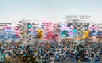
Explore the global festival scene
How can Google Earth and Google maps be used to investigate the site and situation of a given festival?
Key questions
How can I use Google Earth to find a place and place-mark its location?
How can Google Earth and Google maps be used to investigate the site and situation of a given festival?
How can I use Google Earth to find a place and place-mark its location?
Google Earth is a fantastic geographical data tool for locating and exploring different parts of the globe. By typing any destination into the fly to search box, Google Earth will take you to that location. Once there, you can drag the map, zoom in and out and explore the different layers. A place-mark can be attached to the map by clicking the add place-mark icon on the toolbar (a yellow pin). A screen appears, allowing the user to name their place-mark label and type in descriptive detail.
The starter activity requires students to find the location of their allocated festival and place a labelled place-mark on the map in the correct place. A suitable scale should be decided upon by zooming in/out until the map shows some detail of the surrounding area (for example, coastline/border, major settlements in the region).
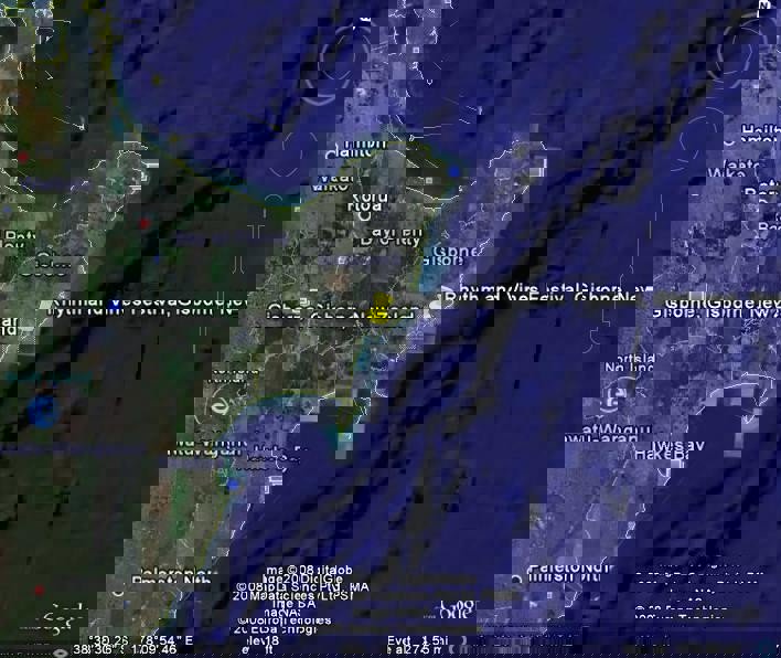
A sample map at a suitable scale showing the location of the Rhythm and Vines Festival in New Zealand with a labelled placemark has been provided. Further details on the locations on each of the festivals is detailed below.
Further information on Google Earth, including how to download the program, can be obtained from the Google Earth website.
How can Google Earth and Google maps be used to investigate the site and situation of a given festival?
During the main activity, students are required to use Google Earth, and Google Maps to find the locations of their given festivals, and to use information from these programs to answer questions about the site and situation of their festivals. Each group is provided with a task card to guide them through this activity.
There are five festivals in total. These can either be distributed equally throughout the class or given to students in five groups. The following background information is necessary for a teacher to be able to assist the students as they work through the tasks and to check their answers to the questions and their understanding of the site and situation of their festivals.
The Rhythm and Vines Festival takes place on the Waiohika Estate Vineyard near Gisborne, New Zealand (North Island). It is marketed as 'a kiwi summer festival experience like no other' and is a three day event held over the end of December/beginning of January to see in the New Year. It was established in 2003. The music is rock, dance, jazz and roots, hosting the best up and coming and established kiwi music. The Waiohika estate is 10.2km from Gisborne airport, which can be seen clearly on the satellite view of Gisborne in Google maps - about two miles to the east of the centre of Gisborne itself. The River Tursngsnui enters the sea at Gisborne in a wide sweeping bay. The settlement itself, the land to the west, and the vineyard to the north-west are all relatively flat. However, a ridge of mountains rises to over 200m fairly steeply to the east, providing a spectacular back-drop to the festival site. This makes an attractive setting for the festival, and zooming in on the map shows Gray's Bush reserve and Exotic/Native forests labelled. Away from Gisborne itself, the population becomes sparse and land-use is predominantly agricultural. Further information about this festival can be obtained from the festival website.
Southside Festival takes place about 1.8km to the north-west of Neuhausen Ob Eck (NOE) in south west Germany. The festival has been held every June since 1999, and it hosts mainstream/alternative music. It is held the same weekend as the Hurricane Festival in North Germany, which generally has the same line-up. Although relatively high (800m above sea level) the relief is fairly flat around NOE itself and the festival site, although it becomes more undulating a little further to the north where there is a river valley, making the setting attractive. It's not far from the Bodensee - a large lake on the River Rhine which separates Germany, Switzerland and Austria. Away from the settlement of NOE itself the population is sparse and the land-use is mainly agriculture or forestry. The nearest road to the festival site is the 311. Trains to Tuttlingen are met by a shuttle bus service during the festival, and the 11km journey takes about 13 minutes. Further information about this festival can be obtained from the festival website.
Hip Hop KEMP takes place about four kilometres to the north of the settlement of Hradec Kralove in the Czech Republic. As its name suggests, it is a hip hop festival and is held every August. It's one of the largest hip hop festivals in Europe, with around 20,000 people attending each year. The Hip Hop KEMP 05 photograph the students are instructed to find shows that the relief is very flat, and that there is a river on the site. There is also a series of lakes in the immediate area. The photograph was taken looking east from across the other side of the river which runs to the west of the festival site. The land-use is again, largely agricultural and while there are settlements in the locality, they are small and the overall population density is sparse. There is a railway line running close to the river to the west of the site. Further information about this festival can be obtained from the festival website.
The EXIT Festival takes place in Novi Sad, Serbia. It is a four day event that has been held every year in July since 2000. It aims to provide "relevant entertainment to Serbian youth while also bringing pertinent social topics to the fore" (quote from Wikipedia) The settlement is located on both sides of a meander bend in the River Danube. Unlike the other festivals which are all located outside of settlements, this one takes place within the settlement itself. However, when examined on the maps closely, students will find that it takes place around the old Turkish Petrovaradin Fort - this is an open area of the city with woodland on the banks of the River Danube. Therefore, it is away from the more densely populated areas of the settlement on the other side of the river. The settlement itself is located on flat land which rises to forested slopes further south, creating a pleasant setting for the festival. As the festival takes place within the settlement itself, communications are good, and the E75 road is the closest main road to the festival site on the map. Further information about this festival can be obtained from the festival website.
Benicassim Festival, or the Festival Internacional de Benicàssim (FIB) takes place on a concreted site to the south west of the coastal settlement of Benicassim in Spain (about 25km north along the coast from Castellon de la Palma on the east coast). It is one of the most important summer indie music events in Europe, and has been held annually in July since 1995. The setting for the festival is very attractive - the coast with mountains behind - rising to over 600m (this mountainous area is called ‘Desert De Las Palmes' on the map). However, the settlement itself and the festival site are located on flat land - this can be seen in the photographs the students are asked to look at and describe (they can also see the backdrop of mountains). The festival takes place away from the more densely populated settlement, as the land becomes more agricultural. The festival site is very well located in terms of road communications - the N340 road runs adjacent to the site, and the main AP-7 ‘Autopista Del Mediterrani' expressway is just to the north of the site (this links many of the main settlements on the Mediterranean Coast). Further information about this festival can be obtained from the festival website.
Starter
Where does my global festival take place?
For this activity you will need to work in a small group of four or five. Each group will pick one global festival to investigate. The different options are given on the starter cards.
Once you know which festival you will be working on, you need to find its location using Google Earth. There are instructions on how to do this on the activity card for your festival. You will also label it with a placemark. The Google Earth example shows you what your finished placemark might look like.
Main Activity
The site and situation of my global festival
You will continue studying the same festival for the next activity. The instruction cards give some instructions for you to follow.
There are two tasks in this activity:
-
Task one uses Google Earth
-
Task two uses Google Maps
There are also questions on the sheet for you to answer. You should add your answers to the text box attached to your Google Earth placemark.
Plenary
Presentation to the class
Each group will present their global festival to the class. When it is your turn, make sure you mention the following things about your global festival:
-
Which festival you studied
-
Its location
-
A summary of your findings about the festival's site and situation
-
Your Google Earth map and placemark
File nameFiles
File type
Size
Download