January 2023
One of the worst flood events to strike New Zealand occurred around Auckland on Friday 27 January 2023, with prolonged rainfall causing unprecedented flooding. A state of emergency was declared by the Auckland Mayor, Wayne Brown.
The event was described as New Zealand‘s ‘biggest downpour’ with the deluge setting a new record. A whole summer’s worth of rain fell in a single day making it the wettest day on record for the country.
Figure 1 The Auckland rainfall event 27 January © MetService, Meteorological Service of New Zealand Ltd
The causes
This level of rainfall is unprecedented in New Zealand. A record 261mm of rain fell over the course of just 18 hours. In some places as much as 150mm fell in the space of only 3 hours.
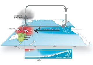
This heavy rainfall is attributed to the La Niña climate pattern, which brings warmer-than-normal sea-surface temperatures, lower air pressure, and increased rain. Estimates of nearby sea surface temperatures suggest that water off the west coast of New Zealand was 2 to 3°C higher than normal for January marine temperatures. Higher air temperatures also allowed more moisture to be held in the atmosphere. This all led to severe flooding.
Figure 2 below illustrates the La Niña phenomenon for Australia and New Zealand. Protracted La Niña conditions began in September 2020 and are a major influence on climate patterns in various parts of the world.
The impacts
-
Auckland airport closed from Friday to midday Saturday for domestic flights and until Sunday morning for international arrivals
-
Landslides and flash floods occurred in Auckland
-
Homes and cars were destroyed in Tauranga
-
~375 houses in Auckland were ‘yellow stickered’ only allowing temporary return
-
More than ~100 in Auckland were ‘red stickered’ meaning residents could not return at all
-
40,000 fans were notified, last minute, that a performance by Sir Elton John at the Mt Smart Stadium was cancelled
-
A state of emergency was declared by Kieran McAnulty, New Zealand’s minister for emergency management
-
Schools closed only reopening on 7 February
-
Extensive flooding around the train tracks in Te Puke caused a freight train to derail
-
On 27 January, the emergency services received an estimated 1500 calls for assistance
-
Prime Minister Chris Hipkins attributed the flooding to climate change
The aftermath
Insurers in Auckland, the biggest city in New Zealand, have described the flood as ‘the biggest climate event’ in the country’s history as the city begins the clean-up progress.
In mid-February, a state of emergency still persists. Some government agencies are being coordinated by Auckland Emergency Management because of further bad weather from Cyclone Gabrielle. A red warning was issued on 13 February for heavy rain and strong winds for the city, as well as Great Barrier Island and other islands in the Hauraki Gulf. On 14 February the storm hit New Zealand causing further flooding and a storm surge, with a high tide peak at 2am for east Auckland. A National State of Emergency was declared by Kieran McAnulty, New Zealand’s minister for emergency management. Two weeks on from the event 8 people are still missing and officials warn that the final cost of the storm could rise above $8bn.
The impacts of the storm are expected to be severe due to ground in and around the city already being saturated, causing surface flooding and landslides. The ground slips as water alters the pressure within the slope, reducing the soil strength in the process.
Further reading
-
National Geographic La Niña
-
Guardian News YouTube New Zealand floods: drone footage shows derailed train and landslides
-
Reuters The worst of the rain to hit New Zealand's Auckland may have passed
-
The Guardian Auckland floods: city begins clean-up after ‘biggest climate event’ in New Zealand’s history
-
FloodList New Zealand – 20,000 Insurance Claims Made After Auckland Floods
-
NME Elton John gig in Auckland cancelled just minutes before stage time after huge floods
-
CNN New Zealand’s biggest city braces for more heavy rains after deadly floods
-
The Conversation Slippery slopes: why the Auckland storm caused so many landslides – and what can be done about it
-
The Guardian Weather tracker: Auckland hit by wettest January on record
-
The Guardian After Cyclone Gabrielle, New Zealand wonders how – and if – to rebuild
-
NZ Herald In pictures: Dramatic images of Auckland’s big flood
-
Stuff Auckland weather recap
-
NZ Herald Auckland Anniversary weekend weather: Flooding, power cuts, traffic chaos
-
RNZ Wild weather: Crashes, power cuts as severe thunderstorm watch issued for northern NZ
-
RNZ Weather updates: State of emergency declared as severe flooding hits Auckland, Northland
-
Reuters New Zealand says cyclone damage could exceed $8 billion