Key words
-
Volcano
-
Volcanic Plume
-
Lava flow
-
Pyroclastic material
-
Convergent plate boundary
Summary
Fieldwork for this project took place in February-March 2012 and the research will continue in the future. Sampling of volcanic gas clouds was undertaken at three different volcanic cones in Chile using four different methods, in co-operation with OVDAS (the Southern Chile Volcano Observatory).
Overview of the Research
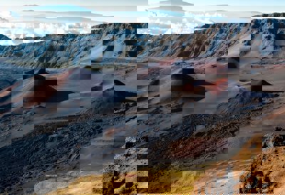
The aims of this research were to assess the chemistry of volcanic plumes from three active volcanoes; Villarrica - one of Chile’s most active stratovolcanoes, Puyehue-Cordon Caulle - a recently erupting explosive volcano and Lascar - a periodically exploding volcano in the Chilean altiplano. The research looked at data from volcanic plumes and tested new methodology against known results from previous research. The research aims to better understand the chemical composition, notably S02, of volcanic plumes at different stages of activity with the ultimate aim to find chemical signatures which may give insight into an upcoming eruption.
Aims of the Research
-
To test the effectiveness of different methodologies in measuring the chemical compositions of volcanic gas
-
To use this information to assess whether chemical data collected from active volcanoes can be used as a signature for predicting volcanic activity from future eruptions
Research techniques
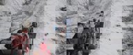
Prior to fieldwork the researchers met with the OVDAS to better understand the volcanic cones and potential hazards, as well as to discuss optimum data collection sites. There were four different methods used to assess the chemical composition of the volcanic cones:
-
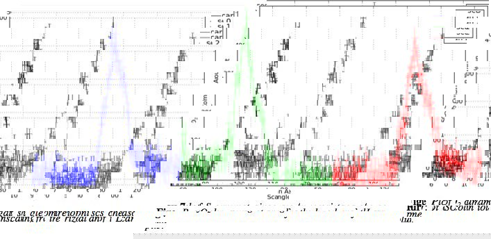
UV camera - a stationary UV camera was used to scan the area above the crater to collect photons from scattered sunlight. These were collected to quantify the S02 concentration in comparison with areas of plume free sky
-
UV Spectroscopy - a scanning device of scattered sunlight used to determine S02 in the atmosphere around the cone. This device - called an ‘AvoScan’ is mounted on a rotating tripod to scan across the area above the volcanic plume
-
Sun Photometry - a handheld device which measures aerosol thickness within a volcanic plume (and in non-plume areas) to help determine aerosol distribution. Such data will be useful for determining the impacts of volcanic aerosols on local climates. Used in close proximity to the crater to optimise data collection.
-
Filter Packs - A series of filters installed within an air pump. Air is drawn through the pump and filters collect different particles to determine chemical composition. This is set up in close proximity to the crater.
Key Topics and themes
This will be of particular interest to A-Level students studying Tectonic Activity, but is also a valuable resource for all students interested in understanding the activity of different volcanoes and how researchers collect data from the field.
The resource provides:
-
A case study of three contrasting active volcanoes in Chile - an area poorly covered by many core texts
-
An understanding of the features associated with volcanoes on convergent plate boundaries
-
An understanding of how data collection on volcanoes can be used to help mitigate hazards
-
A comparison of Chilean volcanoes to other globally known examples
-
An insight into the volcanic research beyond A Level
It may also be used as a means to show how volcanic eruptions impact upon the their local climate.
Documents to download
Links to the AS and A2 Syllabuses
Location Map of the Volcanoes
About the author
Martin Parham is a GCSE Principal Examiner and is currently undertaking a PhD focusing on the impact of natural hazards on small island communities. He has also while having recently completed his MRes in Volcanic Hazards. He currently teaches at Lingfield Notre Dame school in Surrey where is holds the position of Head of Geography. His main research interests include the impact of natural hazards on different socio-economic groups and how education can mitigate hazards. Additionally, he is currently writing articles for publication in Geography Review on the volcanism in the Canary Islands and an update on the impacts of super volcanic eruptions. Through his teaching role he has developed a series of volcanic field tours across Iceland, La Palma, Lanzarote and the Aeolian Islands and Yellowstone National Park to allow students to experience hazards firsthand.
The researchers
We are The Volcanofiles, a group of PhD students at the University of Cambridge exploring the world one volcano at a time. Tehnuka Ilanko studies volcanic gas emissions at Erebus lava lake, Antarctica. Yves Moussallam is studying experimental petrology and volcanic gas monitoring. Kelby Hicks specializes in the geology, natural hazards and remote sensing of active volcanic systems around the world. Kayla Lacovino studies the chambers where magma forms deep within the earth through experimental petrology. Nial Peters uses infrared cameras to study the dynamics of the lava lake at Erebus volcano, Antarctica.
