This module moves from the macro (an overview of Europe) to the micro (everyday life in the historic city of Bologna, Italy) whilst identifying core opportunities for learning at each geographical scale.
What's on the map? A bird's eye view on Europe
This lesson takes a bird's eye view on Europe. In this lesson, children begin to build up a picture of Europe, using a range of maps to start investigating the continent, its principal cities, coastlines, nations, rivers and mountains. It establishes basic locational knowledge of Europe, using geographical language and concepts to describe its location within the wider world. It develops an understanding that Europe is comprised of many different countries.
The lesson uses map-building as a tool, and supports learners’ understanding that there are different kinds of maps, which are used for a variety of functions, but that maps will often have common features (scale, key, purpose, orientation, title etc). The lesson also helps develop learners’ map-reading skills, including the use of longitude, latitude, and the four compass points. At the end of the lesson children will be introduced to a rolling assessment task, which they will add to following each lesson, forming a record of their learning throughout the module.
Is Europe a proper continent? Is the Mediterranean a proper sea?
This lesson takes a ‘geography conundrums approach’, moving in from the continent as a whole to the Mediterranean Sea. It builds on the map that learners have already started to build, and invites them to think critically about what we mean by terms such as ‘continent’ and ‘sea’, and to consider how different places and features fit together.
What's so special about the Mediterranean?
In this lesson pupils create ‘messages in a bottle’ from each country of the European Mediterranean. Each message will describe some of the main attributes of that country. We follow the flow of the bottle from the Straits of Gibraltar and, as it travels across Europe, following the main sea currents. The lesson demands that we ask: how does the sea affect life in the countries that border it? What is so special about The Mediterranean? What are some of its human and natural wonders? What connections do we have to it?
Zoom in on Italy - a country of Cities and Regions
This lesson ‘zooms’ in on Italy as a country of regions and cities. It considers the notion of scale within a country and encourages enquiry into the division of Italy into regions and how those regions function with their unique character and histories. This includes an investigation into seven famous ‘capoluogi’, the regional cities of Rome, Venice, Naples, Palermo, Milan, Aosta and Florence. How does this compare with the ways in which other countries are organised?
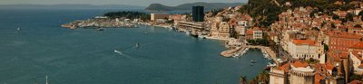
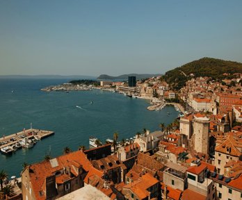
Zoom in on Bologna and the Bolognese – A City of Education and a City of Food
In this lesson pupils look in more detail at one specific city. Bologna is the capoluogo of the Emilia Romagna region, a city of education and a city of food. Pupils are invited to devise their own process for enquiring into an aspect of life in the city. This activity encourages reflection on the positives and negatives of life in Bologna, and things that they find interesting about it.
Everyday Life in Bologna
The final lesson of the module focuses on the everyday lives of four students from Bologna. The lesson explores how their calendars and daily activities are impacted on by the city they live in. There is also the opportunity to make comparisons between the individual students’ lives which encourages reflection on wider differences between life in Italy and the UK.
The lesson ends with learners zooming back out, from Bologna, to Italy, the Mediterranean and Europe as a whole, recapitulating what has been learnt. Finally, learners create a PowerPoint or Prezi presentation based on the assessment tasks they have been completing throughout the module, and this forms the basis for a final assessment.
About the authors
Ben Ballin is an educator, trainer and writer, specialising in primary geography, global learning and sustainable development. He is a member of the editorial board of Primary Geography magazine.
Jane Whittle taught for four years in Nottinghamshire before moving to Italy where she now teaches Humanities and coordinates the IB MYP Programme at the International School of Bologna. She is a Geographical Association Geography Champion and is a member of the GA Primary Phase Committee.
What's on the map? Bird's eye view on Europe
What's so special about the Mediterranean?
Is Europe a proper continent? Is the Mediterranean a proper sea?
Zoom in on Italy: A country of Cities and Regions
Zoom in on Bologna and the Bolognese – A City of Education and a City of Food