
Bodmin snow
A snowy day in Winter 2005: Heavy snow stops traffic on main route through Cornwall
More than 1,000 people were left stranded in their vehicles on one of the busiest roads in Cornwall because of heavy snowfall. On Friday 25 November 2005 hundreds of cars became stuck on the A30 over Bodmin Moor after the slippery conditions caused a crash involving several cars. Helicopters and all-terrain vehicles were brought in to rescue the stranded motorists, taking them to emergency accommodation in nearby leisure centres for the night.
Many children also got stuck in their schools for several hours, as the snow meant they could not leave and parents could not come to collect them. Almost 70 of Cornwall's 273 schools were closed.
Impacts
Health and wellbeing
Despite the terrible conditions and many crashes, the only injuries to people involved a fire engine, which came off the A30 on the way to answer an emergency call. One firefighter was taken to hospital by helicopter with serious, but not life-threatening, injuries.
Disruption to transport
A30 closed with gridlocked traffic. Railway services were affected. Fallen trees on one of the railway lines from London to Penzance caused trains to be delayed.
People stranded at home/on the road/at school
About 2,000 school pupils were stuck in schools and their teachers had to look after them. Some school children were forced to stay at homes of teachers and friends, and in hotels. A number of weather-sensitive outdoor events and some indoor events, such as pony show-jumping competitions, were cancelled on Saturday 26 November.
Financial effects on local economy
Likely to have ran into several hundreds of thousands, or even millions, of pounds. There was the cost of carrying out rescue operations and setting up of emergency shelters. The impact of people not attending work and goods not being delivered to businesses is likely to have added to the cost of the incident.
What happened to cause this weather?
Snow
Snow is a frozen type of precipitation. Precipitation also includes rain, hail, sleet, fog etc. Snow normally occurs when precipitation occurs and the air temperature at ground level is below 2 °C. Snow is most common in the UK in the winter months. The snow which affected the south-west of England on 25 November was an unusual occurrence in November, as it an autumn month.
Snow depths tend to only be measured once per day at 9 a.m. It is likely that at the height of the event snow depths were greater, but this may have melted overnight. There may also be other locations, where there are no weather stations, which had greater depths of snow.
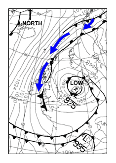
Weather chart
Snow can occur when air reaches us from a northerly or easterly direction, this helps to define the air mass.
Figure one shows the weather chart at midday on Friday 25 November. The blue arrows show air has moved down from the Arctic to reach south-west England. This air is flowing anticlockwise around the area of low, so the wind direction over the south-west of England is a northerly.
The air mass type is Arctic Maritime. This is cold and moist air which often has periods of snow. The little cold front over south-west England, shown by a line with triangles, indicates where the snow is long-lasting and heaviest. There is more about surface pressure charts in the weather section of the Met Office website.
Satellite imagery
Figure two is an animation visible satellite images from 1pm to 5pm on Friday 25 November.
The brightest white areas show where the thickest cloud is and where snowfall is most likely to be falling. The thickest cloud occurs over Bodmin Moor at around 2pm and 3pm.
The satellite is sensing how much sunlight is being reflected from the cloud. The darkening of the last image is about the time of sunset at 5pm. The dark areas of the picture over Exeter at 3pm and 4pm show where the cloud has cleared.
Radar imagery
Figure three is a animation of the radar imagery from 11am to 6pm on Friday 25 November. The legend, or key, shows the water equivalent in millimetres (mm) per hour. 1mm of water is about the same as a 10mm deep snowfall.
The radar imagery suggests the band of snow is moving westwards. It shows that it snowed for most of the day over Bodmin Moor before stopping around 6 p.m. It also suggests some high rates of snowfall at times, shown by the pink colours, e.g. 8.0-12.0 mm per hour.
Air temperatures
The temperature remained below 1 °C for the whole of this period on Bodmin Moor, and over much of the surrounding area. When the precipitation occurred, it did fall as snow and, because the roads were so cold, it was easy for it to settle on the A30 road surface.
File nameFiles
File type
Size
Download