Boscastle floods
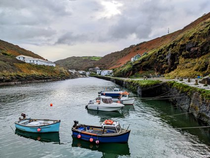
Floods devastate village: On 16 August 2004, a devastating flood swept through the small Cornish village of Boscastle.
Very heavy rain fell in storms close to the village, causing two rivers to burst their banks. About two billion litres of water then rushed down the valley straight into Boscastle.
Residents had little time to react. Cars were swept out to sea, buildings were badly damaged and people had to act quickly to survive. Fortunately, nobody died - thanks largely to a huge rescue operation involving helicopters — but there was millions of pounds worth of damage.
Physical Impacts
Flooding
On the day of the flood, about 75mm of rain fell in two hours — the same amount that normally falls in the whole of August. Huge amounts of water from this sudden downpour flowed into two rivers, the Valency and Jordan (which flows into the Valency just above Boscastle). Both overflowed, and this caused a sudden rush of water to speed down the Valency — which runs through the middle of Boscastle.
Destruction of houses, businesses and gardens
Floodwater gushed into houses, shops and pubs. Cars, walls and even bridges were washed away. The church was filled with six feet of mud and water. Trees were uprooted and swept into peoples' gardens. The weight of water eroded river banks, damaged gardens and pavements.
Human Impacts
There was a huge financial cost to the floods. This included:
-
the rescue operation - involving helicopters, lifeboats, and the fire service.
-
the loss of 50 cars
-
damage to homes, businesses and land
-
a loss of tourism, a major source of income for the area
The flooding also had several other key impacts on Boscastle and its inhabitants. These included:
-
environmental damage to local wildlife habitats
-
coastal pollution caused as debris and fuel from cars flowed out to sea.
-
long-term disruption to the village, as a major rebuild project had to be carried out.
-
long-term stress and anxiety to people traumatised by the incident.
Responses to the flooding
-
John Prescott, the Deputy Prime Minister, and Prince Charles visited members of the emergency services and the local GP surgery, which acted as the emergency centre, in the days following the disaster.
-
Prince Charles, who is the Duke of Cornwall, made a large donation to a fund to help rebuild parts of Boscastle.
-
The Environment Agency is responsible for warning people about floods and reducing the likelihood of future floods. The Environment Agency has carried a major project to increase flood defences in Boscastle, with the aim of preventing a similar flood happening again.
-
We are investing in new ways of predicting heavy rainfall events on a small scale to produce better warnings.
What happened to cause this event?
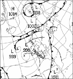
Weather map
Figure one shows the weather map for midday on 16 August.
The wind is blowing anticlockwise about the low pressure area, so the air is arriving into Boscastle from a south-westerly direction. It is a warm and moist tropical maritime air mass.
The line labelled (known as a trough line) caused very heavy rain and thunderstorms. A trough is an area of localised rain and thunderstorms. A line of convergence formed near the coast line, where air moving in almost opposite directions collides, this helped to increase the rate of ascent and produced very heavy rain.
There is more about surface pressure charts in the weather section of the Met Office website.
Radar imagery
Figure two shows an animation radar pictures from 12pm (midday) to 7pm on 16 August.
The rainfall rate key shows how the colours in the image relate to the rate the rainfall is falling. For example, the red areas indicate that rain is falling at between eight and 16 mm per hour.
A line of very heavy rain starts at about 1 p.m. on the moors close to Boscastle. It remains over the area for about six hours. Rainfall rates of at least 32 mm per hour are being measured.
There is more about rainfall radar in the weather section of the Met Office website.
Satellite imagery
Figure three shows an animation of satellite pictures from 12pm (midday) to 7pm on 16 August
The thickest cloud is shown by the brightest white areas on the picture. The pictures show cloud forming over Boscastle at about 1pm and staying there for much of the afternoon.
File nameFiles
File type
Size
Download