What story does this visualisation tell?
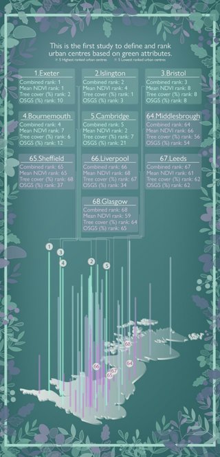
The image shows the 'greenness' of each town and city centre across Great Britain, with green bars showing the greenest centres and purple bars showing the least green centres. The infographic summarises the highest- and lowest-ranked centres and includes the breakdown of the datasets used to calculate the overall measure of greenness. The top five green centres are mostly in the south of England, compared to the bottom five, which are ex-industrial areas in the north of the country or in Scotland.
We identified a statistical link between a lower greenness score and higher levels of deprivation (using local authority district summaries from the 2019 Index of Multiple Deprivation). In addition, areas with larger populations had lower tree coverage and vegetation index scores.
Why was it created?
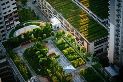
Green space is important for biodiversity and the movement of animals, as well as for human wellbeing and social equity. Trees can also reduce surface temperature, which is particularly important as the intensity of the urban heat island effect (localised heating caused by heat retention in densely urban areas) is greatest in the city centre. Whilst some of Great Britain’s city centres are filled with trees and parks, others have little vegetation to break up the bricks, tarmac and concrete. We wanted to understand the spatial pattern of, and factors influencing, the greenness of our town and city centres.
Around 70% of the world’s population will soon live in urban environments, and given the important benefits associated with greenery, it is a matter of social justice that all people should have equity of provision. This ties in with the United Nations' Sustainable Development Goal (SDG) of ensuring that people have universal access to safe, inclusive and accessible green and public spaces (SDG11: Sustainable Cities and Communities).
Research exploring green areas has often focused on the places around people’s homes. Prior to our research, no studies had focused specifically on town/city centres, where people of diverse backgrounds may spend much time on activities such as work, recreation, and shopping. We hypothesised that larger centres might face increased development pressures and therefore have less green in their urban cores. Additionally, we wanted to explore the level of greenness of cities developing at different time periods and if levels of deprivation in the city influenced its greenness.
Who was the intended audience?
Our main audiences were the general public and local authorities – specifically those working in urban planning and large-scale development. We wanted to make local authorities aware of gaps in the current provision of greenness to ensure all opportunities to enhance greenspace in our town/city centres are considered.
What data did you use to create it and why?
The greenness of a place can be measured in numerous ways. We wanted to generate an approach combining multiple elements, so we used a range of freely available open data, supplemented with data only available at Universities through Digimap (a mapping service also available to many schools).
We assessed three metrics of 'greenness':
-
tree cover using an algorithm to randomly sample recent aerial imagery.
-
the presence of greenspaces using open-source data from Ordnance Survey (Great Britain’s national mapping agency, abbreviated to OSGB in the infographics).
-
the normalised difference vegetation index (NDVI), which uses satellite observations of light absorption and reflection to measure vegetation cover.
We combined the three measures using Principal Component Analysis (PCA), a process to reduce large and complex datasets. This was required as tree cover could be included in many of the green variable measurements, and we did not want to give too much weight to a single factor. We also undertook a more simplistic Z-Score approach (which combines data based on averages and standard deviations) to validate and ensure that we were confident in our findings.
Town/city centres were defined using Consumer Data Research Centre spatial datasets, which use complex statistics to demarcate retail boundaries. This is a really important aspect of the work as changing the boundary of the centre impacts the level of greenness within the area.
Why did you choose to present the data in this way over other approaches?
As we were interested in the spatial pattern of greenness, a map was the intuitive way to present our findings. From experience, people are far more likely to want to look at data if it is presented in a map or chart rather than a large table. We used the top and bottom five town/city centres as a mechanism to simplify the message and draw out key points. The data is available from the Supporting information section of our published article.
Some people misinterpreted our work – thinking that we measured greenness within the entire town or city, but our work focused on the core or 'central business district'. Many of the towns/cities that lacked greenery within their core had good greenspace outside the centre. However, our particular interest was in urban centres where people spend time on work and recreation activities and where the urban heat island effect is the most intense.
What impact has the visualisation had in research, policy, or other contexts?
The map and data allow people to identify their town or city centre's greenness and compare it to others they know. As the data are available to anyone to use, people can create their own maps to show this important set of information.
The dissemination of our work has really surprised us. It was featured in all the leading domestic newspapers (featuring in over 150 news outlets). We anticipate that, in due time, this will lead to impact and help inform efforts by local authorities and urban planners to boost the greenness of town/city centres in a fair and equitable manner.
We hope that our work highlights the importance of considering the greenness of our town/city centres within the current levelling-up agenda. Town/city centres are changing, especially as digital shopping means many retail outlets are closing. This is a problem in many ways but also an opportunity. The decline of in-person shopping allows us to re-envision and redevelop urban centres to enhance their greenspaces.
How can the visualisation be taken a step further?
Future research could incorporate alternative greenness metrics or apply a similar analysis to town/city centres outside Great Britain. In addition, it would be interesting to see how the rankings change over time.
If someone wanted to recreate a similar style of visualisation, how would they go about it?
The visualisation was generated using a Geographic Information System (GIS) and was edited using image-editing software. There are many other similar opportunities. The key questions to consider are how you might measure what you are interested in, what is the best spatial scale to use and what data are currently available?
Whilst we downloaded data through the Digimap service (for UK colleges and universities) for ease – data can also be obtained from other open data sources. For example, OS Open Greenspace is available from Ordnance Survey; NDVI data from Sentinel-2 can be generated from the Copernicus Open Access Hub and the tree analysis can be undertaken using iTree Canopy.
In Great Britain, there is a wealth of socioeconomic data that are freely available. Good starting places are the Office for National Statistics Geoportal and Nomis – the official census and labour market statistics, where you can download the latest 2021 Census data for England and Wales.
About the creators
Dr Paul Brindley is a senior Lecture in Landscape Architecture at the University of Sheffield. His research focuses on understanding the interplay between landscapes and people through digital data and GIS mapping (Geographic Information Science). Landscape Architecture embraces all aspects of the science, planning, design, creation and management of the landscape in both urban and rural environments. It covers all scales, from the smallest garden to the greatest wilderness.
You can find out more about Paul on his University of Sheffield profile or by following him on Twitter @DrPaulBrindley.
Dr Jake Robinson is a microbial ecologist with an interest in spatial ecology and the connections between biodiversity and human health. You can learn more about Jake on his website or on Twitter @_jake_robinson.