Applying geographical science to settle a 160 year-old border dispute
Geographical research has provided crucial evidence that underpinned rulings by the International Court of Justice (ICJ). This led to the peaceful resolution of a 160-year border dispute along the largest river in Central America between Costa Rica and Nicaragua.
Issue
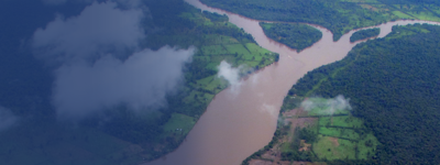
In October 2010, Nicaragua’s army occupied part of Costa Rica and oversaw work intended to change the course of the Río San Juan, which marks the border. The occupation relates to a border dispute dating back to the Treaty of Limits signed in 1858. The area occupied is part of the Humedal Caribe Noreste (Northeast Caribbean Wetland), which is designated as a wetland of international importance under the Ramsar Convention (1996) and supports species of plants and animals that are vulnerable to, or under threat of, extinction.
Approach
The purpose of the research was to collect and analyse the data necessary to establish whether accusations made by both countries in both cases were technically correct and scientifically valid. A scientific research programme was undertaken to inform the Court on cartographic, fluvial and environmental issues underpinning the legality and impacts of Nicaragua’s and Costa Rica’s actions in both cases. This included reconstructing the geological and geomorphological histories of the contested region using maps, satellite images, photographs (aerial and ground) and texts, in collaboration with Costa Rican technical specialists.
Impact
The research provided crucial evidence to permanently settle a 160-year border dispute. It was documented that the alignment of the Río San Juan and, hence, the border between Costa Rica and Nicaragua remains as depicted in the 1858 Treaty of Limits, the Cleveland Award of 1888 and the first and second Alexander Awards of 1897. The Court ruled that Nicaragua did violate Costa Rica’s territorial sovereignty.
The research also demonstrated that the dredging, excavation and tree felling activities in the disputed area resulted in significant environmental harm. The severity of the harm, which involved clearing of rainforest and excavating wetlands, led the Court, for the first time in its history, to award damages to a nation state in restitution for the environmental harm done by another state.
More information
Institution: University of Nottingham
Researchers: Professor Colin Thorne
Share this resource
This is an open access article under the terms of the Creative Commons Attribution License (CC BY NC 4.0), which permits use, adaptation, distribution and reproduction in any medium or format, provided the original work is cited and it is for non-commercial purposes. Please contact us for other uses.
How to cite
Royal Geographical Society (with IBG) (2023) Applying geographical science to settle a 160 year-old border dispute Available at https://rgs.org/160year-oldborderdispute Last accessed on: <date>