Building infrastructure resilience through innovative monitoring and forecasting of landslide hazards in the North of the UK
Research at Newcastle University has led to the development of novel, low-cost live streaming sensors and data processing systems which have been adopted by Transport Scotland and their contractors.
Issue
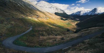
Landslides that affect roads are life-threatening and lead to negative social and economic impacts because of travel disruptions and road closures. The ability to forecast whether a landslide is likely to occur, or is occurring, and where it will impact, is critical for public and private organisations who manage and maintain road and rail infrastructure. There is a balance to be struck between ensuring the safety of road users and the economic and social consequences of road closures, which can be highly disruptive for local residents and businesses.
Approach
Geographers at Newcastle University studied how interrogating real-time data from innovative technological developments can inform more effective decision-making. This is driven by novel, low-cost methods and sensors that can forecast periods of likely landslide activity and detect the precursors to landslides days before final failure.
Impact
In the wake of landslide events in December 2015 and January 2016, the Newcastle researchers were commissioned to lead a Transport Scotland (TS)-directed Scottish Roads Research Board project to install novel, low-cost seismometers and develop feature tracking time-lapse cameras.
In 2018, 10 days prior to landslides triggered by Storms Ali and Callum, the Newcastle team alerted TS to movement on the slope. Based on the efficacy of Newcastle’s approach, TS have funded and maintained four deformation dSLR tracking cameras and have adopted resilient site-wide Wi-Fi.
This research has driven the development of new integrated and hierarchical networks of sensors, most of which are not conventionally used in monitoring and managing landslide hazard for acute events. The A83 is now the most densely monitored slope in Scotland, at a far lower cost than more conventional systems.
In April 2018, the Newcastle team were asked by the British Mountaineering Council (BMC) to install their streaming monitoring systems at Castle Rock of Triermain in the Lake District, a popular climbing crag on land owned by United Utilities. The research on failure prediction was used to word warning signs more appropriately and alert stakeholders to increasing risk.
The Newcastle team were later invited to assess Cumberland County Council (CCC) roads threatened by landslides to deploy solutions; and by the British Mountaineering Council to deploy solutions at further hazardous climbing sites.
More information
Institution: Newcastle University
Researchers: Dr Stuart Dunning, Dr Rupert Brainbridge, Professor Andrew Large, Professor Andrew Russell, Dr Anne-Sophie Meriaux
Share this resource
This is an open access article under the terms of the Creative Commons Attribution License (CC BY NC 4.0), which permits use, adaptation, distribution and reproduction in any medium or format, provided the original work is cited and it is for non-commercial purposes. Please contact us for other uses.
How to cite
Royal Geographical Society (with IBG) (2023) Building infrastructure resilience through innovative monitoring and forecasting of landslide hazards in the North of the UK. Available at https://rgs.org/monitoringlandslidehazard Last accessed on: <date>