Using Earth Observation to tackle modern slavery
Geographers at the University of Nottingham used remotely-sensed imagery, machine-learning and citizen science to map sites where there is a high risk of modern slavery.
Issue
Today, 40,300,000 people are enslaved. The UN and all countries have set the target of ending slavery by 2030. But no country has a system for actively monitoring slavery and this lack of data leads to poor interventions and policies.
Approach
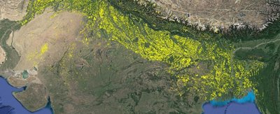
The Slavery from Space programme at the University of Nottingham aims to address this problem. The programme uses Earth Observation (EO) to identify and track the scars left on the Earth by the industries with high levels of slavery. This includes fish-processing in Bangladesh, brick-making in India, Pakistan, Bangladesh and Nepal, deforestation in Mozambique, cobalt-mining in the Democratic Republic of Congo, agriculture in Greece, and multiple sectors in Uganda.
Impacts
Since July 2019, the India-based NGO Volunteers for Social Justice (VSJ) has used these data and maps to identify brick kilns in northern India and to liberate bonded labourers, as well as improving working conditions and securing unpaid wages and access to welfare. UNDP integrated these data into a mobile app that inspectors use to select specific kilns for ground-level inspection.
In Greece, field visits showed that living and working conditions for migrant agricultural workers around Nea Manolada had not improved following an ECHR ruling. The researchers' data and risk assessment tool were embedded at the national level in Greece’s actions to address forced labour.
More information
Institution: University of Nottingham
Researchers: Professor Doreen Boyd, Professor Giles Foody
Share this resource
This is an open access article under the terms of the Creative Commons Attribution License (CC BY NC 4.0), which permits use, adaptation, distribution and reproduction in any medium or format, provided the original work is cited and it is for non-commercial purposes. Please contact us for other uses.
How to cite
Royal Geographical Society (with IBG) (2023) Using Earth Observation to tackle modern slavery. Available at https://rgs.org/tacklemodernslavery Last accessed on: <date>