Use geography: careers in risk management and insurance
What does a career in the sector look like?
With the UK insurance market worth over £200 billion, and more than 320,000 people working within it, there are huge opportunities for graduates looking to enter the industry, particularly those with specialist knowledge and skills.
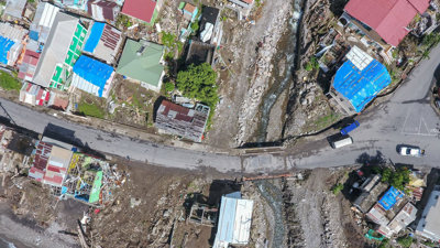
Geography is highly relevant for careers in insurance and risk management. Geographers’ abilities to understand and analyse human and environmental changes and hazards are important to risk analysis and management, as is the ability to model risks and to understand impacts on communities and regions.
Roles in risk management
Roles in managing risk can vary from risk management work in an actuarial context, to project work for a local council or environmental management company, to roles in the finance sector.
The technical work of quantifying and mitigating risks can involve using GIS to map hazards, or, in an insurance context, developing models to project risks in a particular place, business or sector.
A career in this sector can also involve project management, working with clients and undertaking consultations (in the context of, for example, flood risk management). Opportunities are varied.
Learn more about the paths geographers take in this sector in our career profiles. Search for 'risk' and 'insurance'.
Discover the impact you could have while working in insurance and risk with our case studies. Search for 'risk', 'insurance', and 'disaster'.
More resources on this topic
-
CareersInRisk.com – Risk Careers Advice
-
TargetJobs – Financial Services and Insurance
-
Prospects – Job Profiles: Political Risk Analyst
-
Prospects – Environment Agency careers
-
Atkins - Meet our geographers: What does a flood risk consultant do?
John Kreft, Senior Analyst Natural Hazards at WSP
"A large part of my role is to develop WSP in New Zealand’s capability to help government agencies, local authorities and other clients manage geohazards effectively and efficiently, using GIS and data science.
"Another part of this role requires me to look for new ways to inform on natural hazard risk and exploring new data sources to facilitate this.
"As my role is so varied, there is no such thing as a typical week, which is great as it keeps it so interesting."

Katie Boon, Technical Advisor for Flood and Coastal Risk Asset Management at the Environment Agency
"My responsibilities are very varied and include: identifying and bidding for future works; project management; maintaining close relationships with all internal teams, consulting prior to works and taking action to enhance knowledge on all environmental aspects that require attention; responding to Flood Risk Activity Permits (FRAP); using ArcGIS software to visually present projects; and proactively engaging with significant stakeholders."

Webinar - Use geography: careers in risk and insurance
Watch our webinar on starting a career in the sector with geography, with panellists Dr Tina Thomson CGeog, William Forde and Prof Richard Teeuw.
Advice on getting a job in the sector
Andrew Fielding, Flood Risk and GIS Analyst for JBA Consulting
"Research the industry and apply for voluntary work. This could be with councils, consultancies, water companies, engineering companies; there are vast amounts of opportunities.
"The knowledge you’ll gain from this is invaluable and there are so many different pathways to explore."

Jessica Prest, Sustainable Drainage Systems and Flood Risk Officer at Cambridge County Council
"Most careers in flood risk involve regular use of GIS. While most roles provide training in this software, prior experience is seen as a valuable skill by employers within this sector. Therefore, I would advise choosing the more GIS-based modules within your degree.
"In my third year I studied a module on environmental hazards which included coursework which involved producing a report to assess flooding in Salisbury, England and develop a flood protection strategy for the area, with the use of Geographical Information Systems (GIS) to aid this work.
"This provided skills particularly relevant for my role, which involves assessing Flood Risk Assessments and using GIS on a daily basis."

Tina Thomson, Head of Catastrophe Analytics EMEA West-South, Willis Towers Watson
"The key is to explore different fields early on, try out internships during university to get an idea of which industry appeals to you and speak to professionals in the various fields, and don’t be afraid to ask for a mentor to help guide you.
"The best opportunity will be through joining a learned society, networking with the student body and by attending meetings and conferences."

Stay informed about our upcoming career webinars and other events.